Region Ucayali
| Region Ucayali | |||
|---|---|---|---|
 | |||
| Symbole | |||
| |||
| Basisdaten | |||
| Staat | Peru | ||
| Hauptstadt | Pucallpa | ||
| Fläche | 102.411 km² | ||
| Einwohner | 496.459 (2017) | ||
| Dichte | 4,8 Einwohner pro km² | ||
| ISO 3166-2 | PE-UCA | ||
| Webauftritt | www.regionucayali.gob.pe (spanisch) | ||
| Politik | |||
| Gobernador regional | Francisco Pezo Torres (2019–2022) | ||
 | |||
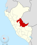
Die Region Ucayali [] (span. Región Ucayali, Quechua Ukayali suyu) ist eine ostperuanische Region. Auf einer Fläche von 102.411 km² leben 496.459 Menschen (2017).[1] Die Hauptstadt ist Pucallpa. Der Name der Region leitet sich vom Fluss Ucayali ab.
Geographie
Die Region Ucayali grenzt im Osten an Brasilien, im Norden an Loreto, im Westen an Huánuco, Pasco, Junín, im Süden an Cusco und Madre de Dios.
Sie ist hauptsächlich von tropischem Regenwald bedeckt. Das Klima ist meist feucht und heiß. Die durchschnittliche Jahrestemperatur beträgt 25 °C.
Provinzen
Die Region ist in vier Provinzen und zwölf Distrikte unterteilt.
| Provinz | Hauptstadt |
|---|---|
| Atalaya | Atalaya |
| Coronel Portillo | Pucallpa |
| Padre Abad | Aguaytía |
| Purús | Puerto Esperanza |
Weblinks
Einzelnachweise
Auf dieser Seite verwendete Medien
Mapa Provincias Ucayali
Autor/Urheber: Mediante concurso publico, Lizenz: CC BY-SA 4.0
Representa el símbolo regional de Ucayali
Autor/Urheber:
- Peru_-_(Template).svg: Huhsunqu
- derivative work: Huhsunqu (talk)
Locator map of Ucayali Department in Peru.


