Río Paraguay
| Río Paraguay Rio Paraguai | ||
 Río Paraguay in der Nähe von Asunción | ||
| Daten | ||
| Lage | ||
| Flusssystem | Río de la Plata | |
| Abfluss über | Río Paraná → Río de la Plata | |
| Quellgebiet | Mato Grosso, nahe Nortelândia 14° 36′ 42″ S, 56° 29′ 10″ W | |
| Quellhöhe | ca. 420 m | |
| Mündung | nördlich Corrientes in den Río ParanáKoordinaten: 27° 17′ 24″ S, 58° 36′ 26″ W 27° 17′ 24″ S, 58° 36′ 26″ W | |
| Mündungshöhe | ca. 47 m | |
| Höhenunterschied | ca. 373 m | |
| Sohlgefälle | ca. 0,14 ‰ | |
| Länge | 2695 km | |
| Einzugsgebiet | ca. 1.168.540 km² | |
| Abfluss AEo: 1.168.540 km² | MQ Mq | 2700 m³/s 2,3 l/(s km²) |
| Linke Nebenflüsse | Rio Taquari | |
| Rechte Nebenflüsse | Río Pilcomayo, Río Bermejo | |
| Großstädte | ||
| Mittelstädte | ||
 Rio Paraguay im Einzugsgebiet des Río de la Plata | ||
Der 2549 km lange in Südamerika fließende Río Paraguay, port. Rio Paraguai, ist der bedeutendste Nebenfluss des Río Paraná. In seinem Oberlauf heißt er auf Portugiesisch Rio Paraguai, in seinem Unterlauf auf Spanisch Río Paraguay. Die Bezeichnung auf Guaraní lautet Ysyry Paraguái. Der Name bedeutet „Wasser, das zum Wasser geht“, abgeleitet von der Sprache der Ureinwohner, Guaraní: pará („Ozean“), gua („zu/von“) und y („Wasser“).
Flusslauf
Der Río Paraguay entspringt in Brasilien im gebirgigen Hochland von Mato Grosso ungefähr 115 km nördlich von Cuiabá. Von dort aus fließt der Río Paraguay in südlicher Richtung. Er verlässt das Hochland und durchquert die Niederung des Pantanal. Dort fließt er zumeist parallel zur bolivianischen Grenze. Im Süden des Pantanals bildet er die Grenze zwischen Brasilien und Paraguay. Anschließend durchquert er Paraguay in Nord-Süd-Richtung und fließt dabei an der paraguayischen Hauptstadt Asunción vorbei. Dort vereinigt er sich auch mit seinem größten Nebenfluss, dem Río Pilcomayo. Unmittelbar danach bildet er die Grenze zwischen Paraguay und Argentinien. Etwas nördlich von Corrientes mündet er in den Paraná.
Bedeutung
Der Río Paraguay ist der längste und größte Fluss Paraguays. Er ist auf 2000 km Länge schiffbar. Nach dem Paraná ist er der zweitwichtigste Handelsweg der Staaten, die er durchfließt. Sein größter Hafen ist Asunción. Er ist Bestandteil der internationalen Wasserstraße Paraná-Paraguay.
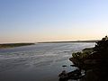 Der Río Paraguay bei Asunción
 (c) waldeir_nogueira, CC BY-SA 3.0Eisenbahnbrücke über den Paraguay
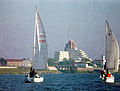 Segelregatta vor Asunción
 Der Paraguay im Satellitenbild
Einzugsgebiet
Der Paraguay umfasst ein Einzugsgebiet von 1.168.540 km²; es reicht in die Staaten Brasilien, Bolivien, Paraguay und Argentinien.
 Nebenflüsse: Rio Cuiabá im Mato Grosso,
 … der Río Tebicuary
bei Sonnenuntergang, … die Einmündung
des Río Bugres, … der Río Pilcomayo
mit Brücke … und der Río Bermejo als Grenzfluss zwischen Argentinien und Bolivien
Siehe auch
Weblinks
Auf dieser Seite verwendete Medien


| Flagge von Bolivia* | |
|---|---|
| country | Template:I18n/Republic of Bolivia |
| genutzt von | Bolivia |
| von | 1851 |
| bis | Present |
| entworfen von | Government of Bolivia |
| Format | 15:22 |
| Form | Rechteck |
| Farben | Rot, Gelb, Grün
Flagge hat 3 horizontale Streifen |
| sonstige Eigenschaften | A horizontal tricolor of red, yellow and green. |


Autor/Urheber: Mateus Hidalgo, Lizenz: CC BY-SA 2.5 br
Confluence of the rivers Bugres (at left) and Paraguai River (at right), in the city of Barra do Bugres.
_y_Argentina_(dcha).jpg)
Autor/Urheber: Sean Mulry, Lizenz: CC BY 2.0
Bolivia Argentina Border


Autor/Urheber: Kmusser, Lizenz: CC BY-SA 3.0
Map showing the Río de la Plata drainage basin including major tributaries and cities.
.jpg)
Autor/Urheber: NASA Goddard Space Flight Center from Greenbelt, MD, USA, Lizenz: CC BY 2.0
Paraná River, Argentina and Paraguay February 1984.
The effects of the rainy season in south-central South America are vividly documented in this near-vertical photograph of the confluence of the Paraná and Paraguay Rivers northeast of the Argentine town of Corrientes. The Paraná River flows westward; after merging with the Paraguay River, it begins to flow almost due south. Both rivers are sediment laden and appear to be out of their normal watercourses, thereby producing flooding conditions. The Paraguay River is characterized by the widely varying, meandering main channel; many oxbow lakes; and a tan sediment load. The Paraná River has a smaller floodplain, a deeper channel, and a reddish-brown sediment load. As the two rivers merge and begin to flow southwestward, their individual sediment patterns do not mix readily, a common occurrence in which rivers with different densities of suspended particles tend to retain their individual color characteristics for many miles downstream. The Paraná River, which flows approximately 2000 miles (3200 kilometers), is the second largest drainage system in South America; the Amazon River is the largest. An old river channel south of the Paraná River parallels the present river channel. This much older stream channel seems to flow toward the city of Corrientes (estimated population of 200 000), the commercial center for this rich agricultural region of northeast Argentina and southwest Paraguay.
NASA Goddard Space Flight Center is home to the nation's largest organization of combined scientists, engineers and technologists that build spacecraft, instruments and new technology to study the Earth, the sun, our solar system, and the universe.
Follow us on Twitter
Join us on Facebook
(c) waldeir_nogueira, CC BY-SA 3.0
Ponte rio paraguai - Porto Esperança II

Autor/Urheber: Nicofsa, Lizenz: CC BY-SA 4.0
Regata on the Paraguay River, with downtown Formosa (Argentina) and the Hotel Internacional de Turismo (1970) in the background.