Quinebaug River
| Quinebaug River | ||
Karte des Einzugsgebietes | ||
| Daten | ||
| Gewässerkennzahl | US: 210057 | |
| Lage | Windham County, Connecticut (USA) | |
| Flusssystem | Thames River (Connecticut) | |
| Abfluss über | Shetucket River → Thames River → Long Island Sound | |
| Quelle | Holland Pond 42° 4′ 55″ N, 72° 9′ 49″ W | |
| Quellhöhe | 385 m | |
| Mündung | Mündung in den Shetucket RiverKoordinaten: 41° 33′ 22″ N, 72° 2′ 46″ W 41° 33′ 22″ N, 72° 2′ 46″ W | |
| Mündungshöhe | 8 m | |
| Höhenunterschied | 377 m | |
| Sohlgefälle | 16 ‰ | |
| Länge | 24 km | |
| Linke Nebenflüsse | French River (Massachusetts), Moosup River, Five Mile River, Wales Brook, Mill Brook, Cady Brook | |
| Durchflossene Stauseen | East Brimfield Dam, Westville Dam, West Thompson Dam | |
| Mittelstädte | Norwich, New London, | |
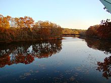
Der Quinebaug River in Thompson | ||
Der Quinebaug River ist ein Fluss im südlichen Zentral-Massachusetts und im östlichen Connecticut mit einem Einzugsgebiet, dass sich bis nach Rhode Island erstreckt. Der Name "Quinebaug" entstand aus einem Begriff der einheimischen Indianer der etwa Qunnubbâgge, Quinibauge, oder ähnlich gesprochen wurde. Er bedeutet "Langer Teich" (von qunni- = lang, -paug = Teich).[1] Der Fluss ist einer der namengebenden Flüsse des Quinebaug and Shetucket Rivers Valley National Heritage Corridor.
Verlauf
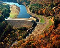
Der Fluss ist etwa 69 mi (111 km) lang.[2] Er entspringt aus dem East Brimfield Lake und weiteren Teichen nordwestlich von Sturbridge, Massachusetts. Er verläuft generell in südöstlicher und südlicher Richtung durch Connecticut (Putnam, Danielson, Plainfield, Canterbury und Jewett City). Der Fluss ergießt sich in den Aspinook Pond, der sich von Canterbury bis Jewett City erstreckt und mündet bald darauf von Links und Osten bei den Quinebaug Falls in den Shetucket River. Der Zusammenfluss liegt nordöstlich von Norwich. Der Shetucket führt seine Wasser über den Thames River dem Long Island Sound zu. Der Quinbaug River ist am Oberlauf an verschiedenen Stellen angestaut: East Brimfield Dam, Westville Dam und West Thompson Dam dienen der Hochwasserkontrolle und es gibt eine ganze Anzahl von kleinen Dämmen, die der Gewinnung der Wasserkraft dienen.
Einzugsgebiet
Das Einzugsgebiet umfasst 2.200 km² (850 sqmi). Der größte Teil des Gebiets ist stark bewaldet und es gibt mindestens 29 namhafte Zuflüsse sowie sechs Hauptzuflüsse (French, Moosup River, Five Mile River, Wales Brook, Mill Brook, Cady Brook). Im Einzugsgebiet liegen auch 54 Seen und Teiche, von denen 31 eine Fläche von 10 acre (4 ha) oder mehr aufweisen, insgesamt etwa 3.000 acres (12 km²) Wasserfläche; der größte See ist East Brimfield Reservoir in Brimfield und Sturbridge mit 420 acre (1,7 km²). In den Gewässern sind viele Fischarten heimisch, die von Anglern gerne gefischt werden: Regenbogenforelle, Schwarzbarsch, Forellenbarsch, Hecht und Panfish. Der Höhenunterschied beträgt ca. 378 m. Der Ursprung liegt bei 1264 ft (385 m) über dem Meer am Mount Pisgah in Wales, Massachusetts und fällt auf 25 ft (8 m) in Norwich.
Brücken
| State | County | Town | Carries | Built |
|---|---|---|---|---|
| CT | New London | Lisbon and Griswold | Providence and Worcester Railroad | |
| 1956 | ||||
| Silvandale Road crossing | ||||
| Windham | Canterbury | Providence and Worcester Railroad | ||
| Butts Bridge Road | ||||
| Canterbury und Plainfield | ||||
| Brooklyn und Plainfield | ||||
| Brooklyn und Killingly | ||||
| Pomfret und Killingly | ||||
| Cotton Bridge Road | ||||
| Putnam | Landfill access bridge | |||
| Airline Rail Trail | ||||
| Bridge Street | ||||
| Thompson | West Thompson Road | 1964 | ||
| Blain Road | ||||
| Red Bridge Road | 1964 | |||
| Brickyard Road | 1964 | |||
| Fabyan Road | 1999 | |||
| MA | Worcester | Dudley | ||
| Southbridge Branch RR | ||||
| West Dudley Road | ||||
| Southbridge | East Main Street | |||
| AO Factory Road | ||||
| AO Factory Pedestrian Bridge | ||||
| AO Factory Pedestrian Bridge | ||||
| AO Factory Pedestrian Bridge | ||||
| Pipeline crossing | ||||
| Business Park Road | ||||
| 1956 | ||||
| Central Street | ||||
| River Street | ||||
| Mill Street | 1956 | |||
| Sturbridge und Southbridge | Westville Dam service road | 2003 | ||
| Breakneck Road/Wallace Road | 1956 | |||
| Sturbridge | Old Mashapaug Road | 1956 | ||
| Grand Trunk Rail Trail | 2002 | |||
| Farquhar Road | 1939 | |||
| Haynes Street | 1961 | |||
| 1971 | ||||
| Old Sturbridge Village Road | 1972 | |||
| OSV Pedestrian Bridge | ||||
| OSV Covered Bridge | ||||
| Stallion Hill Road | 1956 | |||
| Holland Road | 1956 | |||
| Hampden County | Brimfield | Holland-East Brimfield Road | 1958 | |
| Holland | Morse Road | 1939 | ||
| Pond Bridge Road | 1934 |
Freizeitmöglichkeiten
Drei Flussabschnitte wurden als National Recreation Trail ausgeschrieben und sind nun beliebte Routen für Bootstouren: Holland Pond bis zum East Brimfield Reservoir; Paper Mill Dam in Dudley bis zum West Thompson Lake; Simonzi Park in Putnam bis zum Aspinook Pond in Canterbury. Auch der East Coast Greenway verläuft streckenweise entlang des Flusses.
Es gibt Bootsrampen an den folgenden Stellen:
- Pond Bridge Road, Holland
- US Route 20 boat ramp, Brimfield
- Old Mashapaug Road, Sturbridge
- West Dudley Road, Dudley
- Fabyan Road, Thompson
- West Thompson Lake boat ramp, Thompson
- Simonzi Park on Kennedy Drive, Putnam
- Route 101, Pomfret
- Riverside Park off Day Street, Brooklyn
- Town Park off Route 12, Killingly
- Quinebaug Trout Hatchery, Plainfield
- Robert Manship Park off Route 14, Canterbury
- Butts Bridge Road, Canterbury
Galerie
Einzelnachweise
- ↑ William Bright: Native American placenames of the United States. University of Oklahoma Press, 2004, ISBN 978-0-8061-3598-4, S. 405 (Abgerufen am 14. April 2011).
- ↑ U.S. Geological Survey. National Hydrography Dataset high-resolution flowline data. The National Map.
Weblinks
- Rhode Island Watershed Partnership (Memento vom 23. September 2006 im Internet Archive)
- Columbia Gazetteer of North America (Memento vom 18. März 2007 im Internet Archive)
- Environmental Protection Agency
- Massachusetts Department of Environmental Protection
Auf dieser Seite verwendete Medien
Autor/Urheber: User:Magicpiano, Lizenz: CC BY-SA 4.0
The Quinebaug River in Thompson, Connecticut.
A shield for a Connecticut state highway. Uses the Roadgeek 2005 fonts. (United States law does not permit the copyrighting of typeface designs, and the fonts are meant to be copies of a U.S. Government-produced work anyway.)
Westville Lake and Dam on the Quinebaug River near Southbridge, Worcester County, Massachusetts, USA. The U.S. Army Corps of Engineers constructed the dam for flood control on the river.
Autor/Urheber: User:Magicpiano, Lizenz: CC BY-SA 4.0
View of Putnam, Connecticut and the Quinebaug River.
East Brimfield Lake and Dam on the Quinebaug River in Hampden County, Massachusetts, USA. The dam was constructed by the U.S. Army Corps of Engineers for flood control on the Quinebaug River.
600 mm × 600 mm (24 in × 24 in) U.S. Highway shield, made to the specifications of the 2004 edition of Standard Highway Signs. (Note that there is a missing "J" label on the left side of the diagram.) Uses the Roadgeek 2005 fonts. (United States law does not permit the copyrighting of typeface designs, and the fonts are meant to be copies of a U.S. Government-produced work anyway.)
A shield for a Connecticut state highway. Uses the Roadgeek 2005 fonts. (United States law does not permit the copyrighting of typeface designs, and the fonts are meant to be copies of a U.S. Government-produced work anyway.)
Autor/Urheber: Cathy Cline, Lizenz: CC BY-SA 3.0
National Historic Place, Butts Bridge Rd. over Quinebaug River
A shield for a Connecticut state highway. Uses the Roadgeek 2005 fonts. (United States law does not permit the copyrighting of typeface designs, and the fonts are meant to be copies of a U.S. Government-produced work anyway.)
Map of the Quinebaug River and environs, Massachusetts and Connecticut, USA.
A shield for a Connecticut state highway. Uses the Roadgeek 2005 fonts. (United States law does not permit the copyrighting of typeface designs, and the fonts are meant to be copies of a U.S. Government-produced work anyway.)
A shield for a Connecticut state highway. Uses the Roadgeek 2005 fonts. (United States law does not permit the copyrighting of typeface designs, and the fonts are meant to be copies of a U.S. Government-produced work anyway.)
750 mm by 600 mm (30 in by 24 in) Massachusetts Route shield, made to the specifications of the 1996 edition of Construction and Traffic Standard Details (sign M1-5). Uses the Roadgeek 2005 fonts. (United States law does not permit the copyrighting of typeface designs, and the fonts are meant to be copies of a U.S. Government-produced work anyway.) The outside border has a width of 1 (1 mm) and a color of black so it shows up; in reality, signs have no outside border. The specs actually do not show the curve on the outside border, instead making it a perfect rectangle, but all signs I have seen round the corners.
A shield for a Connecticut state highway. Uses the Roadgeek 2005 fonts. (United States law does not permit the copyrighting of typeface designs, and the fonts are meant to be copies of a U.S. Government-produced work anyway.)
A shield for a Connecticut state highway. Uses the Roadgeek 2005 fonts. (United States law does not permit the copyrighting of typeface designs, and the fonts are meant to be copies of a U.S. Government-produced work anyway.)
750 mm by 600 mm (30 in by 24 in) Massachusetts Route shield, made to the specifications of the 1996 edition of Construction and Traffic Standard Details (sign M1-5). Uses the Roadgeek 2005 fonts. (United States law does not permit the copyrighting of typeface designs, and the fonts are meant to be copies of a U.S. Government-produced work anyway.) The outside border has a width of 1 (1 mm) and a color of black so it shows up; in reality, signs have no outside border. The specs actually do not show the curve on the outside border, instead making it a perfect rectangle, but all signs I have seen round the corners.
600 mm × 600 mm (24 in × 24 in) U.S. Highway shield, made to the specifications of the 2004 edition of Standard Highway Signs. (Note that there is a missing "J" label on the left side of the diagram.) Uses the Roadgeek 2005 fonts. (United States law does not permit the copyrighting of typeface designs, and the fonts are meant to be copies of a U.S. Government-produced work anyway.)


