Pulau Bum Bum
| Pulau Bum Bum | ||
|---|---|---|
 | ||
| Gewässer | Celebessee | |
| Geographische Lage | 4° 28′ N, 118° 41′ O | |
| Länge | 16 km | |
| Breite | 12,8 km | |
| Fläche | 45 km² | |
| Höchste Erhebung | 20 m | |
| Einwohner | 20.000 444 Einw./km² | |
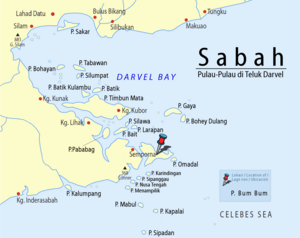
Pulau Bum Bum (manchmal auch Pulau Bum Bun) ist eine zum östlichsten malaysischen Staat Sabah gehörende Insel an der Südostseite der zur Celebessee offenen Darvel Bay. Die Insel liegt im Distrikt Semporna der Tawau Division. Sie liegt etwa einen Kilometer östlich von Semporna und ist die zweitgrößte Insel der Darvel Bay. Sie ist in Teilen dicht bewaldet. Die Insel ist unregelmäßig geformt, erinnert aber insgesamt an ein auf dem Kopf stehendes, flaches Dreieck. Ihre maximale Ausdehnung in Nord-Süd-Richtung beträgt ca. 12,8 km, die in Ost-West-Richtung etwa 19,7 km.[Anm. 1] Sie erreicht vereinzelt Höhen bis zu 20 m; die Wipfelhöhe der Bewaldung wird mit 46 bis 52 m angegeben. Die Insel ist durch einen schiffbaren Kanal – den Terusan Tando Bulong – vom Festland getrennt.[1]
Demografie
Auf der Insel leben 20.000 bis 30.000 Menschen in 34 Siedlungen.[2][3]
Siedlungen
Die Dörfer auf Pulau Bum Bum sind entlang der Küstenlinie verteilt:[4]
- Kg. Manimpa
- Kg. Labuan Haji
- Kg. Gelam Gelam
- Kg. Look Button
- Kg. Seloka Empet
- Kg. Tanggal
- Kg. Samal Samal
- Kg. Terusan Manis
- Kg. Look Malalom
- Kg. Egang Egang
- Kg. Bum Bum
- Kg. Look Ibah
- Kg. Sisipan
- Kg. Nusalalong
- Kg. Kabimbangan
- Kg. Balimbang
- Kg. Terusan Tengah
- Kg. Tudun
- Kg. Pantau Pantau
- Kg. Terusan Labayan
- Kg. Terusan Look
- Kg. Terusan Baru
- Kg. Hampalan
- Kg. Hampalan Kajang
- Kg. Muslim
- Kg. Tongkalloh
- Kg. Kubang
- Kg. Gollom Gollom
- Kg. Muntai Muntai
- Kg. Labusai
- Kg. Tabunan
- Kg. Tabak Tabak
- Kg. Gusong Melanta
- Kg. Sulabayan
Infrastruktur
Die bewohnte Insel ist mit einem Straßennetz durchzogen.[4] Die Anbindung ans Festland erfolgt mit Fähren. Im Februar 2012 genehmigte das Finanzministerium ein Projekt im Wert von 100 Millionen Euro, mit dem eine 1,4 Kilometer lange Brücke die Insel ans Festland anbinden soll.[5]
Anmerkungen
- ↑ Die Werte wurden annähernd durch Auswertung der Satellitenaufnahme von google-Maps ermittelt.
Einzelnachweise
- ↑ Sailing Directions (Enroute) - Borneo, Jawa, Sulawesi and NUsa Tenggara. (Memento des vom 4. März 2016 im Internet Archive) Info: Der Archivlink wurde automatisch eingesetzt und noch nicht geprüft. Bitte prüfe Original- und Archivlink gemäß Anleitung und entferne dann diesen Hinweis. (PDF; 5,8 MB) United States Navy Publication 163, Sektor 10, 2002, S. 286; abgerufen am 24. August 2012
- ↑ Bridge linking mainland and Pulau Bum-Bum is a necessity, says Nasir. The Star, 3. Dezember 2011; abgerufen am 26. August 2012
- ↑ Proposed bridge construction linking Pulau Bum-Bum and mainland to spur development in the island The Star, 17. Oktober 2008; abgerufen am 26. August 2012
- ↑ a b Topographische Karte 1:90.000: Negeri Sabah Bahagian Tawau Daerah Semporna; Hrsg. Jabatan Ukur & Permetaan Malaysia, 1. Ausgabe, 2010
- ↑ RM430mil Semporna bridge approved. Daily Express, 29. Februar 2012; abgerufen am 26. August 2012.
Auf dieser Seite verwendete Medien
Autor/Urheber: Cccefalon; Pushpin: McSush, Lizenz: CC BY-SA 3.0
Sabah: Scheme of Islands in the Darvel Bay with Pushpin Marker for Pulau Bum Bum
Autor/Urheber: Uwe Dedering, Lizenz: CC BY-SA 3.0
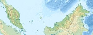
Location map of Malaysia.
Equirectangular projection. Strechted by 100.0%. Geographic limits of the map:
* N: 8.0° N
* S: 0.0° N
* W: 99.0° E
* E: 120.0° E
Made with Natural Earth. Free vector and raster map data @ naturalearthdata.com.
Flag of the Malaysian state Sabah. Based on a GIF from a government website, colors from a photo. Drawn by Mysid. The flag was adopted September 16, 1988.
- The mountain on the left is Mount Kinabalu.
Per the Constitution of the State of Sabah:
"The State Flag is in a rectangular shape and is in the proportion of 1:2. The canton which extends at the head half way to the fly and 2/3 at the hoist to the foot is in Icicle Blue (C1T9) as the background to a graphic silhouette of Mount Kinabalu which is in Royal Blue (B10) positioned at ¼ of the height of the canton from end to end. The fly of the flag is divided equally into three bands of colours the foot division of which extends right to the hoist. The top band is in Zircon Blue (C5T5) the second band is in white and the third band is in Chili Red (S6R4)."


