Przemyśler Land


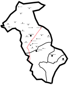
Das Przemyśler Land (polnisch Ziemia przemyska) war eine Verwaltungseinheit der Polnisch-litauischen Adelsrepublik in der Woiwodschaft Ruthenien von 1434 bis 1772. Hauptort war Przemyśl.
Es umfasste die Powiat (Kreise)
- Powiat Przemyśl (Powiat przemyski), Hauptort Przemyśl
- Powiat Sambor (Powiat samborski), Hauptort Sambor
- Powiat Drohobycz (Powiat drohobycki), Hauptort Drohobycz
- Powiat Stryj (Powiat stryjski), Hauptort Stryj
1676 hatte das Przemyśler Land 32 Städtchen und 980 Dörfer.
Literatur
- K. Przyboś: Granice Ziemi Przemyskiej w czasach nowożytnych XVI–XVIII w. (Die Grenzen des Przemyśler Landes vom 16. bis 18. Jahrhundert), Przemyśl 1993.
- K. Arłamowski, u. a. (Hrsg.): Lustracja województwa ruskiego 1661–1665 (Wojewodschaft Ruthenien 1661–1665), Bd. 1: Ziemia przemyska i sanocka (Przemyśler und Sanoker Land). Wrocław, Warszawa, Kraków 1970.
Auf dieser Seite verwendete Medien
Autor/Urheber: Alex Tora, Lizenz: CC BY 3.0
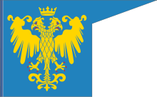
Flags of Ruthenian lands in the battle of Tannenberg, 1410.
Autor/Urheber: D T G, Lizenz: CC BY-SA 4.0
Land of Przemyśl In Poland before 1772, (thick black line) and 4 counties (thin black lines), and the state border after WW2 (red dotted line); borders are not precise, based on [1] and [2]

