Provinz Coronel Portillo
| Provinz Coronel Portillo | |||
|---|---|---|---|
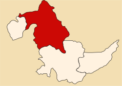
 Lage der Provinz in der Region Ucayali | |||
| Symbole | |||
| |||
| Basisdaten | |||
| Staat | Peru | ||
| Region | Ucayali | ||
| Sitz | Pucallpa | ||
| Fläche | 36.816 km² | ||
| Einwohner | 384.168 (2017) | ||
| Dichte | 10 Einwohner pro km² | ||
| Gründung | 1943 | ||
| ISO 3166-2 | PE-UCA | ||
| Webauftritt | municportillo.gob.pe (spanisch) | ||
| Politik | |||
| Alcalde Provincial | Segundo Leónidas Pérez Collazos (2019–2022) | ||
 | |||
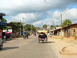
Die Provinz Coronel Portillo liegt in der Region Ucayali im Osten von Peru. Die Provinz hat eine Fläche von 36.816 km². Beim Zensus 2017 lebten 384.168 Menschen in der Provinz.[1] 10 Jahre zuvor lag die Einwohnerzahl bei 333.890.[1] Die Provinz wurde nach Pedro Portillo (1856–1916), peruanischer Offizier und Politiker, benannt. Verwaltungssitz ist die am Westufer des Río Ucayali gelegene Stadt Pucallpa.
Geographische Lage
Die Provinz Coronel Portillo erstreckt sich über das Amazonastiefland. Sie besitzt eine Längsausdehnung in NNW-SSO-Richtung von etwa 335 km. Die Provinz reicht im Westen bis zum Sira-Gebirge. Der Río Ucayali durchfließt den Westen der Provinz in nördlicher Richtung. Im Osten bildet die Wasserscheide zum weiter östlich gelegenen Einzugsgebiet des Rio Juruá die Provinz- und Staatsgrenze.
Die Provinz Coronel Portillo grenzt im Osten an Brasilien, im Süden an die Provinz Atalaya, im Westen an die Regionen Cusco und Huánuco sowie an die Provinz Padre Abad und im Norden an die Region Loreto.
Verwaltungsgliederung
Die Provinz Coronel Portillo gliedert sich in die folgenden sieben Distrikte. Der Distrikt Callería ist Sitz der Provinzverwaltung.
| Distrikt | Verwaltungssitz |
|---|---|
| Callería | Pucallpa |
| Campoverde | Campoverde |
| Iparía | Iparía |
| Manantay | San Fernando |
| Masisea | Masisea |
| Nueva Requena | Nueva Requena |
| Yarinacocha | Puerto Callao |
Einzelnachweise
- ↑ a b Coronel Portillo, Province in Ucayali Region. www.citypopulation.de, abgerufen am 30. November 2019.
Weblinks
Auf dieser Seite verwendete Medien
Autor/Urheber: Municipalidad Provincial de Coronel Portillo, Lizenz: CC BY 3.0
Flag of the province of Coronel Portillo in the Ucayali department, country of Peru.
Autor/Urheber: DSan, Lizenz: CC BY-SA 4.0
El Puente Maya de Brito, en la calle del mismo nombre, dividiendo la quebrada de Yumantay. Esto en el distrito de Manantay, ciudad de Pucallpa.
Autor/Urheber: AgainErick, Lizenz: CC BY-SA 3.0
Location of the province Coronel Portillo in the Ucayali region in Peru (Map)


