Prineville
| Prineville, Oregon | |
|---|---|
 | |
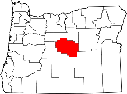
| Lage im County und im Bundesstaat | |
| Basisdaten | |
| Gründung: | 1877 Gründung 1880 inkorporiert |
| Staat: | Vereinigte Staaten |
| Bundesstaat: | Oregon |
| County: | Crook County |
| Koordinaten: | 44° 18′ N, 120° 51′ W |
| Zeitzone: | Pacific (UTC−8/−7) |
| Einwohner: | 10.736 (Stand: 2020) |
| Haushalte: | 4.456 (Stand: 2020) |
| Fläche: | 17,2 km² (ca. 7 mi²) |
| Bevölkerungsdichte: | 624 Einwohner je km² |
| Höhe: | 874,2 m |
| Postleitzahl: | 97754 |
| Vorwahl: | +1 541 |
| FIPS: | 41-59850 |
| GNIS-ID: | 1154317 |
| Website: | www.cityofprineville.com |
| Bürgermeister: | Jason Beebe[1] |
 Lamonta Compound – Prineville Supervisor’s Warehouse | |
Prineville ist eine Stadt und County Seat des Crook County im US-Bundesstaat Oregon. Ihr Name verweist auf den ersten dort ansässigen Händler, Barney Prine. Das U.S. Census Bureau hat bei der Volkszählung 2020 eine Einwohnerzahl von 10.736[2] ermittelt.
Geschichte
Prineville wurde 1877 gegründet, als Monroe Hodges die ursprüngliche Flurkarte für die Stadt anlegte. Das Postamt wurde im April 1871 zunächst auf den Namen Prine geführt, im Jahr darauf zu Prineville geändert. Im Oktober 1880 wurde die Stadt inkorporiert.[3] Die erste High school wurde 1902 eröffnet.
Als die Eisenbahn-Tycoons James J. Hill und Edward H. Harriman Prineville 1911 in ihrer Streckenführung ausschlossen, drohte sie zur Geisterstadt zu verkommen. Bei einer Abstimmung 1917 beschlossen Bürger Prineville mit 355 zu 1 Stimmen, ihre eigene Eisenbahnstrecke zu bauen und sammelten das Geld für den Anschluss an die 31 km entfernte Hauptstrecke.
Dank der Holzernte aus dem nahe gelegenen Ochoco National Forest entwickelte sich die City of Prineville Railroad jahrzehntelang prächtig. Die Gewinne aus der Eisenbahn waren so groß, dass die Stadt zwischen 1964 und 1968 keine Eigentumssteuern erhob. Mit dem Niedergang der Holzindustrie Oregons erwirtschaftete die Eisenbahn zwischen 2002 und 2004 einen Verlust von fast $1 Million.[4]
Der National Park Service führt für Prineville insgesamt fünf Gebäude im National Register of Historic Places an (Stand 5. Januar 2019), darunter das Lamonta Compound – Prineville Supervisor’s Warehouse.[5]
Geographie
Prineville liegt am Crooked River (Oregon) an der Mündung des Ochoco Creek, 23 km nordwestlich des Prineville Reservoirs.
Demographie
29,3 % der Bevölkerung waren bei der Volkszählung 2000 jünger als 18 Jahre; 9,6 % zwischen 18 und 24; 27,0 % zwischen 25 und 44; 18,6 % zwischen 45 und 64, sowie 15,5 % jenseits der 65 Jahre. Der Median lag bei 33 Jahren.
Der Median der Haushaltseinkommen lag bei $30.435, das Einkommen pro Kopf betrug $14.163.
Wirtschaft
Die Wirtschaft ist geprägt von holzverarbeitenden Betrieben, namentlich Sägewerken.
Die Reifenhändler-Kette Les Schwab Tire Centers hat seit ihrer Gründung 1952 Verbindung zu Prineville. Im Dezember 2006 kündigte die Firma an, ihre Zentrale ins nahegelegene Bend zu verlegen.
2010 wählte Facebook Prineville als Standort für ein neues Rechenzentrum, das auf einer Fläche von 2 Millionen Quadratmetern errichtet wurde.[6]
Persönlichkeiten
- Bill Pearl (1930–2022), Bodybuilder
Weblinks
- Eintrag Prineville im Oregon Blue Book
- Prineville Chamber of Commerce
- City of Prineville Railroad
- Prineville Territory Magazine
Einzelnachweise
- ↑ www.cityofprineville.com. (abgerufen am 13. April 2022).
- ↑ Explore Census Data Prineville city, Oregon. Abgerufen am 11. Januar 2023.
- ↑ W. H. Leeds: Special Laws. In: The State of Oregon General and Special Laws and Joint Resolutions and Memorials Enacted and Adopted by the Twentieth Regular Session of the Legislative Assembly. State Printer, Salem, Oregon 1899, S. 896 (google.com).
- ↑ City of Prineville Railroad
- ↑ Suchmaske Datenbank im National Register Information System. National Park Service, abgerufen am 5. Januar 2019.
- ↑ Mike Rogoway: Facebook picks Prineville for its first data center, OregonLive.com, 21. Januar 2010
Auf dieser Seite verwendete Medien
Autor/Urheber: Ian Poellet, Lizenz: CC BY-SA 3.0
The historic Lamonta Compound – Prineville Supervisor's Warehouse complex (built 1933), located on Lamonta Road in Prineville, Oregon, United States, is listed on the US National Register of Historic Places. The compound remains a support facility for the Ochoco National Forest. Stitched panorama from 3 original shots.
Autor/Urheber: Arkyan, Lizenz: CC BY-SA 3.0
This map shows the incorporated and unincorporated areas in Crook County, Oregon, highlighting Prineville in red. It was created with a custom script with US Census Bureau data and modified with Inkscape.
Autor/Urheber: Cacophony, Lizenz: CC BY-SA 3.0
A panoramic photo of Prineville, Oregon made from 3 segments. The photos were taken from the lookout point in Ochoco State Park.
This is a locator map showing Crook County in Oregon. For more information, see Commons:United States county locator maps.


