Prince George’s County
 | |
| Hoheitszeichen | |
|---|---|
| Verwaltung | |
| US-Bundesstaat: | Maryland |
| Verwaltungssitz: | Upper Marlboro |
| Adresse des Verwaltungssitzes: | County Administration Building 14741 Governor Oden Bowie Drive Upper Marlboro, MD 20772-3050 |
| Gründung: | 1696 |
| Gebildet aus: | Charles County, Calvert County |
| Vorwahl: | 001 301 |
| Demographie | |
| Einwohner: | 967.201 (Stand: 2020) |
| Bevölkerungsdichte: | 769,45 Einwohner/km2 |
| Geographie | |
| Fläche gesamt: | 1291 km² |
| Wasserfläche: | 34 km² |
| Karte | |
 | |
| Website: www.princegeorgescountymd.gov | |
Das Prince George’s County[1] ist ein County im US-Bundesstaat Maryland. Der Verwaltungssitz (County Seat) ist Upper Marlboro. Bei der Volkszählung im Jahr 2020 hatte das County 967.201 Einwohner und eine Bevölkerungsdichte von 769 Einwohnern pro Quadratkilometer.[2]
Das Prince George’s County ist Bestandteil der Metropolregion um die US-Hauptstadt Washington, D.C.
Geographie
Das County liegt am Ostufer des Potomac River im östlichen und südlichen Vorortbereich der US-Bundeshauptstadt Washington. Der Potomac bildet die Grenze zu Virginia. Das Prince George’s County hat eine Fläche von 1291 Quadratkilometern; davon sind 34 Quadratkilometer (2,61 Prozent) Wasserflächen. Es grenzt an folgende Countys und selbstständigen Städte:
| Montgomery County | Howard County | |
| Washington, D.C. |  | Anne Arundel County |
| Fairfax County (Virginia), Alexandria (Virginia) | Charles County | Calvert County |
Geschichte

Das County wurde 1696 aus Teilen des Charles und des Calvert County gegründet. Benannt wurde es nach Georg, Prinz von Dänemark (1653–1708), dem Ehemann von Königin Anne von Großbritannien.
1748 wurde auf einem ausgegliederten Teil des Prince George’s County das Frederick County gegründet. 1791 wurde für das neu zu gründende District of Columbia ein weiterer Teil aus dem County ausgegliedert.
Sechs Stätten im Prince George’s County haben aufgrund ihrer geschichtlichen Bedeutung den Status einer National Historic Landmark.[3] 100 Bauwerke und Stätten des Countys sind insgesamt im National Register of Historic Places eingetragen (Stand 14. November 2017).[4]
Demografische Daten
| Bevölkerungswachstum | |||
|---|---|---|---|
| Census | Einwohner | ± rel. | |
| 1790 | 21.344 | — | |
| 1800 | 21.175 | −0,8 % | |
| 1810 | 20.589 | −2,8 % | |
| 1820 | 20.216 | −1,8 % | |
| 1830 | 20.474 | 1,3 % | |
| 1840 | 19.539 | −4,6 % | |
| 1850 | 21.549 | 10,3 % | |
| 1860 | 23.327 | 8,3 % | |
| 1870 | 21.138 | −9,4 % | |
| 1880 | 26.451 | 25,1 % | |
| 1890 | 26.080 | −1,4 % | |
| 1900 | 29.898 | 14,6 % | |
| 1910 | 36.147 | 20,9 % | |
| 1920 | 43.347 | 19,9 % | |
| 1930 | 60.095 | 38,6 % | |
| 1940 | 89.490 | 48,9 % | |
| 1950 | 194.182 | 117 % | |
| 1960 | 357.395 | 84,1 % | |
| 1970 | 660.567 | 84,8 % | |
| 1980 | 665.071 | 0,7 % | |
| 1990 | 729.268 | 9,7 % | |
| 2000 | 801.515 | 9,9 % | |
| 2010 | 863.420 | 7,7 % | |
| 2020 | 967.201 | 12 % | |
vor 1900[5] 1900–1990[6] 2000 + 2010[7] | |||
Nach der Volkszählung im Jahr 2010 lebten im Prince George’s County 863.420 Menschen in 297.937 Haushalten. Die Bevölkerungsdichte betrug 686,9 Einwohner pro Quadratkilometer.
Ethnisch betrachtet setzte sich die Bevölkerung zusammen aus 19,2 Prozent Weißen, 64,5 Prozent Afroamerikanern, 0,5 Prozent amerikanischen Ureinwohnern, 4,1 Prozent Asiaten sowie aus anderen ethnischen Gruppen; 3,2 Prozent stammten von zwei oder mehr Ethnien ab. Unabhängig von der ethnischen Zugehörigkeit waren 14,9 Prozent der Bevölkerung spanischer oder lateinamerikanischer Abstammung.
In den 297.937 Haushalten lebten statistisch je 2,74 Personen.
24,8 Prozent der Bevölkerung waren unter 18 Jahre alt, 65,7 Prozent waren zwischen 18 und 64 und 9,5 Prozent waren 65 Jahre oder älter. 51,8 Prozent der Bevölkerung war weiblich.
Das jährliche Durchschnittseinkommen eines Haushalts lag bei 69.545 USD. Das Prokopfeinkommen betrug 30.917 USD. 7,8 Prozent der Einwohner lebten unterhalb der Armutsgrenze.[8]
Städte und Gemeinden
|
|
|
|
|
|
|
Census-designated places (CDP)
- Accokeek
- Adelphi
- Andrews Air Force Base
- Beltsville
- Brandywine
- Calverton1
- Camp Springs
- Carmody Hills-Pepper Mill Village
- Chillum
- Clinton
- Coral Hills
- East Riverdale
- Forestville
- Fort Washington
- Friendly
- Glenn Dale
- Goddard
- Greater Landover
- Greater Upper Marlboro
- Hillandale1
- Hillcrest Heights
- Kettering
- Konterra
- Lake Arbor
- Landover
- Langley Park
- Lanham-Seabrook
- Largo
- Marlow Heights
- Marlton
- Mitchellville
- Oxon Hill-Glassmanor
- Rosaryville
- South Laurel
- Springdale
- Suitland-Silver Hill
- Temple Hills
- Walker Mill
- West Laurel
- Woodlawn
- Woodmore
1 – teilweise im Montgomery County
Einzelnachweise
- ↑ Prince George’s County. In: Geographic Names Information System. United States Geological Survey, United States Department of the Interior, abgerufen am 5. September 2024 (englisch).
- ↑ Maryland (Bundesstaat, USA) - Einwohnerzahlen, Grafiken, Karte und Lage. Abgerufen am 1. März 2022.
- ↑ Listing of National Historic Landmarks by State: Maryland. National Park Service, abgerufen am 14. November 2017.
- ↑ Suchmaske Datenbank im National Register Information System. National Park Service, abgerufen am 14. November 2017.
- ↑ University of Virginia Library - Historical Census Browser Abgerufen am 7. September 2011
- ↑ United States Census.gov Abgerufen am 7. September 2011
- ↑ Auszug aus census.gov (2000+2010) ( des vom 29. Juli 2011 im Internet Archive) Info: Der Archivlink wurde automatisch eingesetzt und noch nicht geprüft. Bitte prüfe Original- und Archivlink gemäß Anleitung und entferne dann diesen Hinweis. Abgerufen am 4. April 2012
- ↑ U.S. Census Buero, State & County QuickFacts - Prince George’s County ( des vom 29. Juli 2011 im Internet Archive) Info: Der Archivlink wurde automatisch eingesetzt und noch nicht geprüft. Bitte prüfe Original- und Archivlink gemäß Anleitung und entferne dann diesen Hinweis. Abgerufen am 8. September 2011
Weblinks
- U.S. Census Buero, State & County QuickFacts - Prince George’s County
- Maryland State Archives - Prince George’s County
- Yahoo Bildersuche - Prince George’s County
- www.city-data.com - Prince George’s County
Koordinaten: 38° 50′ N, 76° 51′ W
Auf dieser Seite verwendete Medien
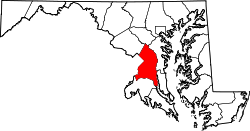
This is a locator map showing Prince George's County in Maryland.
David Benbennick made this map. For more information, see Commons:United States county locator maps.The flag of Prince George's County, Maryland, as officially defined in the county code. What differentiates it from many currently-used flags is that it uses the 1958 to 1971 county seal in the top left-hand corner instead of the current post-1971 seal. Although it is not as widely used, according to the county code, as of 2018, this is still technically the official flag of the county: "Sec. 1-106. County flag; contents. The official County flag shall be a three (3) feet by five (5) feet flag of white, divided in equal quadrants by four (4) inch stripes of red and containing in its upper left quadrant the official seal of the County as adopted by the Board of Commissioners on November 25, 1958. (Ord. and Res. 1967, Sec. 1-6)". However, in practice, most of the flags manufactured and currently used by the county disregard the county code's description of the flag and instead feature the post-1971 seal in the top left-hand corner. More information about the flag and seal can be found here, here, here, and here.
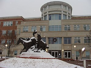
Image of the main entrance to the Prince George's County, MD Courthouse during a snow shower.
Autor/Urheber: Die Autorenschaft wurde nicht in einer maschinell lesbaren Form angegeben. Es wird WarXboT als Autor angenommen (basierend auf den Rechteinhaber-Angaben)., Lizenz: CC BY-SA 2.5
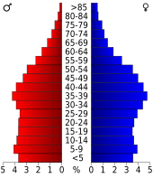
Age pyramid for Prince George's County, Maryland, United States of America, based on census 2000 data


