Preseli-Berge
Die Preseli-Berge (englisch Preseli Hills oder Preseli Mountains; walisisch Mynydd Preseli / Y Preselau) sind eine Hügelkette im Norden von Pembrokeshire in Wales, die einen Teil des Pembrokeshire-Coast-Nationalparks bilden. Den höchsten Punkt bildet mit 536 Metern Foel Cwmcerwyn.
Der neolithische Steinkreis Meini Gwyr (auch Buarth Arthur; dt. Arthurs Einhegung genannt) liegt nahe der Straße A478 bei Glandy Cross. Foel Drygarn ist ein Hillfort auf einem der Gipfel.
In den Preseli-Bergen wurden prähistorische Funde gemacht. Gefleckter Dolerit aus den Preseli-Bergen (Carn Meini Quarry) wurde beim Bau von Stonehenge (Bluestones) verwendet.
- Preseli-Berge
 (c) ceridwen, CC BY-SA 2.0
Carn Edward mit Sicht auf den Cerrig Lladron

Menhir am Cerrig Lladron
 Contains Ordnance Survey data © Crown copyright and database right, CC BY-SA 3.0
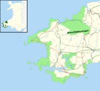
Karte der Preseli Hills
 (c) Dylan Moore, CC BY-SA 2.0
Carn Meini
Koordinaten: 51° 57′ N, 4° 46′ W
Auf dieser Seite verwendete Medien

Contains Ordnance Survey data © Crown copyright and database right, CC BY-SA 3.0
Map of the Preseli Hills in the Pembrokeshire Coast National Park, UK with the following information shown:
- National Park boundary
- Administrative borders
- Coastline, lakes and rivers
- Roads and railways
- Urban areas
Equirectangular map projection on WGS 84 datum, with N/S stretched 160%
Geographic limits:
- West: 5.60W
- East: 4.55W
- North: 52.15N
- South: 51.55N

Autor/Urheber: Helge Klaus Rieder, Lizenz: CC0
Cerrig Lladron Standing Stone - Preseli Hills, Pembrokeshire (Wales)

(c) Dylan Moore, CC BY-SA 2.0
Carn Menyn from Eglwyswrw There's a layby on the A487 that seems to have been put there just so people can get these evening views. The serrated edge of Carn Menyn is on the horizon, with Carn Alw (SN13873371) below it.
