Portsoy
| Portsoy schottisch-gälisch Port Saoidh | |||
|---|---|---|---|
 | |||
| Koordinaten | 57° 41′ N, 2° 42′ W | ||
| |||
| Traditionelle Grafschaft | Banffshire | ||
| Einwohner | 1752 Zensus 2011 | ||
| Verwaltung | |||
| Post town | BANFF | ||
| Postleitzahlenabschnitt | AB45 | ||
| Vorwahl | 01261 | ||
| Landesteil | Schottland | ||
| Council area | Aberdeenshire | ||
| Britisches Parlament | Banff and Buchan | ||
| Schottisches Parlament | Banffshire and Buchan Coast | ||
Portsoy (gälisch: Port Saoidh)[1] ist ein Dorf in der schottischen Council Area Aberdeenshire in der traditionellen Grafschaft Banffshire. Es liegt etwa zehn Kilometer westlich von Banff und 15 km östlich von Buckie am Moray Firth.[2] Im Jahre 2011 verzeichnete Portsoy 1752 Einwohner[3]. Nahe der Ortschaft befindet sich das Findlater Castle aus dem Jahre 1455.
Geschichte
Hafenanlagen wurden errichtet, um den lokalen Portsoy-Marmor zu verschiffen. Bei diesem handelt es sich jedoch nicht um Marmor, sondern ein Mineral aus der Serpentingruppe, das unter anderem Ludwig XIV. nach Frankreich importieren und in Schloss Versailles verbauen ließ. Zwischen 1825 und 1828 wurde ein neuer Hafen errichtet, der jedoch in einem Januarsturm im Jahre 1839 zerstört wurde. 1884 wurde er instand gesetzt, um Raum für die florierende Heringsfischerei zu schaffen.[2] Portsoy ist außerdem Standort der 1875 gegründeten Whiskybrennerei Glenglassaugh und liegt an der Grenze der bedeutenden Whiskyregion Speyside.[4] Die Brennerei hat eine Produktion von 1.100.000 Litern Whisky jährlich.
Verkehr
Die A98, die Fraserburgh mit Fochabers verbindet, durchquert Portsoy und schließt es an das Fernstraßennetz an. Ein Anschluss an das Eisenbahnnetz bestand seit dem Jahre 1859[2], der Bahnhof wurde jedoch aufgelassen.
 (c) Anne Burgess, CC BY-SA 2.0
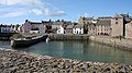
Alter Hafen
 (c) Bob Jones, CC BY-SA 2.0
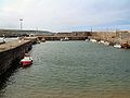
Neuer Hafen
 (c) Christopher Gillan, CC BY-SA 2.0
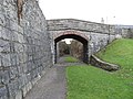
Ehemalige Eisenbahntrasse
 (c) Anne Burgess, CC BY-SA 2.0
Die St John's Episcopal Church aus dem Jahre 1840
Einzelnachweise
- ↑ Verzeichnis gälischer Ausdrücke
- ↑ a b c Eintrag im Gazetteer for Scotland
- ↑ Zensus 2011
- ↑ Eintrag zur Glenglassaugh-Brennerei bei maltmadness.com
Weblinks
- Eintrag zu Portsoy in Canmore, der Datenbank von Historic Environment Scotland (englisch).
Auf dieser Seite verwendete Medien

(c) Eric Gaba, NordNordWest, CC BY-SA 3.0
Positionskarte von Schottland, Vereinigtes Königreich

(c) Anne Burgess, CC BY-SA 2.0
St John's Episcopal Church The kirk was designed by James Ross and built in 1840. it is of rubble construction with sandstone corners. The north and south gables extend just far enough to hint at a cruciform floor plan. It is still in use as an episcopal church. More details at http://hsewsf.sedsh.gov.uk/hslive/hsstart?P_HBNUM=40280.

(c) Bob Jones, CC BY-SA 2.0
Portsoy New Harbour. The new harbour was constructed in 1825 due to ever increasing demand from the herring fishing fleet. The old harbour, built in 1693, still remains in use.

(c) Christopher Gillan, CC BY-SA 2.0
Old Railway Line, Portsoy The bridge spans the former railway line to the north of Portsoy Junction, being the old Harbour Branch. The area to the right is now a small park.

(c) Anne Burgess, CC BY-SA 2.0
Portsoy Old Harbour The buildings along the harbour front at Portsoy date mainly from the 18th century.
Photo of part of the Old Harbour, Portsoy, Banffshire, taken in May 2007 and scaled to size using GIMP 2.