Portlaw
| Portlaw Port Lách Portlaw | ||
|---|---|---|
| ||
| Koordinaten | 52° 17′ 16″ N, 7° 18′ 51″ W | |
| Basisdaten | ||
| Staat | Irland | |
| Provinz | Munster | |
| Grafschaft | Waterford | |
| ISO 3166-2 | IE-WD | |
| Höhe | 40 m | |
| Fläche | 1,3 km² | |
| Einwohner | 1881 (2022[1]) | |
| Dichte | 1.455,9 Ew./km² | |
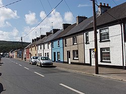
(c) David Hawgood, CC BY-SA 2.0 Main Street, Portlaw | ||
Portlaw (irisch Port Lách, auch Port Cládhach) ist eine Ortschaft im County Waterford im Süden der Republik Irland.
Lage
Portlaw liegt etwa fünfzehn Kilometer westnordwestlich von Waterford im Dreieck zwischen dem River Suir und dem River Clodiagh, der hier in den Suir mündet. Nördlich der Ortschaft liegt der Tower Hill Wood. Portlaw wird durch Bus Éireann von Waterford aus bedient.
Geschichte
Portlaw ist eine jüngere Gründung der Familie Malcomson im beginnenden 19. Jahrhundert. Die Quakerfamilie Malcomson errichteten eine erfolgreiche Baumwollspinnerei an diesem Ort, der planorientiert angelegt wurde. Strahlenartig wurde das Zentrum durch dreieckige Wohnareale umgeben. Rund um das Zentrum wurden Funktionsgebäude wie Postamt, Schule usw. errichtet. Um 1850 hatte die Ortschaft 4.350 Einwohner.
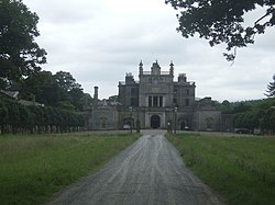
Außerhalb der Ortschaft befindet sich Curraghmore House. Es ist der Sitz des Marquess of Waterford. Das Georgianische Bauwerk wurde Mitte des 18. Jahrhunderts errichtet.
Weblinks
Einzelnachweise
- ↑ Census 2022. citypopulation.de, abgerufen am 11. Juli 2024.
Auf dieser Seite verwendete Medien
(c) David Hawgood, CC BY-SA 2.0
Main street of Portlaw, near to Port Lach, Clodiagh Bridge and Knockane, Waterford, Ireland. A terrace of houses with their front doors straight onto the street. There are bars and shops also in this street.
(c) John M, CC BY-SA 2.0
Back of Curraghmore House The back of the house, stables and servant quarters.
Autor/Urheber:
- Island_of_Ireland_location_map.svg: *Ireland_location_map.svg: NordNordWest
- Northern_Ireland_location_map.svg: NordNordWest
- Northern_Ireland_-_Counties.png: Maximilian Dörrbecker (Chumwa)
- derivative work: Rannpháirtí anaithnid (talk)
- derivative work: Mabuska (talk)
The island of Ireland, showing international border between Northern Ireland and Republic of Ireland, traditional provinces, traditional counties, and local authority areas in the Republic of Ireland and Northern Ireland.
(c) John M, CC BY-SA 2.0
St. Patrick's Roman Catholic Parish Church, Portlaw, County Waterford. The most remote and the largest of the town's churches.
(c) Karte: NordNordWest, Lizenz: Creative Commons by-sa-3.0 de
Positionskarte von Irland


