Portal:Mars/Mars

.jpg)


Der Mars ist, von der Sonne aus gesehen, der vierte Planet in unserem Sonnensystem und der äußere Nachbar der Erde. Sein Durchmesser ist mit knapp 6800 Kilometer etwa halb so groß wie der Durchmesser der Erde, sein Volumen beträgt gut ein Siebentel des Erdvolumens. Auffallend ist die Zweiteilung des Mars. Auf der nördlichen Halbkugel sind flache sand- und staubbedeckte Ebenen vorherrschend, die Namen wie Utopia Planitia oder Amazonis Planitia erhielten. Die südliche Halbkugel ist durchschnittlich sechs Kilometer höher als die nördliche und besteht aus geologisch älteren Formationen.
Wegen seiner orange- bis blutroten Farbe wurde der Planet nach dem römischen Kriegsgott Mars benannt und wird oft auch als der Rote Planet bezeichnet. Diese Färbung geht auf Eisen(III)-oxid-Staub (Rost) zurück, der sich auf der Oberfläche und in der Atmosphäre verteilt hat. Der Mars und seine fiktiven Bewohner sind Thema zahlreicher Romane und Verfilmungen.
Er besitzt zwei kleine, unregelmäßig geformte Monde: Phobos und Deimos (griechisch für Furcht und Schrecken).
Auf dieser Seite verwendete Medien
This mosaic of images from the Mast Camera (Mastcam) instrument on NASA's Curiosity Mars rover shows a series of sedimentary deposits in the Glenelg area of Gale Crater, from a perspective in Yellowknife Bay looking toward west-northwest.
Curiosity's science team has estimated that the "Cumberland" rock that the rover drilled for a sample of the Sheepbed mudstone deposit (at lower left in this scene) has been exposed at the surface for only about 80 million years. The estimate is based on amounts of certain gases that accumulate in a rock when it is close enough to the surface to be bombarded by cosmic rays. An explanation for that unexpectedly young exposure age comes from improved understanding of how the layers are eroding to expose underlying layers. The explanation proposes that the mudstone is being exposed by abrasion by windblown sand, indicated by arrows. The role for wind is strongly suggested by the undercutting of the Sheepbed layer below the Gillespie Lake sandstone.
The pattern here suggests that the Yellowknife Bay outcrop is being exposed by wind-driven scarp retreat -- the sideways erosion of a vertical face.
Mastcam took the images for this mosaic during the 188th Martian day, or sol, of Curiosity's work on Mars (Feb. 14, 2013). The 100-centimeter scale bars are about 39 inches long. A rock ledge about 8 inches (20 centimeters) high at the bottom of the scene -- where the Gillespie Lake layer meets the Sheepbed layer -- is about 50 feet (about 15 meters) from the rover's location when the images were taken. The midfield escarpment called "Point Lake" is about 118 feet (36 meters) from the rover's location. The outcrop on the near horizon, marked with a white X, is about 43 feet (13 meters) higher in elevation than the Sheepbed-Gillespie contact and at a distance of about 780 feet (240 meters).
The image has been white-balanced to show what the rocks would look like if ther were on Earth.
Malin Space Science Systems, San Diego, built and operates Mastcam. NASA's Jet Propulsion Laboratory manages the Mars Science Laboratory mission and the mission's Curiosity rover for NASA's Science Mission Directorate in Washington. The rover was designed, developed and assembled at JPL, a division of the California Institute of Technology in Pasadena.
For more about NASA's Curiosity mission, visit http://www.jpl.nasa.gov/msl, http://www.nasa.gov/mars, and http://marsprogram.jpl.nasa.gov/msl.A shiny-looking Martian rock is visible in this image taken by NASA's Mars rover Curiosity's Mast Camera (Mastcam) during the mission's 173rd Martian day, or sol (Jan. 30, 2013).
PIA17944: Curiosity's Color View of Martian Dune After Crossing It
http://photojournal.jpl.nasa.gov/catalog/PIA17944
This look back at a dune that NASA's Curiosity Mars rover drove across was taken by the rover's Mast Camera (Mastcam) during the 538th Martian day, or sol, of Curiosity's work on Mars (Feb. 9, 2014). The rover had driven over the dune three days earlier. For scale, the distance between the parallel wheel tracks is about 9 feet (2.7 meters). The dune is about 3 feet (1 meter) tall in the middle of its span across an opening called "Dingo Gap." This view is looking eastward.
The image has been white balanced to show what the Martian surface materials would look like if under the light of Earth's sky. A version with raw color, as recorded by the camera under Martian lighting conditions, is available as Figure 1.
NASA's Jet Propulsion Laboratory, a division of the California Institute of Technology, Pasadena, manages the Mars Science Laboratory Project for NASA's Science Mission Directorate, Washington. JPL designed and built the project's Curiosity rover. Malin Space Science Systems, San Diego, built and operates the rover's Mastcam.
More information about Curiosity is online at http://www.nasa.gov/msl and http://mars.jpl.nasa.gov/msl/.
Image Credit: NASA/JPL-Caltech/MSSS
As NASA's Mars Exploration Rover Spirit began collecting images for a 360-degree panorama of new terrain, the rover captured this view of a dark boulder with an interesting surface texture. The boulder sits about 40 centimeters (16 inches) tall on Martian sand about 5 meters (16 feet) away from Spirit. It is one of many dark, volcanic rock fragments—many pocked with rounded holes called vesicles—littering the slope of "Low Ridge." The rock surface facing the rover is similar in appearance to the surface texture on the outside of lava flows on Earth.
Spirit took this approximately true-color image with the panoramic camera on the rover's 810th sol, or Martian day, of exploring Mars (April 13, 2006), using the camera's 753-nanometer, 535-nanometer, and 432-nanometer filters.
Image Credit: NASA/JPL-Caltech/Cornell/NMMNHIn this image from NASA's Curiosity rover, a rock outcrop called Link pops out from a Martian surface that is elsewhere blanketed by reddish-brown dust. The fractured Link outcrop has blocks of exposed, clean surfaces. Rounded gravel fragments, or clasts, up to a couple inches (few centimeters) in size are in a matrix of white material. Many gravel-sized rocks have eroded out of the outcrop onto the surface, particularly in the left portion of the frame. The outcrop characteristics are consistent with a sedimentary conglomerate, or a rock that was formed by the deposition of water and is composed of many smaller rounded rocks cemented together. Water transport is the only process capable of producing the rounded shape of clasts of this size.
PIA17062: Remnants of Ancient Streambed on Mars (White-Balanced View)
http://photojournal.jpl.nasa.gov/catalog/PIA17062
NASA's Curiosity rover found evidence for an ancient, flowing stream on Mars at a few sites, including the rock outcrop pictured here, which the science team has named "Hottah" after Hottah Lake in Canada's Northwest Territories. It may look like a broken sidewalk, but this geological feature on Mars is actually exposed bedrock made up of smaller fragments cemented together, or what geologists call a sedimentary conglomerate. Scientists theorize that the bedrock was disrupted in the past, giving it the titled angle, most likely via impacts from meteorites.
NASA's Mars Science Laboratory (MSL) Curiosity rover found evidence for ancient, water-transported sediment on Mars at a few sites, including the rock outcrop pictured here, named "Hottah." Rounded pebbles within this sedimentary conglomerate indicate sustained abrasion of rock fragments within water flows that crossed Gale Crater.
The key evidence for the ancient stream comes from the size and rounded shape of the gravel in and around the bedrock. Hottah has pieces of gravel embedded in it, called clasts, up to a couple inches (few centimeters) in size and located within a matrix of sand-sized material. Some of the clasts are round in shape, leading the science team to conclude they were transported by a vigorous flow of water. The grains are too large to have been moved by wind. Erosion of the outcrop results in gravel clasts that protrude from the outcrop and ultimately fall onto the ground, creating the gravel pile in the left foreground. The scale bar at lower right is 5 centimeters (2 inches).
This view of Hottah is a mosaic of images taken by the right (telephoto-lens) camera of the Mast Camera instrument (Mastcam) on Curiosity during the 39th Martian day, or sol, of the rover's work on Mars (Sept. 14, 2012 PDT/Sept. 15 GMT). It has been enhanced for presentation in white-balanced color, which yields a view as if the rock were seen under outdoor lighting conditions on Earth, which is useful for scientists to distinguish rocks by color in familiar lighting. A "raw color" view of Hottah, showing the colors as recorded by the camera on Mars, is at PIA16156. A stereo view is at PIA16223.
Malin Space Science Systems, San Diego, built and operates Mastcam. NASA's Jet Propulsion Laboratory manages the Mars Science Laboratory mission and the mission's Curiosity rover for NASA's Science Mission Directorate in Washington. The rover was designed, developed and assembled at JPL, a division of the California Institute of Technology in Pasadena.
For more about NASA's Curiosity mission, visit http://www.jpl.nasa.gov/msl, http://www.nasa.gov/mars, and http://marsprogram.jpl.nasa.gov/msl.PIA16452: A Martian Rock Called 'Rocknest 3'
http://photojournal.jpl.nasa.gov/catalog/PIA16452 http://photojournal.jpl.nasa.gov/jpeg/PIA16452.jpg
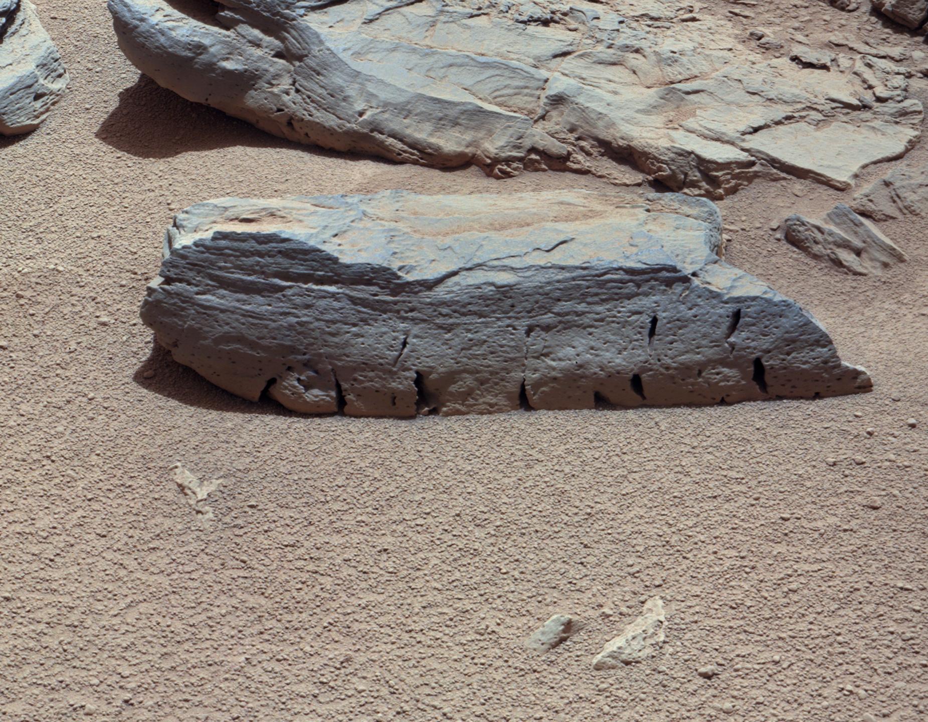
Target Name: Mars Is a satellite of: Sol (our sun) Mission: Mars Science Laboratory (MSL) Spacecraft: Curiosity Instrument: Mastcam Product Size: 1851 x 1440 pixels (width x height) Produced By: Malin Space Science Systems Full-Res TIFF: PIA16452.tif (7.999 MB) Full-Res JPEG: PIA16452.jpg (538.1 kB)
Click on the image above to download a moderately sized image in JPEG format (possibly reduced in size from original) Original Caption Released with Image:
Figure 1 Figure 2 Click on an individual image for larger views
This view of a Martian rock called "Rocknest 3" combines four images taken by the right-eye camera of the Mast Camera (Mastcam) instrument, which has a telephoto, 100-millimeter-focal-length lens. The component images were taken a few minutes after Martian noon on the 59th Martian day, or sol, of Curiosity's operations on Mars (evening of Oct. 5, 2012, PDT). Rocknest 3 is a rock approximately 15 inches (40 centimeters) long and 4 inches (10 centimeters) tall, next to the "Rocknest" patch of windblown dust and sand where Curiosity scooped and analyzed soil samples. The Mastcam was about 13 feet (4 meters) from the rock when the component images were taken, providing an image scale of about 0.01 inch (0.3 millimeter) per pixel.
The image has been white-balanced to show what the rock would look like if it were on Earth. Figure 1 is a raw-color version, showing what the rock looks like on Mars to the camera. Figure 2 includes annotation indicating the portion of Rocknest 3 covered in Sol 57 imaging by Curiosity's Chemistry and Camera (ChemCam) instrument at PIA16451.
JPL, a division of the California Institute of Technology, Pasadena, manages the Mars Science Laboratory Project for NASA's Science Mission Directorate, Washington. JPL designed and built the rover.
More information about Curiosity is online at http://www.nasa.gov/msl and http://mars.jpl.nasa.gov/msl/.
Image Credit: NASA/JPL-Caltech/Malin Space Science Systems
Image Addition Date:
2012-11-26