Port Stephens Council
| Port Stephens | |
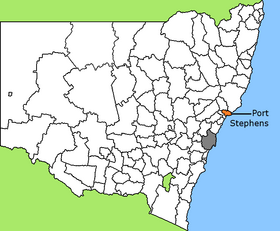
 Lage des Port Stephens Council in New South Wales (Sydney in grau) | |
| Gliederung | |
| Staat: | |
| Bundesstaat: | |
| Verwaltungssitz: | Raymond Terrace |
| Daten und Zahlen | |
| Fläche: | 858,4 km² |
| Einwohner: | 75.276 (2021) [1] |
| Bevölkerungsdichte: | 88 Einwohner je km² |
| Wards: | 3 |
Koordinaten: 32° 44′ S, 151° 57′ O Port Stephens ist ein lokales Verwaltungsgebiet (LGA) im australischen Bundesstaat New South Wales. Das Gebiet ist 858,4 km² groß und hat etwa 75.300 Einwohner.[1]
Port Stephens liegt an der Ostküste des Staates 200 km nordöstlich der Metropole Sydney. Das Gebiet umfasst 45 Ortsteile und Ortschaften: Anna Bay, Balickera, Boat Harbour, Bobs Farm, Brandy Hill, Butterwick, Campvale, Corlette, Duns Creek, Eagleton, Fern Bay, Ferodale, Fingal Bay, Fishermans Bay, Heatherbrae, Hinton, Kings Hill, Lemon Tree Passage, Mallabula, Medowie, Nelson Bay, Nelsons Plains, One Mile, Osterley, Oyster Cove, Raymond Terrace, Salamander Bay, Salt Ash, Seaham, East Seaham, Shoal Bay, Soldiers Point, Swan Bay, Tanilba Bay, Taylors Beach, Tilligerry Creek, Tomago, Twelve Mile Creek, Wallalong, Williamtown und Teile von Fullerton Cove, Glen Oak, Karuah, Port Stephens und Woodville.[2] Der Verwaltungssitz des Councils befindet sich in der Stadt Raymond Terrace am Westrand der LGA, wo etwa 14.100 Einwohner leben.[3]
Verwaltung
Der Council von Port Stephens hat zwölf Mitglieder, die von den Bewohnern der drei Wards gewählt werden (je drei aus dem Central, dem East und dem West Ward). Diese drei Bezirke sind unabhängig von den Ortschaften festgelegt. Der Vorsitzende und Mayor (Bürgermeister) des Councils wird zusätzlich von allen Bewohnern gewählt.
Bis 2008 wurden noch vier Councillor pro Ward gewählt. Der Vorsitzende rekrutierte sich aus den zwölf Gewählten.[4]
Quellen
- ↑ a b Port Stephens. 2021 Census Quickstat. Australian Bureau of Statistics, 28. Juni 2022, abgerufen am 23. Oktober 2022 (englisch).
- ↑ Suburb and LGA PercentageArea, Office of Local Government NSW, 1. Oktober 2021
- ↑ Raymond Terrace. 2021 Census Quickstat. Australian Bureau of Statistics, 28. Juni 2022, abgerufen am 23. Oktober 2022 (englisch).
- ↑ Wahlen in Port Stephens: [pastvtr.elections.nsw.gov.au/LGE2008/result.Port_Stephens.council3a00.html 2008] – 2012 – 2017 – 2021; Quelle: NSW Electoral Commission
Weblinks
- Offizielle Seite des Port Stephens Council
- Community Profile ( vom 31. August 2007 im Internet Archive)
Auf dieser Seite verwendete Medien
Flag of Australia, when congruence with this colour chart is required (i.e. when a "less bright" version is needed).
See Flag of Australia.svg for main file information.Map of New South Wales/Australia, LGA of Port Stephens highlighted


