Plouharnel
| Plouharnel | ||
|---|---|---|
| ||
| Staat | Frankreich | |
| Region | Bretagne | |
| Département (Nr.) | Morbihan (56) | |
| Arrondissement | Lorient | |
| Kanton | Quiberon | |
| Gemeindeverband | Auray Quiberon Terre Atlantique | |
| Koordinaten | 47° 36′ N, 3° 7′ W | |
| Höhe | 0–33 m | |
| Fläche | 18,32 km² | |
| Einwohner | 2.240 (1. Januar 2020) | |
| Bevölkerungsdichte | 122 Einw./km² | |
| Postleitzahl | 56340 | |
| INSEE-Code | 56168 | |
 Kapelle Sainte-Barbe | ||
Plouharnel ist eine französische Gemeinde mit 2240 Einwohnern (Stand 1. Januar 2020) im Département Morbihan in der Region Bretagne. Sie liegt im Norden der Bucht von Quiberon, drei Kilometer von Carnac entfernt. Vannes, der Sitz der Präfektur, liegt knappe 40 Kilometer östlich. Bei Plouharnel befindet sich das größte Dünengebiet Frankreichs.
Der Bahnhof Plouharnel-Carnac liegt an der Bahnstrecke Auray–Quiberon. Die Straßenbahn La Trinité–Étel führte bis 1935 durch den Ort.
Am 16. Juli 1795 fand hier das Gefecht bei Plouharnel statt.
Bevölkerungsentwicklung
| Jahr | 1962 | 1968 | 1975 | 1982 | 1990 | 1999 | 2008 | 2019 |
|---|---|---|---|---|---|---|---|---|
| Einwohner | 1478 | 1487 | 1492 | 1525 | 1653 | 1699 | 1962 | 2214 |
Sehenswürdigkeiten
- Kapelle Sainte-Barbe
- Dolmen von Rondossec an der Rue Hoche in Plouharnel

Persönlichkeiten
- François Person (1890–1938), römisch-katholischer Priester, Apostolischer Vikar der Elfenbeinküste
Literatur
- Le Patrimoine des Communes du Morbihan. Flohic Editions, Band 2, Paris 1996, ISBN 2-84234-009-4, S. 845–847.
Weblinks
- Tourismusbüro Plouharnel (französisch, englisch, deutsch)
Auf dieser Seite verwendete Medien
(c) Karte: NordNordWest, Lizenz: Creative Commons by-sa-3.0 de
Positionskarte von Frankreich mit Regionen und Départements
Autor/Urheber: Erwan Corre, Lizenz: CC BY-SA 4.0
Une jolie chapelle typiquement bretonne érigée au XVIe siècle qui trône avec splendeur dans le magnifique hameau de Sainte-Barbe :
"La chapelle est située dans un hameau longtemps appelé « Pen er Bloé », autrement dit « le village du bout de la paroisse »[1]".
Cette chapelle de forme rectangulaire présente des contreforts à retraits et pinacles, crosses et choux rampants. Elle possède un clocher carré au-dessus de la porte occidentale encadrée de clochetons. Deux statues incomplètes surmontent les contreforts d'angle de la façade (elles auraient été « décapitées » lors de la période de la Révolution)[2].(c) Photo: Myrabella / Wikimedia Commons, CC BY-SA 3.0
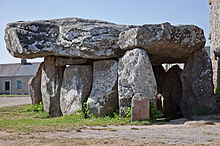
Crucuno dolmen, in Plouharnel (Morbihan, Brittany, France). This is thought to be a burial chamber. It has a 40 ton cap stone on the top. It is dated 4000BC. This was originally located in the 19th century by reading engravings of a very long passage. This information is noted in a sign posted at the site itself.
Autor/Urheber:
| This illustration was made by Peter Potrowl.
Please credit this with : © Peter Potrowl in the immediate vicinity of the image. A link to my website sitemai.eu would be much appreciated but isn't mandatory. An email to
Do not copy this image illegally by ignoring the terms of the license below, as it is not in the public domain.
If you would like special permission to use, license, or purchase the image please contact me More free pictures in my website. Donations are accepted here and here. |
Saint-Armel's church in Plouharnel (Morbihan, Bretagne, France).


