Pinal County
 | |
| Verwaltung | |
|---|---|
| US-Bundesstaat: | Arizona |
| Verwaltungssitz: | Florence |
| Gründung: | 1875 |
| Demographie | |
| Einwohner: | 425.264 (Stand: 2020) |
| Bevölkerungsdichte: | 30,57 Einwohner/km² |
| Geographie | |
| Fläche gesamt: | 13.919 km² |
| Wasserfläche: | 10 km² |
| Karte | |
 | |
| Website: www.pinal.gov | |
Pinal County[2] ist ein County in Arizona der Vereinigten Staaten. Das Pinal County ist Teil der Metropolregion Phoenix.
Geschichte
Das County wurde am 1. Februar 1875 gebildet.[3]

107 Bauwerke, Stätten und historische Bezirke (Historic Districts) des Countys sind im National Register of Historic Places („Nationales Verzeichnis historischer Orte“; NRHP) eingetragen (Stand 4. Februar 2022), darunter hat das Hohokam Pima National Monument den Status eines National Historic Landmarks („Nationales historisches Wahrzeichen“).[5]
Demografische Daten
| Bevölkerungswachstum | |||
|---|---|---|---|
| Census | Einwohner | ± rel. | |
| 1880 | 3.440 | — | |
| 1890 | 4.251 | 23,6 % | |
| 1900 | 7.779 | 83 % | |
| 1910 | 9.045 | 16,3 % | |
| 1920 | 16.130 | 78,3 % | |
| 1930 | 22.081 | 36,9 % | |
| 1940 | 28.841 | 30,6 % | |
| 1950 | 43.191 | 49,8 % | |
| 1960 | 62.673 | 45,1 % | |
| 1970 | 67.916 | 8,4 % | |
| 1980 | 90.918 | 33,9 % | |
| 1990 | 116.379 | 28 % | |
| 2000 | 179.727 | 54,4 % | |
| 2010 | 375.770 | 109,1 % | |
| 2020 | 425.264 | 13,2 % | |
1900–1990[6] 2000[7] 2010[8] 2020[9] | |||


Nach der Volkszählung im Jahr 2010 lebten im Pinal County 375.770 Menschen. Es gab 61.364 Haushalte und 45.225 Familien. Die Bevölkerungsdichte betrug 13 Einwohner pro Quadratkilometer. Ethnisch betrachtet setzte sich die Bevölkerung zusammen aus 70,42 Prozent Weißen, 2,76 Prozent Afroamerikanern, 7,81 Prozent amerikanischen Ureinwohnern, 0,60 Prozent Asiaten, 0,08 Prozent Bewohnern aus dem pazifischen Inselraum und 15,66 Prozent aus anderen ethnischen Gruppen; 2,67 Prozent stammten von zwei oder mehr Ethnien ab. 29,86 Prozent der Bevölkerung waren spanischer oder lateinamerikanischer Abstammung.
Von den 61.364 Haushalten hatten 29,8 Prozent Kinder und Jugendliche unter 18 Jahre, die bei ihnen lebten. 56,9 Prozent waren verheiratete, zusammenlebende Paare, 11,5 Prozent waren allein erziehende Mütter, 26,3 Prozent waren keine Familien. 21,1 Prozent waren Singlehaushalte und in 9,2 Prozent lebten Menschen im Alter von 65 Jahren oder darüber. Die Durchschnittshaushaltsgröße betrug 2,68 und die durchschnittliche Familiengröße lag bei 3,09 Personen.
Auf das gesamte County bezogen setzte sich die Bevölkerung zusammen aus 25,1 Prozent Einwohnern unter 18 Jahren, 8,7 Prozent zwischen 18 und 24 Jahren, 27,3 Prozent zwischen 25 und 44 Jahren, 22,7 Prozent zwischen 45 und 64 Jahren und 16,2 Prozent waren 65 Jahre alt oder darüber. Das Durchschnittsalter betrug 37 Jahre. Auf 100 weibliche Personen kamen 114,2 männliche Personen, auf 100 Frauen im Alter ab 18 Jahren kamen statistisch 117,0 Männer.
Das jährliche Durchschnittseinkommen eines Haushalts betrug 35.856 USD, das Durchschnittseinkommen der Familien betrug 39.548 USD. Männer hatten ein Durchschnittseinkommen von 31.544 USD, Frauen 23.726 USD. Das Prokopfeinkommen betrug 16.025 USD. 16,9 Prozent der Bevölkerung und 12,1 Prozent der Familien lebten unterhalb der Armutsgrenze. 25,5 Prozent davon waren unter 18 Jahre und 8,7 Prozent waren 65 Jahre oder älter.
Orte im Pinal County
Im Pinal County liegen 12 Gemeinden, davon fünf Cities und sieben Towns. Zu Statistikzwecken führt das U.S. Census Bureau 32 Census-designated places, die dem County unterstellt sind und keine Selbstverwaltung besitzen. Diese sind wie die Unincorporated Communities gemeindefreies Gebiet.
|
|
|
|
|
|
andere Unincorporated Communities
|
|
|
|
|
Reservate und Parks
|
|
Weblinks
Einzelnachweise
- ↑ Pinal County Courthouse im National Register Information System. National Park Service, abgerufen am 7. Mai 2020.
- ↑ Pinal County. In: Geographic Names Information System. United States Geological Survey, United States Department of the Interior, 27. Juni 1984, abgerufen am 31. August 2023 (englisch).
- ↑ Charles Curry Aiken, Joseph Nathan Kane: The American Counties: Origins of County Names, Dates of Creation, Area, and Population Data, 1950–2010. 6. Auflage. Scarecrow Press, Lanham 2013, ISBN 978-0-8108-8762-6, S. 243.
- ↑ Listing of National Historic Landmarks by State: Arizona. National Park Service, abgerufen am 6. Mai 2020.
- ↑ Suchmaske Datenbank im National Register Information System. National Park Service, abgerufen am 4. Februar 2022.
Weekly List im National Register Information System. National Park Service, abgerufen am 4. Februar 2022.
Listing of National Historic Landmarks by State: Arizona. National Park Service, abgerufen am 4. Februar 2022. - ↑ Auszug aus Census.gov. Abgerufen am 28. Februar 2011.
- ↑ Auszug aus factfinder.census.gov (Seite nicht mehr abrufbar, festgestellt im Dezember 2022. Suche in Webarchiven) Info: Der Link wurde automatisch als defekt markiert. Bitte prüfe den Link gemäß Anleitung und entferne dann diesen Hinweis. Abgerufen am 28. Februar 2011.
- ↑ Auszug aus census.gov ( des vom 16. Juli 2011 auf WebCite) Info: Der Archivlink wurde automatisch eingesetzt und noch nicht geprüft. Bitte prüfe Original- und Archivlink gemäß Anleitung und entferne dann diesen Hinweis. Abgerufen am 31. März 2012.
- ↑ Eintrag bei Census.gov. Abgerufen am 4. Februar 2022.
Koordinaten: 32° 59′ N, 111° 20′ W
Auf dieser Seite verwendete Medien
Autor/Urheber: BruceandLetty, Lizenz: CC BY 2.0
Hohokam Pima National Monument — a Hohokam cultural site, in Pinal County, Arizona.
- Currently closed to the public.
Autor/Urheber:
- real name: Artur Jan Fijałkowski
- pl.wiki: WarX
- commons: WarX
- mail: [1]
- jabber: WarX@jabber.org
- irc: [2]
- software: own perl scripts
Age pyramid for Pinal County, Arizona, United States of America, based on census 2000 data
Autor/Urheber: Shereth, Lizenz: CC BY-SA 3.0
Second Pinal county courthouse in Florence, Arizona
Autor/Urheber: Maureen Kirk-Detberner from Arizona, USA, Lizenz: CC BY-SA 2.0
View towards the San Pedro River Valley and the Galiuro Mountians, south of San Manuel Arizona.
Autor/Urheber: Alan English CPA from Scottsdale, Arizona 85254, USA, Lizenz: CC BY-SA 2.0
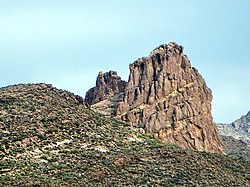
This is the view looking northeast at Miner's Needle from the Bluff Spring Trail. This area figures prominently in the legends of gold in the Supes. The Lost Dutchman's Mine is thought to be near here.
I hiked the Charleyboy Duece Loop - the hike shown as Charlebois Loop II in "Hiker's Guide to the Superstition Wilderness" by Jack Stewart and Liz Carlson.
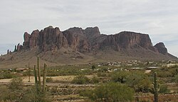
From Wikipedia: "The Superstition Mountains, popularly referred to as "The Superstitions" or "The Supes", are a range of mountains in Arizona located to the east of the Phoenix metropolitan area. They are anchored by Superstition Mountain, a large mountain that is a popular recreation destination for residents of the Phoenix, Arizona area.
The mountain range is in the federally-designated Superstition Wilderness Area, and includes a variety of natural features in addition to the mountain that is its namesake. Weaver's Needle, a prominent landmark and rock climbing destination set behind and to the east of Superstition Mountain, is a tall erosional remnant [1] that plays a significant role in the legend of the Lost Dutchman's Gold Mine. Peralta Canyon, on the northeast side of Superstition Mountain, contains a popular trail that leads up to Freemont Saddle, which provides a very picturesque view of Weaver's Needle. Miner's Needle is another prominent formation in the wilderness and a popular hiking destination."ᎡᏩᏐᎾ ᎦᏓᏘ


