Pickersgill Harbour
| Pickersgill Harbour | ||
| Geographische Lage | ||
| Koordinaten | 45° 48′ S, 166° 35′ O | |
| Region-ISO | NZ-STL | |
| Land | Neuseeland | |
| Region | Southland | |
| Meereszugang | Tamatea / Dusky Sound, Tasmansee | |
| Daten zum Naturhafen | ||
| Hafeneingang | 575 m breit | |
| Länge | rund 0,77 km | |
| Breite | max. 0,6 km | |
| Küstenlänge | rund 3,0 km | |
| Zuflüsse | Einige wenige kleine Streams (Bäche) | |
| Inseln | Crayfish Island | |
| Fotografie des Naturhafens | ||
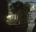
 Szene im Pickersgill Harbour, Dusky Bay, New Zealand, William Hodges, gemalt zwischen 1773 und 1776 | ||
Pickersgill Harbour ist ein Naturhafen im südwestlichen Teil des Tamatea / Dusky Sound in der Region Southland auf der Südinsel von Neuseeland.
Namensherkunft
Der Naturhafen erhielt seinen Namen, als am 11. April 1773 auf James Cooks zweiter Südseereise die beiden Schiffe Resolution und Adventure in der Bucht vor Anker gingen, nachdem zuvor der dritte Leutnant der Resolution, Richard Pickersgill, die Bucht als einen sicheren Ankerort befunden hatte. Ihm zu Ehren wurde der Naturhafen Pickersgill Harbour genannt.[1]
Geographie
Der Pickersgill Harbour befindet sich rund 4 km südlich von Resolution Island im südlichen Teil des Tamatea / Dusky Sound.[2] Der nach Nordosten hin weit geöffnete Naturhafen besitzt eine Länge von rund 770 m und misst an seiner breitesten Stelle rund 600 m. Der größere der beiden Hafeneingänge ist rund 575 m breit und der nach Norden ausgerichtete Eingang misst rund 30 m in der Breite. Dazwischen liegt die rund 410 m lange Insel Crayfish Island. Die Küstenlänge des Gewässers erstreckt sich über rund 3 km.[3] Der Naturhafen wird nur von einigen wenigen Bächen gespeist, von denen der Cook Stream dem auf 33 m Höhe gelegenen Lake Forster entspringt.[2]
Der im unbewohnten Gebiet liegende Naturhafen gehört zum Fiordland National Park und administrativ zum Southland District der Region Southland.
Astronomer’s Point
Während sich die Crews der beiden Schiffe Resolution und Adventure 1773 bei ihrem mehrwöchigen Aufenthalt im Pickersgill Harbour von der anstrengenden Seereise durch die arktischen Gewässer erholten und die Resolution repariert wurde, gab Kapitän Cook den Auftrag, die genaue Position ihres Standorts anhand der Sterne zu bestimmen. Dazu wurde an Land die Fläche von einem Acre Wald gerodet und darauf ein Observatorium eingerichtet, das unter anderem dazu diente, die genaue Position Neuseelands zu ermitteln. Während dieser Zeit entstand auch die Karte (s. u.) über den Tamatea / Dusky Sound und den angrenzenden Inseln und Gebiete. Der Ort an Land ist heute als Astronomer’s Point bekannt.[4]
Auf einem Felsen des Ortes wurde im Jahr 1963 von den beiden Brüdern A. Charles und Neil C. Begg eine Plakette aus Bronze angebracht, die auf diesen historischen Ort verweisen sollte. Die Brüder veröffentlichten 1966 ihr Buch mit dem Titel: „Dusky Bay – In the Steps of Captain Cook“, in dem ein Foto von ihnen zu sehen ist, wie sie die Plakette an dem Felsen befestigen.[5]
William Hodges’ Gemälde
Mit an Bord während Cooks zweiter Südseereise war der englische Maler William Hodges (1744–1797). Eines seiner Werke ist im National Maritime Museum im Londoner Stadtteil Greenwich zu besichtigen. Die von ihm gemalte Szene zeigt die Resolution am Ufer des Pickersgill Harbour liegend (s. Foto rechts in der Infobox).[1]
Abbildung der Landkarte
Siehe auch
Einzelnachweise
- ↑ a b View in Pickersgill Harbour, Dusky Bay, New Zealands. Royal Museums Greenwich, abgerufen am 31. Januar 2018 (englisch).
- ↑ a b Topo250 maps. Land Information New Zealand, abgerufen am 31. Januar 2018 (englisch).
- ↑ Koordinaten und Längenbestimmungen wurden zum Teil über Google Earth Version 7.1.8.3036 am 31. Januar 2018 vorgenommen.
- ↑ Historic Astronomer's Point. Department of Conservation, abgerufen am 31. Januar 2018 (englisch).
- ↑ Pickersgill Harbour, Dusky Bay, New Zealand. Captain Cook Society, abgerufen am 1. Februar 2018 (englisch).
Auf dieser Seite verwendete Medien
Sketch of Dusky Bay in New Zealand; 1773.Single sheet. Engr. Scale: [1:126 720 (1" = 2miles)]. Cartographic Note: Ungraduated. North at 31 degrees. Few soundings. Scale in miles. Contents Note: Inset: Pickersgill Harbour.
Plate XIII from Cook's Voyage Towards the South Pole.
'View in Pickersgill Harbour, Dusky Bay, New Zealand'
Hodges' paintings of the Pacific are vivid records of British exploration. He was appointed by the Admiralty to record the places discovered on Cook's second voyage, undertaken in the 'Resolution' and 'Adventure', 1772-75. This was primarily in the form of drawings, with some oil sketches, many later converted to engravings in the official voyage account. He also completed large oil paintings for exhibition in London on his return, which exercised lasting influence on European ideas of the Pacific. The National Maritime Museum holds 26 oils relating to the voyage of which 24 were either painted for or acquired by the Admiralty.
Cook's main purpose on this expedition was to locate, if possible, the much talked-of but unknown Southern Continent and further expand knowledge of the central Pacific islands, in which Hodges' records of coastal profiles were in part important for navigational reasons.
This painting depicts the 'Resolution' moored alongside the shore in Pickersgill Harbour, Dusky Bay, New Zealand, where Cook’s two ships arrived on 11 April 1773. The harbour was named after Richard Pickersgill, the 'Resolution's' third lieutenant, who observed its safety and convenience as an anchorage, made possible through the deep water close in to the shore. The area is shown thickly wooded with dense, cool temperate rain forest and Hodges has carefully delineated the botanical features of the exotic vegetation, ferns, creepers and giant forest trees. As Cook noted in his account, nature conveniently provided a large tree growing horizontally over the water that was transformed into a gangplank. Hodges has chosen this natural gangway as the subject of his painting as seen from the ship, as it reached the ship's gunwale. A heavy tackle from one of 'Resolution's' yardarms is shown both securing the ship to the tree and perhaps also supporting the flimsy bridge. Hodges has also created an unusual compositional device, using a section of the ship's hull in silhouette. This implies his vantage point as being either from the port quarter-gallery window of the cabin, looking forward, or given the low angle even from a boat under the stern.
The sunlight shining through the trees highlights the clearing that the 'Resolution's' astronomer, William Wales, and his assistants created in the forest to pitch their special observatory tent and provide a clear sky view for astronomical observation. The tent can be glimpsed in the clearing with some clothes hanging out to dry, taking advantage of the good weather. One of the sailors is depicted as he returns aboard from a smoking fire in the background on the left. He has possibly used the fire to cook a large blue fish, which he is holding his hand as he crosses the gangway. The image concentrates on the profound beauty of Dusky Bay, where Hodges spent a considerable amount of time painting and drawing. He has observed the sense of loneliness, mystery and grandeur that pervaded the place, in this romantic evocation of an aesthetic response to nature.
Dusky Bay proved a recurrent subject for Hodges, featuring also in BHC2371, BHC1907 and BHC1908. This was probably due to the sense of paradise that it evoked, as the first landfall made by Cook’s ships in New Zealand after an arduous sweep of the Antarctic Ice. X-rays of this painting made in 2004 revealed that Hodges had attempted to capture the extreme Antarctic scenery, with two icebergs clearly visible in a previous composition beneath ‘Pickersgill Harbour’. The unusually shaped iceberg to the left matches a drawing by voyage naturalist George Forster, and description by voyage Astronomer William Wales as like ‘an old square castle, one end of which had fallen into Ruins, and it had a Hole quite through it whose roof so exactly resembled the Gothic arch of an old Postern Gateway that I believe it would have puzzled an Architect to have built it truer’.
Autor/Urheber:
- New_Zealand_location_map.svg: NordNordWest
- derivative work: Виктор В (talk)
Positionskarte von Neuseeland


