Pica (Chile)
Koordinaten: 20° 29′ S, 69° 20′ W
Pica ist ein chilenischer Ort und eine Gemeinde in der Provinz Tamarugal, I Región de Tarapacá.
Der Ort liegt in einer Oase inmitten der Atacama-Wüste. Pica ist berühmt für seine Zitronen. Es gibt eine heiße Quelle mit einer Oberflächentemperatur von 40 °C. Der Ort Pica hat 4674 Einwohner, die Gemeinde 6178.[1]
 Iglesia San Andrés.
 (c) Bachelot Pierre J-P, CC BY-SA 3.0Hauptplatz
 (c) Bachelot Pierre J-P, CC BY-SA 3.0La Cocha Resbaladero
 (c) Bachelot Pierre J-P, CC BY-SA 3.0Panorama
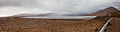 (c) Diego Delso, CC BY-SA 4.0Collahuasi Bergbau
Weblinks
Commons: Pica (Chile) – Sammlung von Bildern, Videos und Audiodateien
Einzelnachweise
- ↑ Mapa Interactivo - Region de Tarapacá. Instituto Nacional de Estadísticas, abgerufen am 11. Januar 2014 (über den Reiter "ocultar regiones"/"I Región" auf Pica (unten links) klicken).
Auf dieser Seite verwendete Medien

Pica, Chili, la Cocha Resbaladero.jpg
(c) Bachelot Pierre J-P, CC BY-SA 3.0
Pica,la Cocha Resbaladero, municipality of Pica, Iquique province, region I, Chile
(c) Bachelot Pierre J-P, CC BY-SA 3.0
Pica,la Cocha Resbaladero, municipality of Pica, Iquique province, region I, Chile

Pica, Chili.jpg
(c) Bachelot Pierre J-P, CC BY-SA 3.0
Pica oasis panoramic view, municipality of Pica Iquique province, region I, Chile
(c) Bachelot Pierre J-P, CC BY-SA 3.0
Pica oasis panoramic view, municipality of Pica Iquique province, region I, Chile

Mina de Collahuasi, Chile, 2016-02-10, DD 31-33 PAN.JPG
(c) Diego Delso, CC BY-SA 4.0
Collahuasi Mine, Tarapacá Region, Chile
(c) Diego Delso, CC BY-SA 4.0
Collahuasi Mine, Tarapacá Region, Chile

Pica Chili la place principale.jpg
(c) Bachelot Pierre J-P, CC BY-SA 3.0
la place principale et l'église San Andrès à Pica, commune de Pica, province d'Iquique, région I, Chili
(c) Bachelot Pierre J-P, CC BY-SA 3.0
la place principale et l'église San Andrès à Pica, commune de Pica, province d'Iquique, région I, Chili

Iglesia San Andres Pica.jpg
Autor/Urheber: The Guru, Lizenz: CC BY-SA 4.0
Iglesia de San Andrés en Pica (Chile)
Autor/Urheber: The Guru, Lizenz: CC BY-SA 4.0
Iglesia de San Andrés en Pica (Chile)

South America laea location map.svg
Autor/Urheber: Uwe Dedering, Lizenz: CC BY-SA 3.0
Location map of SouthAmerica with borders.
Autor/Urheber: Uwe Dedering, Lizenz: CC BY-SA 3.0
Location map of SouthAmerica with borders.
- Projection: Lambert azimuthal equal-area projection.
- Area of interest:
- N: 25.0° N
- S: -60.0° N
- W: -90.0° E
- E: -30.0° E
- Projection center:
- NS: -17.5° N
- WE: -60.0° E
- GMT projection: -JA-60/-17.5/20.0c
- GMT region: -R-111.71735564517205/-55.20793284837989/-29.863824948966922/25.8980715779886r
- GMT region for grdcut: -R-112.0/-63.0/-8.0/26.0r
- Made with Natural Earth. Free vector and raster map data @ naturalearthdata.com.