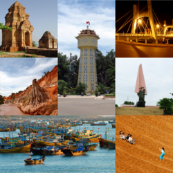
Phan Thiết
| Phan Thiết | |
|---|---|
| Basisdaten | |
| Staat: | |
| Landesteil: | Südost |
| Provinz: | Bình Thuận |
| ISO 3166-2:VN: | VN-40 |
| Koordinaten: | 10° 56′ N, 108° 6′ O |
| Bevölkerung | |
| Einwohner der Stadt: | 350.000 (2011) |
| Weitere Informationen | |
| Gründung: | 1898 |
| Zeitzone: | UTC+7:00 |
Phan Thiết ist eine Stadt in der Provinz Bình Thuận im Südosten von Vietnam mit etwa 350.000 Einwohnern (2011). Der Stadtbereich ist 206 Quadratkilometer groß und umfasst 15 Stadtteile und ein Dorf. Phan Thiết befindet sich ca. 200 km nordöstlich von Hồ-Chí-Minh-Stadt an der Spitze einer Halbinsel.
Bilder
- Phan Thiết von oben
- Phan Thiết
- © Mosbatho, CC BY 4.0Das größte Walskelett Vietnams im Vạn Thủy Tú-Tempel, ein Beispiel für vietnamesische Walverehrunge in den vietnamesischen Volksreligion
Auf dieser Seite verwendete Medien
(c) Nguyễn Đông Sơn at vi.wikipedia, CC BY-SA 3.0
Phan Thiết City and Cà Ty River flows through.
Autor/Urheber: Uwe Dedering, Lizenz: CC BY-SA 3.0
Location map of Vietnam.
Equirectangular projection. Strechted by 104 %. Geographic limits of the map:
- N: 24.0° N
- S: 8.0° N
- W: 101.8° E
- E: 110.3° E
Paracel Islands (map between). Equirectangular projection. Stretched by 52%. Geographic limits of the map:
- N: 17°15′ N
- S: 15°45′ N
- W: 111°00′ E
- E: 113°00′ E
Spratly Islands (map below). Equirectangular projection. Stretched by 41.6%. Geographic limits of the map:
- N: 12°00' N
- S: 6°12' N
- W: 111°30' E
- E: 117°20' E
© Mosbatho, CC BY 4.0
Skelett eines Balaenoptera physalus im Van Thuy Tu Temple (Dinh Vạn Thủy Tú) in Phan Thiết, Vietnam.


