Pentland Hills
| Pentland Hills | ||
|---|---|---|
 (c) Richard Webb, CC BY-SA 2.0 Blick von Mauldslie Hill (Moorfoot Hills) auf die Nordostflanke der Pentland Hills | ||
| Höchster Gipfel | Scald Law (579 m ASL) | |
| Lage | Schottland | |
| Koordinaten | 55° 50′ N, 3° 20′ W | |
| Alter des Gesteins | ca. 400 Mio. Jahre | |
Die Pentland Hills, auch kurz Pentlands, sind eine Hügelkette in Schottland. Sie erstreckt sich über eine Länge von 25 km von den südlichen Ausläufern Edinburghs im Nordosten bis zu den Weilern Newbigging und Dunsyre im Südwesten. Administrativ erstrecken sich die Pentland Hills damit über fünf Council Areas: Edinburgh, West Lothian, South Lanarkshire, Midlothian und Scottish Borders, wobei das größte Gebiet auf Midlothian entfällt.[1]
Beschreibung
Die Hügelkette besteht großteils aus Sandstein, dessen Alter auf rund 400 Mio. Jahre geschätzt wird. Hinzu kommen vulkanische Gesteine aus dem Zeitalter des Devon.[1] Die Pentland Hills sind durch zahlreiche weite Täler und tiefe Scharten geprägt, sodass kein durchgängiger Grat vorhanden ist. Zu den bedeutendsten Einschnitten zählen das Tal des Logan Burns im Nordosten sowie der Pass Cauldstane Slap im Zentrum der Pentland Hills. Im Süden verbinden mehrere einzelne Hügel die Kette mit den Southern Uplands.[2]
Gipfel in den Pentlands
| Name | Höhe | Council Area | Bild |
|---|---|---|---|
| Scald Law | 579 m[3] | Midlothian |  (c) Richard Webb, CC BY-SA 2.0 |
| Carnethy Hill | 573 m[4] | Midlothian |  (c) G Laird, CC BY-SA 2.0 |
| East Cairn Hill | 567 m[5] | West Lothian/ Edinburgh/ Scottish Borders |  (c) Richard Webb, CC BY-SA 2.0 |
| South Black Hill | 563 m[6] | Midlothian |  (c) Callum Black, CC BY-SA 2.0 |
| West Cairn Hill | 562 m[7] | West Lothian/ Scottish Borders |  (c) Richard Webb, CC BY-SA 2.0 |
| West Kip | 551 m[8] | Midlothian |  (c) Richard Webb, CC BY-SA 2.0 |
| Byrehope Mount | 536 m[9] | Scottish Borders |  (c) Richard Webb, CC BY-SA 2.0 |
| Mount Maw | 535 m[10] | Scottish Borders |  (c) Richard Webb, CC BY-SA 2.0 |
| East Kip | 534 m[11] | Midlothian |  (c) G Laird, CC BY-SA 2.0 |
| Grain Heads | 532 m[12] | Scottish Borders |  (c) Richard Webb, CC BY-SA 2.0 |
| Spittal Hill | 526 m[13] | Midlothian |  (c) Richard Webb, CC BY-SA 2.0 |
| Green Law | 525 m[14] | Midlothian |  (c) Richard Webb, CC BY-SA 2.0 |
| Craigengar | 519 m[15] | Scottish Borders/ West Lothian |  (c) Richard Webb, CC BY-SA 2.0 |
| Wether Law | 519 m[16] | Scottish Borders | |
| Turnhouse Hill | 506 m[17] | Midlothian |  (c) Richard Webb, CC BY-SA 2.0 |
| Black Hill | 501 m[18] | Midlothian | (c) Richard Webb, CC BY-SA 2.0 |
| Cap Law | 497 m[19] | Midlothian |  (c) Richard Webb, CC BY-SA 2.0 |
| Allermuir Hill | 493 m[20] | Edinburgh/ Midlothian |  (c) Tom Richardson, CC BY-SA 2.0 |
| Castlelaw Hill | 488 m[21] | Midlothian |  (c) Calum McRoberts, CC BY-SA 2.0 |
| Cock Rig | 479 m[22] | Midlothian |  (c) Chris Eilbeck, CC BY-SA 2.0 |
| Caerketton Hill | 478 m[23] | Edinburgh/ Midlothian |  (c) M J Richardson, CC BY-SA 2.0 |
| Colzium Hill | 477 m[24] | West Lothian | |
| Patie’s Hill | 475 m[25] | Midlothian |  (c) Richard Webb, CC BY-SA 2.0 |
| King Seat | 463 m[26] | Scottish Borders | |
| Capelaw Hill | 454 m[27] | Edinburgh |  (c) michael ely, CC BY-SA 2.0 |
| Mendick Hill | 451 m[28] | Scottish Borders |  (c) Steve Parker, CC BY-SA 2.0 |
| Hare Hill | 449 m[29] | Midlothian |  (c) Chris Eilbeck, CC BY-SA 2.0 |
| Catstone Hill | 448 m[30] | Scottish Borders |  (c) Callum Black, CC BY-SA 2.0 |
| Darlees Rig | 448 m[31] | South Lanarkshire |  (c) Chris Martin, CC BY-SA 2.0 |
| Bleak Law | 445 m[32] | South Lanarkshire |  (c) Eileen Henderson, CC BY-SA 2.0 |
| Mealowther | 444 m[33] | West Lothian |  (c) Callum Black, CC BY-SA 2.0 |
| Millstone Rig | 439 m[2] | Scottish Borders | |
| Braid Law | 436 m[34] | Midlothian |  (c) Callum Black, CC BY-SA 2.0 |
| White Craig | 434 m[35] | South Lanarkshire |  (c) Richard Webb, CC BY-SA 2.0 |
| Harbour Hill | 421 m[36] | Midlothian |  (c) Jim Barton, CC BY-SA 2.0 |
| Faw Mount | 416 m[2] | Scottish Borders |  (c) Callum Black, CC BY-SA 2.0 |
| Henshaw Hill | 416 m[37] | West Lothian/ South Lanarkshire |  (c) Callum Black, CC BY-SA 2.0 |
| Harrows Law | 414 m[38] | South Lanarkshire |  (c) Callum Black, CC BY-SA 2.0 |
| Bell’s Hill | 406 m[39] | Midlothian |  (c) Richard Webb, CC BY-SA 2.0 |
| Torweaving Hill | 403 m[40] | West Lothian |  (c) Richard Webb, CC BY-SA 2.0 |
| Dunsyre Hill | 401 m[41] | South Lanarkshire |  (c) M J Richardson, CC BY-SA 2.0 |
| Woodhouselee Hill | 383 m[42] | Midlothian |  (c) M J Richardson, CC BY-SA 2.0 |
| Black Birn | 370 m[2] | South Lanarkshire | |
| Left Law | 360 m[43] | South Lanarkshire |
Gewässer
In den Pentland Hills entspringen zahlreiche Bäche. Sie entwässern im Wesentlichen über den North Esk (entlang der Ostflanke), das Water of Leith (entlang der Westflanke) und den Clyde im Süden. Zur Wasserversorgung des Ballungsraums Edinburgh wurden bereits im 19. Jahrhundert Stauseen in den Pentland Hills angelegt. Torduff, Clubbiedean und Bonaly Reservoir liegen im Nordteil unweit von Edinburgh. Auf Höhe von Penicuik und über den Glencorse Burn (zum North Esk) entwässernd liegen das Loganlea sowie das Glencorse Reservoir. Sowohl das Threipmuir als auch das Harlaw Reservoir fließen nach Westen in das Water of Leith ab. Ferner existiert noch das North Esk Reservoir, das der Regulierung des Abflusses des North Esk diente, an dem zahlreiche wassergetriebene Mühlen angesiedelt waren. Das über das Linhouse Water in den Almond entwässernde Crosswood Reservoir dient der Trinkwasserversorgung.[2]
 (c) Richard Webb, CC BY-SA 2.0Torduff Reservoir
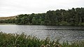 (c) Richard Webb, CC BY-SA 2.0Clubbiedean Reservoir
 (c) michael ely, CC BY-SA 2.0Bonaly Reservoir
 (c) Iain Lees, CC BY-SA 2.0Loganlea Reservoir
 (c) Richard Webb, CC BY-SA 2.0Glencorse Reservoir
 (c) Richard Webb, CC BY-SA 2.0Threipmuir Reservoir
 (c) Mike Beeson, CC BY-SA 2.0Harlaw Reservoir
 (c) Jim Barton, CC BY-SA 2.0North Esk Reservoir
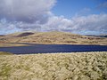 (c) Keith Dickson, CC BY-SA 2.0West Water Reservoir
 (c) Callum Black, CC BY-SA 2.0Crosswood Reservoir
 (c) Richard Webb, CC BY-SA 2.0Baddinsgill Reservoir
 (c) james denham, CC BY-SA 2.0Harperrig Reservoir
Einzelnachweise
- ↑ a b Eintrag im Gazetteer for Scotland
- ↑ a b c d e Pentland Hills, in: F. H. Groome: Ordnance Gazetteer of Scotland: A Survey of Scottish Topography, Statistical, Biographical and Historical. Grange Publishing, Edinburgh, 1885.
- ↑ Eintrag im Gazetteer for Scotland
- ↑ Eintrag im Gazetteer for Scotland
- ↑ Eintrag im Gazetteer for Scotland
- ↑ Eintrag im Gazetteer for Scotland
- ↑ Eintrag im Gazetteer for Scotland
- ↑ Eintrag im Gazetteer for Scotland
- ↑ Eintrag im Gazetteer for Scotland
- ↑ Eintrag im Gazetteer for Scotland
- ↑ Eintrag im Gazetteer for Scotland
- ↑ Eintrag im Gazetteer for Scotland
- ↑ Eintrag im Gazetteer for Scotland
- ↑ Eintrag im Gazetteer for Scotland
- ↑ Eintrag im Gazetteer for Scotland
- ↑ Eintrag im Gazetteer for Scotland
- ↑ Eintrag im Gazetteer for Scotland
- ↑ Eintrag im Gazetteer for Scotland
- ↑ Eintrag im Gazetteer for Scotland
- ↑ Eintrag im Gazetteer for Scotland
- ↑ Eintrag im Gazetteer for Scotland
- ↑ Eintrag im Gazetteer for Scotland
- ↑ Eintrag im Gazetteer for Scotland
- ↑ Eintrag im Gazetteer for Scotland
- ↑ Eintrag im Gazetteer for Scotland
- ↑ Eintrag im Gazetteer for Scotland
- ↑ Eintrag im Gazetteer for Scotland
- ↑ Eintrag im Gazetteer for Scotland
- ↑ Eintrag im Gazetteer for Scotland
- ↑ Eintrag im Gazetteer for Scotland
- ↑ Eintrag im Gazetteer for Scotland
- ↑ Eintrag im Gazetteer for Scotland
- ↑ Eintrag im Gazetteer for Scotland
- ↑ Eintrag im Gazetteer for Scotland
- ↑ Eintrag im Gazetteer for Scotland
- ↑ Eintrag im Gazetteer for Scotland
- ↑ Eintrag im Gazetteer for Scotland
- ↑ Eintrag im Gazetteer for Scotland
- ↑ Eintrag im Gazetteer for Scotland
- ↑ Eintrag im Gazetteer for Scotland
- ↑ Eintrag im Gazetteer for Scotland
- ↑ Eintrag im Gazetteer for Scotland
- ↑ Eintrag im Gazetteer for Scotland
Weblinks
Auf dieser Seite verwendete Medien
(c) Richard Webb, CC BY-SA 2.0
Field, Baddinsgill Track running up the Baddinsgill Burn, seen from the road to the Cauldstane Slap. Byrehope Mount in the background.
(c) Richard Webb, CC BY-SA 2.0
East Cairn Hill. East Cairn Hill from the Cauldstane Slap path. The square is grouse moor rising steeply almost to the top of East Cairn Hill. Looking SE.
(c) Callum Black, CC BY-SA 2.0
Henshaw Hill. This is a view of the rather uninspiring eastern slopes of Henshaw Hill. The surrounding countryside is mainly rough bog and heather.
(c) Callum Black, CC BY-SA 2.0
Grouse Butt on Black Birn. Looking south from a line of rather dilapidated grouse butts towards Harrows Law.
(c) Richard Webb, CC BY-SA 2.0
Torweaving Hill Looking over rough grassland towards the ruin on Torweaving Hill.s
(c) Callum Black, CC BY-SA 2.0
Catstone summit. A newish track has been bulldozed over the top of the hill. Looking northwest with some foul weather in the distance over West Lothian.
(c) Callum Black, CC BY-SA 2.0
Windswept larches. Braid Law from the southeast ridge of Cap Law. It's easy to tell the prevailing wind direction.
(c) Richard Webb, CC BY-SA 2.0
Cap Law Plantation Looking across the Eastside Burn from the slopes of West Kip. The plantation used to be just made up of old trees, but has been replanted.
(c) G Laird, CC BY-SA 2.0
East Kip Viewed from the path up Scald Law. West Kip also prominent behind East Kip.
(c) M J Richardson, CC BY-SA 2.0
Boghall Glen and Woodhouselee Hill The burn runs in a steep valley here.

(c) Richard Webb, CC BY-SA 2.0
Threipmuir Reservoir. A stubble field, had grown barley and Threipmuir reservoir backed by Black Hill, Pentlands.

(c) Richard Webb, CC BY-SA 2.0
Grain Heads. The western side of Grain Heads, falling towards Baddinsgill Reservoir. The suspension bridge 76982 cand be seen on the near arm of the reservoir where the Glenmade Burn was flooded.
(c) Callum Black, CC BY-SA 2.0
South Black Hill Southern top of Scald Law.
(c) Richard Webb, CC BY-SA 2.0
Green Law. Green Law taken from near the col with Spittal Hill.
(c) Eileen Henderson, CC BY-SA 2.0
Track on Mid Hill This well-defined track, which is unmarked on either the OS 1:50,000 or 1:25,000 map, winds almost to the top of Mid Hill on its northern side. This view looks towards Bleak Law. The light-coloured strip on Bleak Law is not a track, but evidence of heather-management.
(c) Richard Webb, CC BY-SA 2.0
West Kip. A very shapely summit, seen from the north. Taken from NT170609
(c) M J Richardson, CC BY-SA 2.0
Dunsyre Hill With spring gorse, and readily visible terraces. There seems to be some dispute about the age and function of the terraces - some say mediaeval, others suggest they may date from the time of the Caledonian tribes, and some say that they are too high to have been useful for cultivation!

(c) michael ely, CC BY-SA 2.0
Bonaly Reservoir. Situated on a great mountain biking track leading into the Pentland Hills from the outskirts of south Edinburgh near Colinton. Note Bonaly is spelt "Bonally" on the 1940s map.
(c) Tom Richardson, CC BY-SA 2.0
Path up Allermuir Hill
(c) Richard Webb, CC BY-SA 2.0
Grain Heads. The name refers to the marshy burns that run off its slopes. Two different farms either side of the fence means two ATV tracks. An update of an older photo taken here 76996.

(c) james denham, CC BY-SA 2.0
Grazing land overlooking Harperrig Reservoir

(c) Richard Webb, CC BY-SA 2.0
Clubbiedean Reservoir Built in 1849, the reservoir has had time to develop a mature, natural looking shoreline.

(c) Richard Webb, CC BY-SA 2.0
Threipmuir Reservoir. The Bavelaw end, a shallow lagoon full of birdlife on a still morning. On the way home I learnt that Threip in place names referred to a dispute. So this was once a debatable land. This end of the reservoir is managed as a nature reserve.
(c) Chris Eilbeck, CC BY-SA 2.0
Cock Rig. Taken from the Bore Stane path.
(c) Callum Black, CC BY-SA 2.0
Faw Mount. Small top at the south end of the ridge from Mount Maw. View to Mendick Hill.
(c) Richard Webb, CC BY-SA 2.0
West Cairn Hill. Approaching the summit from the southeast. One of the gateposts of the Cauldstane Slap pass, this hill is quite a landmark especially from the west of Edinburgh and Livingston.
(c) M J Richardson, CC BY-SA 2.0
Pentland Nursery And the Pentland Hills [Caerketton Hill] beyond.

(c) Callum Black, CC BY-SA 2.0
Crosswood Reservoir. A few fishing boats line the shore of this quiet reservoir on the west side of the Pentlands.
(c) Richard Webb, CC BY-SA 2.0
Bell's Hill As seen across Glencorse Reservoir.
(c) Richard Webb, CC BY-SA 2.0
White Craig and Darlees Rig One of the few distinct hills in the southern part of the Pentland Hills. View from the slopes of Craigengar.

(c) Mike Beeson, CC BY-SA 2.0
Harlaw Reservoir. You can't get much nearer perfection for fly fishing.
(c) Richard Webb, CC BY-SA 2.0
Craigengar. Southernmost of the 500m Pentland summits, a remote sandstone hill surrounded by heavy going. Taken from the descent of Byrehope Mount as it crossed the corner of the square which is dominated by the hill.
(c) Richard Webb, CC BY-SA 2.0
Pentlands from Mauldslie Hill. Looking down from the Southern Upland scarp across Gladhouse Reservoir to the Pentland Hills amongst widespread fog in central Scotland. Meanwhile back on the Moorfoot Hills, the tussocks continue.
(c) Richard Webb, CC BY-SA 2.0
Spittal Hill. Just south of the summit. The hills here are grassy, and used for sheep farming.
(c) Calum McRoberts, CC BY-SA 2.0
Castlelaw Hill From the sparsely wooded slopes of Turnhouse Hill you get a fine view over Glencorse to Castlelaw Hill with the military rifle range also visible.

(c) Richard Webb, CC BY-SA 2.0
Mount Maw One of the higher Pentland summits, situated above Carlops and Baddinsgill Reservoir. The slopes are gentle and this is a fine objective for a short hillwalk. There is a decaying triangulation pillar at the summit. The hills here are grazed by sheep and cattle.
(c) Callum Black, CC BY-SA 2.0
Mealowther from Craigengar. Looking along the fence that links Craigengar with Mealowther.
(c) michael ely, CC BY-SA 2.0
Capelaw Hill Looking from the edge of Bonaly Country Park.
(c) Jim Barton, CC BY-SA 2.0
Summit of Harbour Hill 421 m A rather indeterminate summit, just east of the path. Looking to Capelaw with Allermuir Hill beyond.
(c) G Laird, CC BY-SA 2.0
Carnethy Hill Viewed from the path down Scald Law.
(c) Richard Webb, CC BY-SA 2.0
Turnhouse Hill From the lower end of the east ridge of Carnethy Hill. Turnhouse Hill now has a path over it. It was barely marked grass in the early 1980s.

(c) Keith Dickson, CC BY-SA 2.0
West Water Reservoir West Water Reservoir from Slipperfield Mount
(c) Chris Eilbeck, CC BY-SA 2.0
Hare Hill. Looking across Logan Burn, with Threipmuir Reservoir in the distance.

(c) Eric Gaba, NordNordWest, Uwe Dedering, CC BY-SA 3.0
Positionskarte von Schottland, Vereinigtes Königreich
(c) Richard Webb, CC BY-SA 2.0
Scald Law Scald Law and the narrow path as seen across the Kirk Road and the start of the ascent of Carnethy Hill.
(c) Chris Martin, CC BY-SA 2.0
Darlees Rig, Harrows Law behind Taken from near Cairn Knowe

(c) Richard Webb, CC BY-SA 2.0
Torduff Reservoir. One of the earliest Edinburgh reservoirs, tucked into a steep cleuch behind Torphin Hill.

(c) Richard Webb, CC BY-SA 2.0
Glencorse Reservoir A wet and windy day by Glencorse Reservoir in the Pentland Hills. The wind is funnelled down the glen and was very strong at the point where the glen takes a right-angle turn to the southwest.
(c) Richard Webb, CC BY-SA 2.0
Patie's Hill A Pentland sheepwalk above the North Esk.

(c) Jim Barton, CC BY-SA 2.0
Path down to the N Esk Reservoir