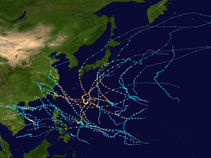
Pazifische Taifunsaison 2005

Nachfolgend finden Sie eine Liste der Taifune, die 2005 im Nordwestpazifik aufgetreten sind.[1]
Aufführen
| Nummer | Name[1] | Entstehung (UTC) | Auflösung (UTC) | Niedrigster (hPa) |
|---|---|---|---|---|
| 200501 | KULAP | 2005-01-15 12:00 | 2005-01-19 06:00 | 985 |
| 200502 | ROKE | 2005-03-15 00:00 | 2005-03-17 12:00 | 980 |
| 200503 | SONCA | 2005-04-23 00:00 | 2005-04-27 12:00 | 935 |
| 200504 | NESAT | 2005-05-31 12:00 | 2005-06-11 00:00 | 930 |
| 200505 | HAITANG | 2005-07-13 00:00 | 2005-07-20 06:00 | 920 |
| 200506 | NALGAE | 2005-07-20 12:00 | 2005-07-24 12:00 | 990 |
| 200507 | BANYAN | 2005-07-21 18:00 | 2005-07-28 00:00 | 975 |
| 200508 | WASHI | 2005-07-29 12:00 | 2005-07-31 18:00 | 985 |
| 200509 | MATSA | 2005-07-31 12:00 | 2005-08-07 12:00 | 950 |
| 200510 | SANVU | 2005-08-11 06:00 | 2005-08-13 18:00 | 985 |
| 200511 | MAWAR | 2005-08-19 18:00 | 2005-08-28 00:00 | 930 |
| 200512 | GUCHOL | 2005-08-21 06:00 | 2005-08-25 12:00 | 980 |
| 200513 | TALIM | 2005-08-27 00:00 | 2005-09-02 06:00 | 925 |
| 200514 | NABI | 2005-08-29 12:00 | 2005-09-08 06:00 | 925 |
| 200515 | KHANUN | 2005-09-07 00:00 | 2005-09-13 00:00 | 945 |
| 200516 | VICENTE | 2005-09-16 12:00 | 2005-09-18 18:00 | 985 |
| 200517 | SAOLA | 2005-09-20 18:00 | 2005-09-26 12:00 | 950 |
| 200518 | DAMREY | 2005-09-21 00:00 | 2005-09-27 18:00 | 955 |
| 200519 | LONGWANG | 2005-09-26 00:00 | 2005-10-03 00:00 | 930 |
| 200520 | KIROGI | 2005-10-10 06:00 | 2005-10-19 06:00 | 930 |
| 200521 | KAI-TAK | 2005-10-29 00:00 | 2005-11-02 06:00 | 950 |
| 200522 | TEMBIN | 2005-11-10 00:00 | 2005-11-10 12:00 | 1002 |
| 200523 | BOLAVEN | 2005-11-16 06:00 | 2005-11-20 00:00 | 985 |
Saisonüberblick
Einzelnachweise
- ↑ a b Digital Typhoon: Record of Typhoon in 2005 Season. Abgerufen am 14. August 2021.
Auf dieser Seite verwendete Medien
2005 Pacific typhoon season summary map.png
This map shows the tracks of all tropical cyclones in the 2005 Pacific typhoon season. The points show the location of each storm at 6-hour intervals. The colour represents the storm's maximum sustained wind speeds as classified in the Saffir-Simpson Hurricane Scale (see below), and the shape of the data points represent the type of the storm.
This map shows the tracks of all tropical cyclones in the 2005 Pacific typhoon season. The points show the location of each storm at 6-hour intervals. The colour represents the storm's maximum sustained wind speeds as classified in the Saffir-Simpson Hurricane Scale (see below), and the shape of the data points represent the type of the storm.
Muifa Jul 30 2011 1909Z.jpg
The Operational Linescan System (OLS) Satellite captured this Infrared Satellite Image of Muifa at peak intensity with an unofficial central pressure of 918hpa as sated by the JTWC late on July 30 2011 over the the Philippine Sea.
The Operational Linescan System (OLS) Satellite captured this Infrared Satellite Image of Muifa at peak intensity with an unofficial central pressure of 918hpa as sated by the JTWC late on July 30 2011 over the the Philippine Sea.


