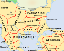
Paristrion
Das byzantinische Thema Paristrion (Paradunavon) war ein militärisch-administrativer Grenzdistrikt, der um 1001 in der geographischen Region Moesia (Donaubulgarien) gebildet worden war. Hauptort war Theodoroupolis (in der Antike Durostorum, heute Silistra). Weitere bedeutende Städte waren Odessos, Nikopolis und Tarnowo. Der Name des Distrikts leitet sich aus dem Griechischen ab und bedeutet Am Ister gelegen.
Das Thema entstand nach der erfolgreichen Teilunterwerfung des Ersten Bulgarischen Reiches durch das Byzantinische Reich um 971, als die einst als Provinz Moesia secunda bekannte Region erneut in das byzantinische Verwaltungssystem integriert wurde. Später grenzte Paristrion im Westen an das 1018 geschaffene Thema Bulgarien und im Süden an die Themata Thrakien und Makedonien. Um 1072/1074 war die Region das Zentrum einer Rebellion der Petschenegen unter dem byzantinischen Überläufer Nestor. Nach der Wiederherstellung des Bulgarischen Reiches 1187 bis zum Auftreten der osmanischen Türken wechselte die Herrschaft über das Gebiet häufig zwischen Bulgaren und den Reitervölkern aus dem Osten.
Quellen
- Konstantin Porphyrogennetos: De thematibus, Lib. II.
Literatur
- John V. A. Fine: The Early Medieval Balkans. A Critical Survey from the Sixth to the Late Twelfth Century. University of Michigan Press, Ann Arbor MI 1991, ISBN 0-472-08149-7, S. 79.
- Warren Treadgold: A History of the Byzantine State and Society. Stanford University Press, Stanford CA 1997, ISBN 0-8047-2421-0, S. 421, 478, et passim.
Weblinks
- Veröffentlichungen zu Paristrion im Opac der Regesta Imperii
Auf dieser Seite verwendete Medien
Autor/Urheber: NerdyNSK, Lizenz: CC BY-SA 4.0
A map showing the Byzantine themata (administrative units) of the Byzantine Empire in 1045 CE, focusing on central Balkans around the region of Macedonia. The Macedonian thema is in what today is part of present-day Bulgaria, while the Bulgarian thema includes what today is the Republic of North Macedonia. Note that the thematic boundaries in this map, especially those of Strymon and Macedonia, are very inaccurate. Macedonia was actually located further south, up to the Aegean coast of western Thrace

