Palmerston (Northern Territory)
| Palmerston | |||||||
|---|---|---|---|---|---|---|---|
 | |||||||
| |||||||
| |||||||
| |||||||
| |||||||
Palmerston ist eine Stadt im australischen Northern Territory und liegt an der Nordküste etwa 20 km entfernt von der Territoriumshauptstadt Darwin.
Die Stadt wurde 1981 gegründet, nachdem Siedlungsland im Stadtgebiet von Darwin knapp wurde. Der Name Palmerston war der ursprüngliche Name von Darwin vor der Umbenennung 1911. Die Stadt hat knapp 37.000 Einwohner[1] und hat damit Alice Springs als zweitgrößte Stadt des Northern Territory überholt.
Stadtgliederung

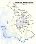
Palmerston gliedert sich in insgesamt 18 suburbs (Stadtbezirke), die von der Regierung des Northern Territory festgelegt werden.
Die ursprünglichen vier Stadtbezirke, die in den frühen 1980er Jahren angelegt wurden, sind Gray, Driver, Moulden und Woodroffe. Dies sind auch die bevölkerungsstärksten Stadtbezirke, gefolgt von Bakewell und Durack.[2] Diese sechs sowie Bellamack, Farrar, Gunn, Palmerston City, Rosebery und Yarrawonga bilden die Innenstadt. Yarrawonga im Nordosten ist vornehmlich Industriegebiet.
Dazu kommen die Außenbezirke Archer, Johnston, Marlow Lagoon, Mitchell, Pinelands und Zuccoli. Zuletzt wurden 2007 die Stadtbezirke Johnston und Zuccoli definiert, die bislang kaum besiedelt sind. Der Stadtbezirk Archer weist keine Wohnbevölkerung auf.
Weblinks
Einzelnachweise
- ↑ a b Palmerston. 2021 Census Quickstat. Australian Bureau of Statistics, 28. Juni 2022, abgerufen am 24. Februar 2023 (englisch).
- ↑ Archivierte Kopie (Memento des vom 15. August 2009 im Internet Archive) Info: Der Archivlink wurde automatisch eingesetzt und noch nicht geprüft. Bitte prüfe Original- und Archivlink gemäß Anleitung und entferne dann diesen Hinweis. Community Profile
Auf dieser Seite verwendete Medien
Flag of Australia, when congruence with this colour chart is required (i.e. when a "less bright" version is needed).
See Flag of Australia.svg for main file information.The flag of the Northern Territory (adopted on July 1, 1978 on the first day of self-government) was designed by the Australian artist Robert Ingpen, of Drysdale Victoria, after consultation with members of the community at the invitation of the Northern Territory government. The flag incorporates the three official territorial colours of black, white and ochre and is divided into two panels, black at the hoist side taking up one third the length of the flag, with the remaining two-thirds in ochre. The black panel displays the five white stars that form the constellation of the Southern Cross, using the Victorian configuration with stars having between five and eight points. The flag also features the official Northern Territory floral emblem on the ochre panel, a stylisation of the Sturt's Desert Rose, which uses seven petals encircling a seven-pointed black star of the federation in the centre. The seven petals symbolise the six Australian states plus the Northern Territory. The Northern Territory Flag was the first official flag that did not contain the Union Jack.
Autor/Urheber: Maximilian Dörrbecker (Chumwa), Lizenz: CC BY-SA 2.0
Karte der Suburbs von Palmerston (Northern Territory)
Autor/Urheber: NordNordWest, Lizenz: CC BY-SA 3.0 de
Positionskarte des Northern Territory, Australien


