Paita
| Paita | ||||
|---|---|---|---|---|
| ||||
| Koordinaten | 5° 5′ 30″ S, 81° 6′ 1″ W | |||
| Basisdaten | ||||
| Staat | Peru | |||
| Region | Piura | |||
| Provinz | Paita | |||
| Stadtgründung | 30. März 1532 | |||
| Einwohner | 81.163 (2017) | |||
| Stadtinsignien | ||||
 |  | |||
| Detaildaten | ||||
| Höhe | 3 m | |||
| Gewässer | Pazifischer Ozean | |||
| Stadtvorsitz | Teodoro Alvarado Alayo (2019–2022) | |||
| Website | ||||
_is_anchored_off_Paita%2c_Peru_during_a_Continuing_Promis.jpg) | ||||
.jpg) | ||||
Paita (früher: San Francisco de la Buena Esperanza) ist eine Hafenstadt am Pazifischen Ozean im Nordwesten von Peru. Die Stadt liegt im gleichnamigen Distrikt Paita und in der gleichnamigen Provinz Paita der Region Piura. Paita liegt 640 km nordwestlich der Landeshauptstadt Lima und 75 km westnordwestlich der Regionshauptstadt Piura.
Lage
Die Hafenstadt Paita liegt auf einer Halbinsel an der Bucht von Paita, südlich der Mündung des Río Chira. Sie ist durch die Landzunge Punta Paita mit dem Höhenzug Silla de Paita vor dem Südwind geschützt.
90 km südlich von Paita liegt das regionale Zentrum Piura und 160 km im Süden Chiclayo, das Handelszentrum der Region Lambayeque.
Bevölkerung
Beim Zensus 2017 betrug die Einwohnerzahl von Paita 81.163, 10 Jahre zuvor lag diese bei 66.548.[1]
Geschichte

Von 1578 bis 1588 war Paita die spanische Hauptstadt der peruanischen Nordwestküste. Wegen andauernder Überfälle englischer Piraten und Korsaren wurde die Hauptstadt jedoch in das heutige Piura verlegt. 1741 brandtschatze George Anson Paita.
Die Hafenstadt ist vielen Peruanern vor allem als Wohnsitz von Manuela Sáenz, der Geliebten des Befreiungshelden Simón Bolívar, bekannt.
Verkehr
1875 ging ein erster Abschnitt der Bahnstrecke Paita–Piura in Betrieb. Im Salpeterkrieg (1879–1883) wurde sie zerstört und 1884 wieder in Betrieb genommen. Die Bahn wurde 1959 stillgelegt.[2]
Vom 30. August 1891 bis in die späten 1920er-Jahre gab es in Paita eine Straßenbahnlinie.
Hafen
Der vor allem für die Containerschifffahrt bedeutende Seehafen von Paita ist – gemessen am Güterumschlag – Perus zweitgrößter Hafen, nach dem von Callao (Stand: 2018).[3]
Paita ist einer der besten Naturhäfen an der peruanischen Küste, von hier gibt es regelmäßige Schiffsverbindungen nach Valparaíso und Panama.
Feste
Am 24. September jeden Jahres wird eine Woche lang die Fiesta de Nuestra Señora de las Mercedes gefeiert, u. a. mit Wallfahrten zu Ehren der Jungfrau Maria.
Einzelnachweise
- ↑ Peru: Region Piura – Provinzen & Orte. www.citypopulation.de, abgerufen am 23. Dezember 2019.
- ↑ Robert D. Whetham: Railways of Peru. Volume 1: The Northern Lines. Trackside Publications, Skipton 2007. Ohne ISBN, S. 17–19.
- ↑ Comisión Económica para América Latina y el Caribe (CEPAL): Datos estadísticos del Informe de la actividad portuaria de América Latina y el Caribe 2018, abgerufen am 7. September 2020.
Weblinks
Auf dieser Seite verwendete Medien
Autor/Urheber: Galeria del Ministerio de Defensa del Perú, Lizenz: CC BY 2.0
MINISTRO VALAKIVI PARTICIPÓ EN EL SIMULACRO DE RESPUESTA ANTE LA LLEGADA DEL FENÓMENO EL NIÑO EN LA REGIÓN PIURA
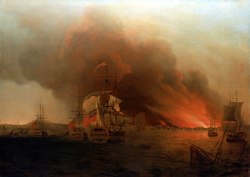
The Burning of Payta, November 1741
In 1740, while Britain was at war with Spain, Commodore George Anson led a squadron of eight ships on a mission to disrupt or capture Spain's Pacific possessions. Returning to England in 1744 by way of China he thus completed a circumnavigation of the world. During this trip, on 13 November 1741 Commodore Anson made a surprise attack on the Spanish town of Payta, on the coast of what is now Peru. Although the attack was successful, the Governor escaped and with him the chance of a ransom was lost. Anson threatened to burn down the town if he did not give himself up, but this was refused, and Payta was consequently set on fire on 15 November. This resulted in plunder of £32,000 and six vessels sunk in the bay.
The painting by Samuel Scott was specially painted for Lord Anson after his return from his voyage and is based on an eye witness drawing by the ‘Centurion’s first lieutenant, Piercy Brett. Just to left of centre the ‘Centurion’ is shown at anchor together with the ‘Tryal’ one of the other five prizes to her left, and surrounded by wrecks of sunken vessels. To the right two more of the prizes are running down from Payta which is burning fiercely. The fifth prize is at anchor and a sunken vessel is in the extreme right foreground. The painting was originally owned by Anson, and probably commissioned by him.
PAITA, Peru (April 30, 2011) The Military Sealift Command hospital ship USNS Comfort (T-AH 20) is anchored off Paita, Peru during a Continuing Promise 2011 port visit. Continuing Promise is a five-month humanitarian assistance mission to the Caribbean, Central and South America. (U.S. Navy photo by Mass Communication Specialist 2nd Class Eric C. Tretter/Released)
Autor/Urheber: Made and uploaded by Huhsunqu., Lizenz: CC BY-SA 2.5
Flag of Paita.

Autor/Urheber: User:Spischot, Lizenz: CC BY-SA 3.0
Blank political map of Peru