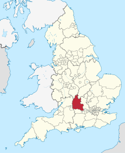
Oxfordshire
| Grafschaft Oxfordshire | |||
|---|---|---|---|
| |||
 | |||
| Staat | Vereinigtes Königreich | ||
| Landesteil | England | ||
| Region | South East England | ||
| Status | Zeremonielle und Verwaltungsgrafschaft | ||
| Ersterwähnung | 10. Jahrhundert | ||
| Zeremonielle Grafschaft | |||
| Verwaltungsgrafschaft | |||
| Verwaltungsbehörde | Oxfordshire County Council | ||
| Verwaltungssitz | Oxford | ||
| ISO-3166-2 | GB-OXF | ||
| Fläche | 2.605 km² | ||
| Einwohner | 687.524 | ||
| Stand | 30. Juni 2018[1] | ||
| ONS-Code | 38 | ||
| GSS-Code | E10000025 | ||
| NUTS-Code | UKJ14 | ||
Distrikte / Unitary Authorities | |||
Oxfordshire [] (abgekürzt Oxon, aus dem lateinischen Oxonia) ist eine Grafschaft im mittleren Süden Englands.
Geographie
Etwa 660.000 Menschen leben in dem 2.610 km² großen Gebiet der Grafschaft. Sie wird noch in fünf Bezirke unterteilt: Oxford, Cherwell, Vale of White Horse (nach dem Uffington White Horse), West Oxfordshire und South Oxfordshire.
Das Vale of the White Horse und Teile von South Oxfordshire südlich der Themse waren früher Teile der Grafschaft Berkshire und kamen 1974 nach einer Gebietsreform zu der heutigen Grafschaft. Dagegen war das Gebiet von Caversham bei Reading schon immer Teil Oxfordshires.
Verwaltungssitz und größte Stadt der Grafschaft ist Oxford. Weitere größere Städte sind Banbury, Bicester und Chipping Norton im Norden Oxfords, Faringdon und Witney im Westen, Chinnor, Watlington und Thame im Osten und Abingdon, Didcot, Grove, Henley, Wallingford und Wantage im Süden.
Geschichte
Historisch betrachtet war das Land um Oxford bereits früh besiedelt. Das Ackerland ist sehr fruchtbar und besitzt hochwertige Böden. Der Name Oxford kommt aus dem Altenglischen Oxenaforda. Die Gegend wurde zunächst durch die Römer völlig ignoriert. Allein die Siedlung Wantage, in der der spätere König Alfred der Große von Wessex geboren wurde, war von geringer Bedeutung. Die Universität von Oxford wurde 1096 gegründet. Die Gegend war Teil des Cotswolds-Wollhandels ab dem 13. Jahrhundert. Mit dem Bau der Eisenbahn, der Great Western Railway, wurde Didcot 1839 angeschlossen. Die Morris Motor Company wurde 1912 in Oxford gegründet, Morris Garages (MG) in Abingdon im Jahr 1929.
Wirtschaft
Insbesondere der Tourismus ist einer der größeren Wirtschaftszweige in der Grafschaft. Mehrere Motorsportfabriken und -unternehmen sind in der Gegend angesiedelt. Daneben bestehen zahlreiche Verlage wie die Oxford University Press und mehrere Unternehmen der Biotechnologiebranche.
Städte und Orte in Oxfordshire
- Abingdon, Adderbury, Adwell, Appleton, Ascot d’Oley, Asthall, Aston
- Bampton, Banbury, Barton, Beckley, Bicester, Binsey, Bix, Bletchingdon, Blewbury, Bloxham, Brightwell Baldwin, Broughton, Bucknell, Burcot, Burford
- Caldecott, Carterton, Charlbury, Charlton-on-Otmoor, Chesterton, Chilton, Chinnor, Chipping Norton, Chiselhampton, Cholsey, Christmas Common, Coleshill, Cropredy, Cuddesdon, Culham, Cumnor
- Deddington, Denchworth, Didcot, Dorchester-on-Thames
- East Hagbourne, East Hendred, Enstone, Ewelme, Eynsham
- Faringdon, Fernham, Fringford
- Garsington, Goring-on-Thames, Great Bourton, Great Haseley, Great Milton, Great Rollright, Great Tew, Grove
- Harpsden, Harwell, Henley-on-Thames, Hook Norton, Horspath
- Ipsden, Islip
- Kelmscott, Kennington, Kidlington, Kingham, Kirtlington
- Leafield, Lewknor, Little Haseley, Little Milton, Little Tew, Little Wittenham, Lower Heyford
- Mapledurham, Marston, Middleton Stoney, Moreton, Moulsford
- Nettlebed, North Stoke, Nuneham Courtenay
- Oddington, Oxford
- Pishill
- Radley, Rousham
- Sanford-on-Thames, Shellingford, Shenington, Shillingford, Shiplake, Shipton-under-Wychwood, Shirburn, Shrivenham, Shutford, Somerton, Sonning Eye, Spelsbury, Stadhampton, Stanford in the Vale, Stanton Harcourt, Stanton St. John, Steeple Aston, Stoke Row, Stonor, Stratton Audley, Sutton Courtenay, Swalcliffe, Swinbrook, Sydenham
- Tackley, Thame
- Uffington, Upper Heyford
- Wallingford, Wantage, Warborough, Wardington, Watchfield, Waterstock, Watlington, Wheatley, Winderton, Witney, Woodstock, Wootton, Wroxton, Wytham
Politik
Stadtrat (Grafschaftsrat)
Sehenswürdigkeiten
- Abingdon Abbey
- Abingdon Lock
- Ardington House
- Ashdown House
- Asthall Manor
- Beckett House
- Blenheim Palace, UNESCO-Weltkulturerbe
- Buscot Park
- Cogges Manor
- Coleshill House
- Cuddesdon Brook
- Culham Old Bridge
- Deddington Castle
- Didcot Railway Centre, Museum der Great Western Railway
- Dragon Hill, Hügel in Uffington
- Eynsham Lock
- Faringdon Castle
- Faringdon Folly Tower
- Garsington Manor
- Goring Lock
- Grove House in Kidlington
- Greys Court
- Hook Norton Brewery
- Kelmscott Brook
- Kelmscott Manor, Landhaus von William Morris
- Little Wittenham Bridge
- Mapledurham House
- Mapledurham Lock
- Mapledurham Watermill
- Nuffield Place
- Oxford, UNESCO-Weltkulturerbe
- Radley College
- Rousham House und Gärten
- Shiplake Lock
- Shirburn Castle
- St. Mary’s Church (Swinbrook)
- Themse
- Uffington Castle
- Wayland’s Smithy
- White Horse Hill
Kulinarische Spezialitäten
- Banbury Cake, Mürbeteig mit Johannisbeeren gefüllt
- Lardy Cake, ähnlich einer Schnecke (Gebäck)
- Marmelade von der Marke Frank Cooper’s
- New College Pudding
Sonstiges
- Abingdon ist für den englischen Keramiktyp Abingdon Ware bekannt.
Weblinks
- Oxfordshire County Council – Seite der Verwaltung und Grafschaft Oxfordshire (englisch)
- Literatur von und über Oxfordshire im Katalog der Deutschen Nationalbibliothek
Einzelnachweise
- ↑ Mid 2018 Estimates of the population for the UK, England and Wales, Scotland and Northern Ireland
- ↑ Local elections 2024: full mayoral and council results for England. In: The Guardian. 4. Mai 2024, abgerufen am 20. Dezember 2024.
Koordinaten: 51° 46′ N, 1° 16′ W
Auf dieser Seite verwendete Medien
Autor/Urheber: Vexilo, Lizenz: CC BY-SA 4.0
The registered flag of Oxfordshire.
Autor/Urheber: TUBS
Lage der ländlichen Grafschaft XY (siehe Dateiname) in England.


