Osama (Mondkrater)
| Osama | ||
|---|---|---|
 | ||
| Osama | ||
| Position | 18,59° N, 5,26° O | |
| Durchmesser | 420 m | |
| Kartenblatt | 41 (PDF) | |
| Benannt nach | arabischer Männername | |
| Benannt seit | 1976 | |
| Sofern nicht anders angegeben, stammen die Angaben aus dem Eintrag in der IAU/USGS-Datenbank | ||
Osama ist ein kleiner Einschlagkrater auf der Mondvorderseite im Lacus Felicitatis nördlich des Kraters Yangel.
Die namentliche Bezeichnung geht auf eine ursprünglich inoffizielle Bezeichnung auf Blatt 41C3/S1[1] der Topophotomap-Kartenserie der NASA zurück, die von der IAU 1979 übernommen wurde.[2]
Weblinks
Einzelnachweise
- ↑ Topophotomap 41C3/S1
- ↑ Exzerpt der Proceedings der 16. Generalversammlung der IAU (Grenoble 1976). In: Transactions of the IAU Bd. XVIB, Hrsg. von D. Riedel, 1977
Auf dieser Seite verwendete Medien
Small (400 m) crater Osama on the Moon, in Lacus Felicitatis, near crater Ina (a map). Centered at 18.605°N, 5.271°E (according to JMARS). Photo by Lunar Reconnaissance Orbiter, made with Narrow Angle Camera 27 November 2009 from altitude 45 km. Sun elevation is 32.3°. Width of the photo is 670 m, north is up.
NASA lunar chart of equatorial region (latitudes 45S to 45N) 1 : 10.000.000 (LPC-1).
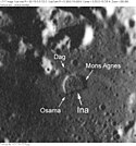
Moon craters Ina, Dag, Osama and Mons Agnes. Detail from Apollo 17 metric image AS17-M-1518, remapped to a north-up aerial view by LTVT.


