Ortungsfunkstelle
Eine Ortungsfunkstelle (OrtFuSt, englisch radiodetermination station) ist gemäß Definition der VO Funk eine Funkstelle des Ortungsfunkdienstes zum Zwecke der Funkortung.[1] Diese benutzt den Empfang von Funkwellen zur Bestimmung des Ortes eines Gegenstandes unter der Voraussetzung, dass dieser Funkwellen reflektiert oder aussendet.
Unter diesem Begriff ist das Radargerät allgemein und im Besonderen bis hin zu Zielbeleuchter, Funkmeß-Visier, Radar-Höhenfinder, Raketenleitradar und Feuerleitradar in Waffensystemen einzuordnen, aber auch Navigationsfunkstellen, Funkfeuer etc. an Land, in Satelliten, auf Schiffen oder Flugkörpern.
Gemäß VO Funk zählen u. a. folgende Arten von Funkstellen zu dieser Kategorie:
Ortungsfunkstelle
- Mobile Navigationsfunkstelle
- Ortsfeste Navigationsfunkstelle
- Mobile nichtnavigatorische Ortungsfunkstelle
- Ortsfeste nichtnavigatorische Ortungsfunkstelle
- Peilfunkstelle
Auswahl an Ortungsfunkstellen:

Parabolantenne einer OrtFuSt

Air Traffic Control
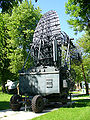
Mobiler Radar-Höhenfinder
Mobile OrtFuSt, Typ AN/TPS-77
Luftraumüberwachung
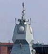
Active Phased Array Radar (APAR) der deutschen Fregatte Hamburg (F 220)

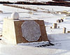
OrtFuSt „Lichtenstein SN-2“ der ME Bf 110G
Waffenleitung

Auf Seeplattform
 (c) Bundesarchiv, Bild 101I-356-1845-08 / Müller / CC-BY-SA 3.0

Siehe auch
Einzelnachweise
- ↑ Radio Regulations, Ausgabe 2012, Art. 1.86
Auf dieser Seite verwendete Medien

Cropped version focusing on the manned Mark 68 gun fire control system weapons director with parabolic dish for AN/SPG-53F on top; ITU-classificatio: Radiolocation land station in the radiolocation service.
Original description:A partial starboard view of the guided missile destroyer USS Coontz (DDG-40), showing the ship's superstructure and masts.

(c) Nick-D at the English Wikipedia, CC BY-SA 3.0
AN/TPS-77 der RAAF; ITU-Klassifizierung: ortsfeste nichtnavigatorische Ortungsfunkstelle im nichtnavigatorischen Ortungsfunkdienst.
_aboard.jpg)
Pearl Harbor, Hawaii (Jan. 9, 2006) - The heavy lift vessel MV Blue Marlin enters Pearl Harbor, Hawaii, with the Sea-based X-band Radar (SBX) aboard after completing a 15,000-mile journey from Corpus Christi, Texas. SBX is a combination of the world's largest phased array X-band radar carried aboard a mobile, ocean-going semi-submersible oil platform. It will provide the nation with highly advanced ballistic missile detection and will be able to discriminate a hostile warhead from decoys and countermeasures. SBX will undergo minor modifications, post-transit maintenance and routine inspections in Pearl Harbor before completing its voyage to its homeport of Adak, Alaska in the Aleutian Islands.

Autor/Urheber: USN, Lizenz: CC BY-SA 3.0
The Thales Nederland Active Phased Array Radar (APAR), mounted on the German Sachsen class frigate Hamburg (F 220); ITU-classificatio: Radiolocation land station in the radiolocation service.

Czechoslovak rrecision approach radar Tesla OPRL-4 (Aircraft muzeum Kbely http://www.militarymuseum.cz)

A Bf 110G-4 Night fighter at the RAF Museum in London. The antennas on the nose are of a FuG 220 Lichtenstein SN-2 radar set (ITU-classificatio: Radiolocation land station in the radiolocation service). Clearly visible are the openings for two 20mm cannons in the lower nose and two 30 mm cannons in the upper nose.

(c) Bundesarchiv, Bild 101I-356-1845-08 / Müller / CC-BY-SA 3.0

Mobiler Radar Höhenfinder PRW-17 (UDSSR), Index GRAU 1PL141; eine zwei-dimensionale mobile nichtnavigatorische Ortungsfunbkstelle im nichtnavigatorischen Ortungsfunkdienst.

This RADAR is the ARPA Long-Range Tracking And Instrumentation Radar (ALTAIR) located in the Kwajalein atoll on the island of Roi-Namur in the Ronald Reagan Ballistic Missile Defense Test Site. It was initially developed and built between 1968 and 1970.
ITU-classificatio: Radiolocation land station in the radiolocation service. For full specifications see: