Onotoa
| Onotoa | ||
|---|---|---|
 | ||
| Gewässer | Pazifischer Ozean | |
| Archipel | Gilbertinseln | |
| Geographische Lage | 1° 51′ S, 175° 33′ O | |
| Anzahl der Inseln | 6 | |
| Hauptinsel | Buariki | |
| Landfläche | 15,62 km² | |
| Lagunenfläche | 75,38 km² | |
| Höchste Erhebung | 3 m | |
| Einwohner | 1417 (2020[1]) | |
 | ||
 | ||
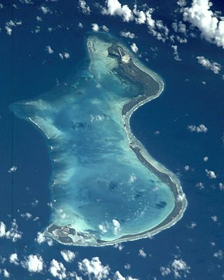
Onotoa ist ein Atoll im pazifischen Archipel der Gilbertinseln und gehört zum Staat Kiribati. Es liegt ca. 70 km nordwestlich von Tamana, der kleinsten Insel des Archipels.
Geographie
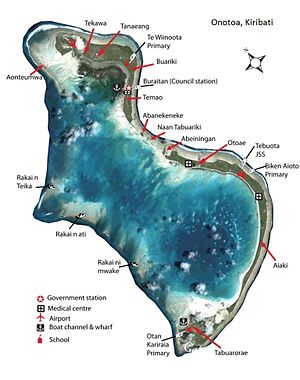
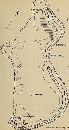
Das Atoll hat seine aneinandergereihten Inseln auf der Ostseite, während die Lagune auf der Westseite durch Korallenriffe begrenzt wird. Die größten Inseln sind Tanyah im Nordosten und Otoae (Otowae, Otoeie) im Südosten, mit vier beziehungsweise zwei Dörfern. Zwischen diesen beiden liegen drei kleine, unbewohnte Inseln: Abanekeneke, Naan Tabuariki und Abeiningan. Über diese Inseln verläuft auf einem künstlichen Damm die Straße, die die beiden größten Inseln verbindet. Die dritte bewohnte Insel, Tabuarorae mit dem gleichnamigen Dorf, bildet die Südspitze des Atolls. Im südwestlichen Riffsaum sind die drei Riffe Rakai n Teika, Rakai n ati und Rakai ni mwake namentlich ausgezeichnet.
Bevölkerung
Bevölkerungsstatistik
| Zensus | 1978[2] | 2005[3] | 2010[4] | 2015[5] | 2020[6] |
|---|---|---|---|---|---|
| Tekawa | 164 | 162 | 145 | 133 | |
| Tanaeang | 249 | 186 | 189 | 174 | |
| Buariki | 213 | 299 | 183 | 209 | |
| Temao | 348 | 226 | 279 | 219 | |
| Otowae | 238 | 210 | 164 | 237 | |
| Aiaki | 186 | 202 | 227 | 222 | |
| Tabuarorae | 246 | 234 | 206 | 223 | |
| Gesamt | 2034 | 1644 | 1519 | 1393 | 1417 |
Bevölkerungsentwicklung
| Zensus | 1947 | 1963 | 1968 | 1973 | 1978 | 1985 | 1990 | 1995 | 2000 | 2005 | 2010 | 2015 | 2020 |
|---|---|---|---|---|---|---|---|---|---|---|---|---|---|
| Gesamt | 1491 | 1993 | 1960 | 1997 | 2034 | 1927 | 2100 | 1918 | 1668 | 1644 | 1519 | 1393 | 1417 |
Neuzeit und Infrastruktur
Die lokalen Belange werden durch einen Inselrat (Onotoa Island Council) geregelt. Onotoa entsendet zwei Parlamentsmitglieder in das Parlament Maneaba ni Maungatabu in South Tarawa, für das 10. Parlament 2011–2015 wurden Taaneti Mamau und Kouraiti Beniato gewählt.[7]
Onotoa verfügt über drei Grundschulen und fünf medizinische Versorgungsstellen. Die Bevölkerung, „I-Onotoa“, lebt von Subsistenzwirtschaft; Haupteinnahmequelle ist die Kopra-Produktion, die nach Angaben des kiribatischen statistischen Amtes für das Jahr 2010 auf insgesamt 70 Tonnen gefallen ist. Die Gewässer vor Onotoa sind von illegalem kommerziellen Fischfang betroffen.
Das Atoll ist mit dem Flugzeug über den an der Nordspitze liegenden Flugplatz Onotoa zu erreichen, der von der Air Kiribati angeflogen wird.
Literatur
- Onotoa (= Republic of Kiribati Island Report Series. Nr. 16). Republic of Kiribati – Office of Te Beretitenti, 2012 (englisch, web.archive.org [PDF; 599 kB]).
Weblinks
- Links zu amtlichen Berichten mit Statistiken und Karten ( vom 16. Januar 2014 im Internet Archive)
- Japanische Karte aus dem Zweiten Weltkrieg mit Tanyah I(sland) und Otoeie I.
Einzelnachweise
- ↑ a b Aritita Tekaieti (Hrsg.): 2020 Population and Housing General Report and Results. Republic of Kiribati – National Statistics Office, Ministry of Finance, Juli 2021, Table G-1: History Table for Kiribati Population by island for Census year 1947 to 2020, S. 17 (englisch, Downloadlink [PDF; 48,2 MB; abgerufen am 8. März 2023]).
- ↑ Report of the 1978 Census of population and housing. Republic of Kiribati 1980, Volume 1, S. 4.
- ↑ Aritita Tekaieti (Hrsg.): 2005 Census of Population – Volume 1: Basic information and tables (Revised version). Republic of Kiribati – National Statistics Office, Ministry of Finance, 17. Januar 2007, Table 3: Population by island, sex, village and broad age group – 2005, S. 20–31, hier: S. 29 f. (englisch, Downloadlink [PDF; 1,1 MB; abgerufen am 8. März 2023]).
- ↑ Aritita Tekaieti, Tekena Tiroa (Hrsg.): Report on the Kiribati 2010 Census of Population and Housing – Vol 1: Basic Information and Tables. Republic of Kiribati – National Statistics Office, Ministry of Finance and Economic Planning, August 2012, Table 3: Population by village, sex and age group – 2010, S. 34–50, hier: S. 48 (englisch, mfed.gov.ki [PDF; 6,7 MB; abgerufen am 8. März 2023]).
- ↑ Orebwa Morate (Hrsg.): 2015 Population and Housing Census – Volume 1: Management Report and Basic Tables. Republic of Kiribati – National Statistics Office, Ministry of Finance, 1. September 2016, Table 3: Population by Village, Sex, And Age Group: 2015, S. 35–51, hier: S. 48 f. (englisch, mfed.gov.ki [PDF; 3,0 MB; abgerufen am 8. März 2023]).
- ↑ Kiribati – Population and Housing Census 2020. Value 1701–1707. In: microdata.pacificdata.org. Pazifische Gemeinschaft, 25. Juni 2024, abgerufen am 7. September 2024 (englisch).
- ↑ Mitglieder des 10. Parlaments 2011–2015 ( vom 27. März 2012 im Internet Archive). Abgerufen am 15. Januar 2014 (englisch).
Auf dieser Seite verwendete Medien
Autor/Urheber: NordNordWest, Lizenz: CC BY-SA 3.0 de
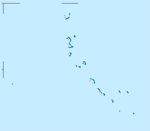
Positionskarte der Gilbert-Inseln, Kiribati
NASA-Astronautenbild von Onotoa, Gilbertinseln, Kiribati
Autor/Urheber: Internet Archive Book Images, Lizenz: No restrictions
Title: Atoll research bulletin
Identifier: atollresearchbu485819smit (find matches)
Year: 1951 (1950s)
Authors: Smithsonian Institution. Press; National Research Council (U. S. ). Pacific Science Board; Smithsonian Institution; National Museum of Natural History (U. S. ); United States. Bureau of Sport Fisheries and Wildlife
Subjects: Coral reefs and islands; Marine biology; Marine sciences
Publisher: Washington, D. C. : (Smithsonian Press)
Contributing Library: Smithsonian Libraries
Digitizing Sponsor: Biodiversity Heritage Library
View Book Page: Book Viewer
About This Book: Catalog Entry
View All Images: All Images From Book
Click here to view book online to see this illustration in context in a browseable online version of this book.
Text Appearing Before Image:
../^TRANSECT A.
Text Appearing After Image:
ONOTOA, GILBERT Turtle grass M Mangrove I Fa t h 0 m li ne lO'TaThom line 2 MILES Adopted from mop by P. E . Cloud.
Note About Images
Autor/Urheber: Government of USA, Government of Kiribati, Lizenz: CC BY-SA 3.0
Astronaut photo of Onotoa, Kiribati with villages and main landmarks
