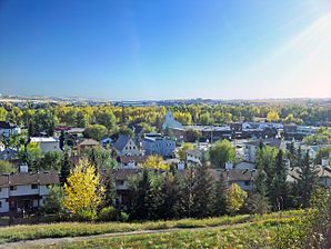
Okotoks
| Okotoks | ||
|---|---|---|
 | ||
| Motto: Historic Past, Sustainable Future | ||
| Lage in Alberta | ||
| Staat: | ||
| Provinz: | Alberta | |
| Municipal District: | Foothills County | |
| Koordinaten: | 50° 44′ N, 113° 58′ W | |
| Höhe: | 1053 m | |
| Fläche: | 18,55 km² | |
| Einwohner: | 28.881 (Stand: 2016[1]) | |
| Bevölkerungsdichte: | 1.556,9 Einw./km² | |
| Zeitzone: | Mountain Time (UTC−7) | |
| Gemeindenummer: | 0238[2] | |
| Postleitzahl: | T1S | |
| Vorwahl: | +1 403 | |
| Gründung: | 1899 (Established as Village)[2] | |
| Bürgermeister: | Tanya Thorn | |
| Website: | www.okotoks.ca | |
Okotoks ist eine Gemeinde in der kanadischen Provinz Alberta, mit dem Status einer Kleinstadt (englisch Town).[2] Sie liegt 18 km südlich von Calgary am Sheep River und hat sich in letzter Zeit zu einer Trabantenstadt von Calgary entwickelt.
Der Name Okotoks leitet sich von o'kotok ab, dem Wort, mit dem die Schwarzfußindianer den Big Rock bezeichnen, einen der weltweit größten Findlinge, der sich etwa 5 km westlich der Stadt befindet. In der Zeit vor der europäischen Besiedlung wurden die Felsen von umherziehenden Indianern als Geländemarkierung genutzt, um eine nahe gelegene Flussüberquerung zu finden.
Die Gegend wurde bereits ungefähr um das Jahr 1800 von David Thompson, einem kanadischen Kartographen und Pelzhändler, erkundet. Kurze Zeit später entstanden Handelsstationen, darunter 1874 eine an der Flussüberquerung über den Sheep River, an der sich heute die Stadt Okotoks befindet. Die Handelsstation lag an einer Handelsroute, genannt Macleod Trail, die von Fort Benton in Montana nach Calgary führte.
Weblinks
- Internetpräsenz von Okotoks (englisch)
Einzelnachweise
- ↑ Statistics Canada: Census Profile, 2016 Census – Okotoks, Town (Census subdivision), Alberta and Alberta (Province), abgerufen am 9. Mai 2021
- ↑ a b c Summary Reports – Town Profiles. (PDF, 30,7 MB) Alberta Municipal Affairs, 23. September 2022, abgerufen am 11. Oktober 2022 (englisch).
Auf dieser Seite verwendete Medien
Flag of Canada introduced in 1965, using Pantone colours. This design replaced the Canadian Red Ensign design.
Autor/Urheber: NordNordWest, Lizenz: CC BY-SA 3.0
Positionskarte von Alberta, Kanada
(c) Coaxial in der Wikipedia auf Englisch, CC BY 3.0
Big Rock (glacial erratic). Big Rock (also known as Okotoks Erratic) is a glacial erratic situated between the towns of Okotoks and Black Diamond, Alberta, Canada (18 kilometres south of Calgary). The 15,000 tonne (16,500 short ton) quartzite boulder is one of the world's largest known glacial erratics.


