Nuwakot
| नुवाकोट जिल्ला Distrikt Nuwakot | |
|---|---|
 (c) Karte: NordNordWest, Lizenz: Creative Commons by-sa-3.0 de Lage des Distriktes Nuwakot (rot) in Nepal | |
| Basisdaten | |
| Staat | Nepal |
| Provinz | Bagmati |
| Sitz | Bidur |
| Fläche | 1121 km² |
| Einwohner | 277.471 (Volkszählung 2001) |
| Dichte | 248 Einwohner pro km² |
| ISO 3166-2 | NP-P3 |
 | |
Koordinaten: 27° 53′ N, 85° 8′ O
Der Distrikt Nuwakot (Nepaliनुवाकोट जिल्ला, Nuvākoṭ jillā) ist einer von 75 Distrikten in Nepal.
Dieser liegt am Fluss Trishuli in der Verwaltungszone Bagmati. Bei der Volkszählung 2001 hatte diese Verwaltungseinheit 288.478 Einwohner, im Jahre 2011 waren es 277.471.[1]
Der Distrikt ist benannt nach dem Bergdorf und der gleichnamigen Festung Nuwakot, erbaut im 18. Jahrhundert im Mallastil an der Handelsroute zwischen Tibet und dem Kathmandutal, strategisch oberhalb der Stadt Bidur.
Nuwakot gehörte zu insgesamt 9 Ghorkafestungen Pritvi Narayan Shahs und war bis zu seiner Einnahme von Kathmandu im Jahr 1768 die Hauptstadt seines Reiches.
Verwaltungsgliederung
Städte im Distrikt Nuwakot:
- Bidur
Village Development Committees (VDCs) im Distrikt Nuwakot:
- Bageswori Chokade
- Balkumari
- Barsunchet
- Belkot
- Beteni
- Bhadrutar
- Bhalche
- Budhasing
- Bungtang
- Charghare
- Chaturale
- Chaughada
- Chauthe
- Chhap
- Dangsing
- Deurali
- Duipipal
- Ganeshthan
- Gaunkharka
- Gerkhu
- Ghyangphedi
- Gorsyang
- Jiling
- Kakani
- Kalibas
- Kalikahalde
- Kalyanpur
- Kaule
- Khadgabhanjyang
- Kharanitar
- Kholegaun Khanigaun
- Kintang
- Kumari
- Lachyang
- Likhu
- Madanpur
- Mahakali
- Manakamana
- Narjamandap
- Okharpauwa
- Panchakanya
- Phikuri
- Ralukadevi
- Ratmate
- Rautbesi
- Salme
- Samari
- Samundradevi
- Samundratar
- Shikharbesi
- Sikre
- Sundaradevi
- Sunkhani
- Suryamati
- Talekhu
- Taruka
- Thanapati
- Thansing
- Thaprek
- Tupche
- Urleni
Bilder
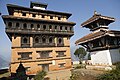
Palast

Landwirtschaftlicher Terrassenanbau nahe Duipipal

Belkot

Ortsteil von Duipipal

Kakani

Ratmate

Dhimay-Trommeln begleiten den Holzstocktanz Taktuke

Weblinks
Einzelnachweise
- ↑ General Bureau of Statistics, Kathmandu, Nepal, Nov. 2012
Achham | Arghakhanchi | Baglung | Baitadi | Bajhang | Bajura | Banke | Bara | Bardiya | Bhaktapur | Bhojpur | Chitwan | Dadeldhura | Dailekh | Dang Deukhuri | Darchula | Dhading | Dhankuta | Dhanusha | Dolakha | Dolpa | Doti | Gorkha | Gulmi | Humla | Ilam | Jajarkot | Jhapa | Jumla | Kabhrepalanchok | Kailali | Kalikot | Kanchanpur | Kapilbastu | Kaski | Kathmandu | Khotang | Lalitpur | Lamjung | Mahottari | Makwanpur | Manang | Morang | Mugu | Mustang | Myagdi | Nawalparasi (Bardaghat Susta East) | Nawalparasi (Bardaghat Susta West) | Nuwakot | Okhaldhunga | Palpa | Panchthar | Parbat | Parsa | Pyuthan | Ramechhap | Rasuwa | Rautahat | Rolpa | Rukum East | Rukum West | Rupandehi | Salyan | Sankhuwasabha | Saptari | Sarlahi | Sindhuli | Sindhupalchok | Siraha | Solukhumbu | Sunsari | Surkhet | Syangja | Tanahu | Taplejung | Terhathum | Udayapur
Auf dieser Seite verwendete Medien

Autor/Urheber: Krish Dulal, Lizenz: CC BY-SA 3.0
A festival celebrated by Newars in Nuwakot District of Nepal.

Autor/Urheber: Krishna kumar shrestha, Lizenz: CC BY-SA 3.0
This is a photo of a natural site in Nepal identified by the ID

Autor/Urheber: Krishna kumar shrestha 9803046065, Lizenz: CC BY-SA 3.0
This is a photo of a natural site in Nepal identified by the ID

(c) Karte: NordNordWest, Lizenz: Creative Commons by-sa-3.0 de
Distrikt Nuwakot in Nepal, Stand 2015

Autor/Urheber: Krishna kumar shrestha, Lizenz: CC BY-SA 3.0
This is a photo of a natural site in Nepal identified by the ID

Autor/Urheber: Krish Dulal, Lizenz: CC BY-SA 3.0
An ancient palace in Nuwakot district, Nepal.

As one of the closest and most accessible settlements to Nepal's capital city Kathmandu over 2000 meters, Kakani is a quiet hill station offering Himalayan views in the autumn. The buildings at the right edge of the photo face north onto the road running through the village. Camera location elevation is 2030 meters.
Map displaying Village Development Committees in Nuwakot District, Nepal