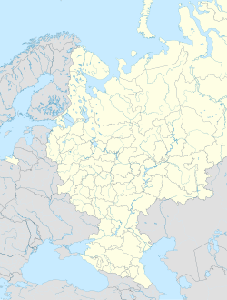
Nowokastornoje
| Siedlung städtischen Typs Nowokastornoje Новокасторное
| ||||||||||||||||||||||||||||
| ||||||||||||||||||||||||||||
| ||||||||||||||||||||||||||||
Nowokastornoje (russisch Новокасторное) ist eine Siedlung städtischen Typs im Kastorenski rajon in der Oblast Kursk im europäischen Teil Russlands mit 2014 Einwohnern (Stand 14. Oktober 2010).[1] Die Siedlung städtischen Typs besteht seit 1989.
Geschichte
Bevölkerungsentwicklung
| Jahr | Einwohner |
|---|---|
| 2002 | 2508 |
| 2009 | 2098 |
| 2010 | 2014 |
| 2012 | 1943 |
| 2013 | 1872 |
| 2014 | 1830 |
| 2015 | 1779 |
| 2016 | 1728 |
| 2017 | 1700 |
| 2018 | 1672 |
| 2019 | 1610 |
| 2020 | 1599 |
| 2021 | 2414 |
Einzelnachweise
- ↑ a b Itogi Vserossijskoj perepisi naselenija 2010 goda. Tom 1. Čislennostʹ i razmeščenie naselenija (Ergebnisse der allrussischen Volkszählung 2010. Band 1. Anzahl und Verteilung der Bevölkerung). Tabellen 5, S. 12–209; 11, S. 312–979 (Download von der Website des Föderalen Dienstes für staatliche Statistik der Russischen Föderation)
Auf dieser Seite verwendete Medien
Autor/Urheber: Uwe Dedering, Lizenz: CC BY-SA 3.0
Location map of European_Russia.
- Projection: Lambert azimuthal equal-area projection.
- Area of interest:
- N: 75.0° N
- S: 40.0° N
- W: 25.0° E
- E: 60.0° E
- Projection center:
- NS: 57.5° N
- WE: 42.5° E
- GMT projection: -JA42.5/57.5/20c
- GMT region: -R25.450860698632475/38.37411418933942/86.79037939442836/70.79910933370674r
- GMT region for grdcut: -R-2.0/38.0/87.0/76.0r
- Made with Natural Earth. Free vector and raster map data @ naturalearthdata.com.
Flag of Arms of Kursk oblast.
Autor/Urheber: Uwe Dedering, Lizenz: CC BY-SA 3.0
Location map of European_Russia.
- Projection: Lambert azimuthal equal-area projection.
- Area of interest:
- N: 75.0° N
- S: 40.0° N
- W: 25.0° E
- E: 60.0° E
- Projection center:
- NS: 57.5° N
- WE: 42.5° E
- GMT projection: -JA42.5/57.5/20c
- GMT region: -R25.450860698632475/38.37411418933942/86.79037939442836/70.79910933370674r
- GMT region for grdcut: -R-2.0/38.0/87.0/76.0r
- Made with Natural Earth. Free vector and raster map data @ naturalearthdata.com.
Autor/Urheber: Nzeemin, Lizenz: CC BY-SA 2.0
Outline map of Kursk Oblast, Russia.


