U.S. Highway 1 (Massachusetts)
 | |
|---|---|
| Karte | |
 | |
| Basisdaten | |
| Gesamtlänge: | 85,6 mi (137,8 km)[1] |
| Eröffnung: | 1930er Jahre |
| Anfangspunkt: | Rhode Island |
| Endpunkt: | New Hampshire |
| Wichtige Stadt: | Boston |
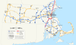
Der U.S. Highway 1 (kurz US 1) ist ein Highway, der in Nord-Süd-Richtung über eine Gesamtlänge von 3.846 km entlang der US-amerikanischen Ostküste durch mehrere Bundesstaaten von Florida bis Maine verläuft. In Massachusetts beginnt die Streckenführung im Süden an der Grenze zu Rhode Island in der Stadt Attleboro und führt in nördlicher Richtung über Boston weiter bis zur Stadt Salisbury an der Staatsgrenze zu New Hampshire.
Die Strecke südlich von Boston wird auch unter Bezeichnung Boston-Providence Turnpike geführt, während einige Teilstücke nördlich der Stadt als Northeast Expressway und Newburyport Turnpike bekannt sind.
Streckenverlauf
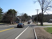
Die US 1 überquert die Staatsgrenze von Rhode Island kommend bei Attleboro und verläuft anschließend weitgehend parallel zur I-95 durch die Städte North Attleborough, Plainville, Wrentham, Foxborough, Walpole, Sharon, Norwood und Westwood.
Von dort aus verläuft die Strecke identisch mit der I-95 bis zur Kreuzung mit der I-93, mit der sie von Canton bis zum Bostoner Stadtzentrum identisch ist. Direkt nach der Überquerung der Leonard P. Zakim Bunker Hill Memorial Bridge trennt sich die US 1 wieder von der Interstate 93 und führt über die Tobin Bridge als Northeast Expressway durch die Städte Chelsea, Revere, Malden, Melrose, Saugus und Lynnfield.
Ab Lynnfield führt die US 1 wieder parallel zur I-95 durch Peabody, Danvers, Topsfield, Ipswich, Rowley, Newbury, Newburyport und Salisbury, bevor sie die Staatsgrenze nach New Hampshire überquert.
Geschichte
Die US 1 wurde in Massachusetts während der 1930er Jahre in mehreren Teilabschnitten errichtet, wobei sowohl neue Strecken gebaut als auch bereits bestehende erweitert wurden. Ein Großteil des Highways war zunächst zwei- oder dreispurig in jede Fahrtrichtung und wurde erst im Laufe der folgenden Jahre auf seine heutigen Ausmaße ausgebaut. Die Streckenführung führt teilweise über die ehemaligen Bestandteile der Lower Post Road.
Turnpikes
Der größte Teil der US 1 besteht aus den beiden ehemaligen Mautstraßen Norfolk and Bristol Turnpike und Newburyport Turnpike. Die älteren Straßen, zu denen die Turnpikes als Umgehungsstraßen konzipiert worden waren, bilden heute zu weiten Teilen die Massachusetts Route 1A.
Massachusetts Route C1
In den frühen 1930er Jahren wurde die Route C1 als Alternativstrecke zur US 1 durch das Stadtzentrum von Boston ausgewiesen, wobei der Buchstabe „C“ für Stadtstraße (englisch City Route) steht und praktisch ausschließlich im Bostoner Umfeld zum Einsatz kam. Die C1 führte entlang der Brookline Avenue, Beacon Street, der heutigen Route 28, Charles Street, Lowell Street, Merrimac Street und Cross Street bis zum westlichen Ende des Sumner-Tunnels.
In East Boston führte die Strecke weiter über die Porter Street und Chelsea Street auf die heutige Route 1A. Mit der Eröffnung des Storrow Drive und der Central Artery in den 1950er Jahren wurde die C1 verlegt, so dass sie teilweise auf diesen neuen Straßen verlief. Im Jahr 1971 wurde die C1 aufgelöst, wobei der Teil südlich des Charles River im Wesentlichen der US 1 und der Teil nördlich des Flusses zum größten Teil der Route 1A zugeteilt wurde. Der Verlauf der US 1 wurde später auf den Southeast Expressway verlagert, so dass heute die ehemalige Strecke der C1 südlich des Flusses keine Nummerierung mehr aufweist.
Verlagerung der Streckenführung in Boston
Die US 1 war auf dem Stadtgebiet von Boston bis in die 1970er Jahre hinein ein Ersatz für die ursprünglich geplante Trasse der I-95 entlang des Northeast Expressway nördlich des Stadtzentrums.[2] In den späten 1980er Jahren wurde die US 1 in Erwartung der Fußball-Weltmeisterschaft 1994 auf die I-93 verlegt, so dass die alte Streckenführung über den VFW Parkway, Jamaicaway, Riverway und Storrow Drive durch Dedham, Brookline, West Roxbury und weitere Bostoner Stadtteile seither nicht mehr nummeriert ist.
Northeast Expressway
Der Northeast Expressway befindet sich nördlich des Bostoner Stadtzentrums und verläuft von der Kreuzung zwischen I-93 und US 1 in Charlestown über den Mystic River durch Chelsea und Revere. Während er zu Beginn aufgeständert ist, verläuft er ab dem nördlichen Chelsea ebenerdig und endet an der Grenze zwischen Revere und Saugus.
Ursprünglich sahen die Pläne vor, die Straße in Richtung Norden von Saugus ausgehend über Lynn und Lynnfield bis Peabody zu verlängern, um an der heutigen Kreuzung zwischen der I-95 und Route 128 in Peabody zu enden. Von 1955 bis 1973 war die Strecke in Erwartung des letztlich jedoch nie erfolgten Ausbaus als I-95 ausgewiesen.[2]
Liste der Ausfahrten
| County | Ort | Entfernung | Anschlussverbindungen | Bemerkungen |
|---|---|---|---|---|
| Staatsgrenze zu Rhode Island Die US 1 führt weiter nach Pawtucket. | ||||
| Bristol County | Attleboro | 0,3 mi (0,5 km) | Ausfahrt nur in südlicher und Zufahrt nur in nördlicher Fahrtrichtung | |
| 1,8 mi (2,9 km) | ||||
| 2,0 mi (3,2 km) | Beginn des (nicht beschilderten) identischen Verlaufs mit der Route 1A | |||
| North Attleborough | 4,0 mi (6,4 km) | |||
| 5,2 mi (8,4 km) | Östliches Ende der Route 120 | |||
| 7,4 mi (11,9 km) | Ende des (nicht beschilderten) identischen Verlaufs mit der Route 1A | |||
| Norfolk County | Plainville | 8,4 mi (13,5 km) | ||
| 10,0 mi (16,1 km) | Nördliches Ende der Route 152 | |||
| 10,6 mi (17,1 km) | ||||
| Foxborough | 13,6 mi (21,9 km) | Keine Direktverbindung zur Route 140 | ||
| Sharon | 18,3 mi (29,5 km) | Ausfahrt nur in südlicher und Zufahrt nur in nördlicher Fahrtrichtung | ||
| 18,4 mi (29,6 km) | Ausfahrt nur in nördlicher und Zufahrt nur in südlicher Fahrtrichtung | |||
| Walpole | 19,1 mi (30,7 km) | |||
| Westwood | 25,9 mi (41,7 km) | Beginn des identischen Verlaufs mit der I-95 / Route 128 | ||
| 26,6 mi (42,8 km) | Canton Street, East Street | Kreisverkehr | ||
| Dedham | 27,8 mi (44,7 km) | University Avenue / MBTA- und Amtrak-Station | ||
| Canton | 28,2 mi (45,4 km) | Beginn des identischen Verlaufs mit der I-93 an deren südlichem Ende. Ende des identischen Verlaufs mit der I-95 und Route 128. | ||
| 29,6 mi (47,6 km) | ||||
| Milton | 30,8 mi (49,6 km) | Ponkapoag Trail, Houghton’s Pond | ||
| Randolph | 31,7 mi (51 km) | Fall River Expressway / Amvets Highway | ||
| 32,4 mi (52,1 km) | ||||
| Braintree | 34,6 mi (55,7 km) | |||
| 35,3 mi (56,8 km) | Zufahrt von der Route 3 nur in nördlicher und Abfahrt auf die Route 3 nur in südlicher Fahrtrichtung | |||
| Quincy | 36,4 mi (58,6 km) | Furnace Brook Parkway – Quincy | ||
| Milton | 37,5 mi (60,4 km) | Bryant Avenue – West Quincy | Ausfahrt nur in südlicher und Zufahrt nur in nördlicher Fahrtrichtung | |
| 37,6 mi (60,5 km) | Adams Street – Milton, North Quincy | Ausfahrt nur in nördlicher und Zufahrt nur in südlicher Fahrtrichtung | ||
| 37,8 mi (60,8 km) | Squantum Street – Milton | Nur Ausfahrt in südlicher Fahrtrichtung | ||
| 39,1 mi (62,9 km) | Granite Avenue – East Milton | Ausfahrt nur in südlicher und Zufahrt nur in nördlicher Fahrtrichtung | ||
| 39,1 mi (62,9 km) | Ausgewiesen als Ausfahrt 11 in nördlicher Fahrtrichtung. Keine Zufahrt in nördlicher Fahrtrichtung. | |||
| Suffolk County | Boston | 40,0 mi (64,4 km) | Ausfahrt nur in südlicher und Zufahrt nur in nördlicher Fahrtrichtung | |
| 40,8 mi (65,7 km) | Freeport Street – Dorchester | Ausfahrt nur in nördlicher und Zufahrt nur in südlicher Fahrtrichtung | ||
| 41,1 mi (66,1 km) | Morrissey Boulevard – John F. Kennedy Presidential Library and Museum | Ausfahrt nur in nördlicher und Zufahrt nur in südlicher Fahrtrichtung | ||
| 42,6 mi (68,6 km) | Columbia Road – John F. Kennedy Presidential Library and Museum | |||
| 43,3 mi (69,7 km) | Southampton Street | Ausfahrt nur in nördlicher und Zufahrt nur in südlicher Fahrtrichtung | ||
| 43,7 mi (70,3 km) | Frontage Road, Massachusetts Avenue – Roxbury | |||
| 44,5 mi (71,6 km) | Ausfahrt nur in nördlicher und Zufahrt nur in südlicher Fahrtrichtung | |||
| 44,5 mi (71,6 km) | Ausfahrt nur in südlicher und Zufahrt nur in nördlicher Fahrtrichtung. Zugleich Zufahrt über die I-90 auf die I-93 North. | |||
| 45,6 mi (73,4 km) | Purchase Street | Keine Ausfahrt in nördlicher Fahrtrichtung | ||
| 45,9 mi (73,9 km) | Government Center | Ausgewiesen als Ausfahrt Nr. 23 in nördlicher Fahrtrichtung | ||
| 46,1 mi (74,2 km) | Ausfahrt nur in südlicher und Zufahrt nur in nördlicher Fahrtrichtung | |||
| 46,3 mi (74,5 km) | Nördliches Ende des identischen Verlaufs mit der Route 3 | |||
| 46,5 mi (74,8 km) | Ende des identischen Verlaufs mit der I-93 | |||
| Chelsea | 48,4 mi (77,9 km) | Beacon Street, Everett Avenue | Ausfahrt nur in nördlicher und Zufahrt nur in südlicher Fahrtrichtung | |
| 49,0 mi (78,9 km) | Fourth Street | Nur Ausfahrt in nördlicher Fahrtrichtung | ||
| 49,3 mi (79,3 km) | Fifth Street | Nur Zufahrt in südlicher Fahrtrichtung | ||
| 49,7 mi (80 km) | Sixth Street | Nur Zufahrt in nördlicher Fahrtrichtung | ||
| 49,9 mi (80,3 km) | Carter Street | Ausfahrt und Zufahrt nur in südlicher Fahrtrichtung | ||
| 50,1 mi (80,6 km) | Zufahrt von der Route 16 zur US 1 nur in südlicher Fahrtrichtung | |||
| 50,3 mi (81 km) | Webster Street | Nur Ausfahrt in nördlicher Fahrtrichtung | ||
| 50,5 mi (81,3 km) | Ausfahrt und Zufahrt nur in nördlicher Fahrtrichtung | |||
| Revere | 50,8 mi (81,8 km) | Ausfahrt und Zufahrt nur in südlicher Fahrtrichtung | ||
| 51,8 mi (83,4 km) | Sargent Street | Ausfahrt nur in nördlicher und Zufahrt nur in südlicher Fahrtrichtung | ||
| 52,4 mi (84,3 km) | Nur Ausfahrt in nördlicher Fahrtrichtung | |||
| 52,8 mi (85 km) | Nur Ausfahrt in südlicher Fahrtrichtung | |||
| 53,1 mi (85,5 km) | Salem Street | Keine Zufahrt in nördlicher Fahrtrichtung | ||
| Essex County | Saugus | 54,5 mi (87,7 km) | Nördliches Ende der Route 99 | |
| 54,8 mi (88,2 km) | Essex Street | |||
| 55,3 mi (89 km) | Main Street | |||
| 56,5 mi (90,9 km) | Lynn Fells Parkway | |||
| 57,1 mi (91,9 km) | Beginn des identischen Verlaufs mit der Route 129 | |||
| Lynnfield | 58,8 mi (94,6 km) | Ende des identischen Verlaufs mit der Route 129 | ||
| Peabody | 59,5 mi (95,8 km) | Nur Ausfahrt in nördlicher Fahrtrichtung | ||
| 60,1 mi (96,7 km) | Ausfahrt nur in südlicher und Zufahrt nur in nördlicher Fahrtrichtung | |||
| 61,0 mi (98,2 km) | Ausfahrt nur in südlicher und Zufahrt nur in nördlicher Fahrtrichtung | |||
| 61,6 mi (99,1 km) | Lowell Street | |||
| Danvers | 62,5 mi (100,6 km) | In östlicher Fahrtrichtung Anschluss an die | ||
| 63,2 mi (101,7 km) | Centre Street | In östlicher Fahrtrichtung Anschluss an die | ||
| 64,2 mi (103,3 km) | In östlicher Fahrtrichtung Anschluss an die | |||
| 65,0 mi (104,6 km) | Letzte direkte Verbindung zwischen der US 1 und der I-95 in Massachusetts | |||
| Topsfield | 68,1 mi (109,6 km) | |||
| 69,3 mi (111,5 km) | Ipswich Road | |||
| Ipswich | 71,8 mi (115,6 km) | Linebrook Road | ||
| Rowley | 73,1 mi (117,6 km) | |||
| Newburyport | 80,0 mi (128,7 km) | Kreisverkehr | ||
| 80,9 mi (130,2 km) | Summer Street / Winter Street | Ausfahrt nur in nördlicher und Zufahrt nur in südlicher Fahrtrichtung | ||
| 81,1 mi (130,5 km) | Beginn des nicht ausgewiesenen identischen Verlaufs mit der Route 1A | |||
| Salisbury | 81,6 mi (131,3 km) | Friedenfels Street | ||
| 83,0 mi (133,6 km) | Östliches Ende der Route 110 | |||
| 83,1 mi (133,7 km) | Ende des nicht ausgewiesenen identischen Verlaufs mit der Route 1A | |||
| 84,6 mi (136,2 km) | Toll Road – Anschluss zur | |||
| 85,3 mi (137,3 km) | ||||
| Staatsgrenze zu New Hampshire Die US 1 führt weiter nach Seabrook. | ||||
Einzelnachweise
- ↑ Road Inventory. (Nicht mehr online verfügbar.) Massachusetts Department of Transportation, archiviert vom Original am 20. Juni 2012; abgerufen am 25. Oktober 2012 (englisch). Info: Der Archivlink wurde automatisch eingesetzt und noch nicht geprüft. Bitte prüfe Original- und Archivlink gemäß Anleitung und entferne dann diesen Hinweis.
- ↑ a b Northeast Expressway. bostonroads.com, abgerufen am 26. Oktober 2012 (englisch).
Auf dieser Seite verwendete Medien
600 mm × 600 mm (24 in × 24 in) U.S. Highway shield, made to the specifications of the 2004 edition of Standard Highway Signs. (Note that there is a missing "J" label on the left side of the diagram.) Uses the Roadgeek 2005 fonts. (United States law does not permit the copyrighting of typeface designs, and the fonts are meant to be copies of a U.S. Government-produced work anyway.)
600 mm by 600 mm (24 in by 24 in) Massachusetts Route shield, made to the specifications of the 1996 edition of Construction and Traffic Standard Details (sign M1-5). Uses the Roadgeek 2005 fonts. (United States law does not permit the copyrighting of typeface designs, and the fonts are meant to be copies of a U.S. Government-produced work anyway.) The outside border has a width of 1 (1 mm) and a color of black so it shows up; in reality, signs have no outside border. The specs actually do not show the curve on the outside border, instead making it a perfect square, but all signs I have seen round the corners.
750 mm by 600 mm (30 in by 24 in) Massachusetts Route shield, made to the specifications of the 1996 edition of Construction and Traffic Standard Details (sign M1-5). Uses the Roadgeek 2005 fonts. (United States law does not permit the copyrighting of typeface designs, and the fonts are meant to be copies of a U.S. Government-produced work anyway.) The outside border has a width of 1 (1 mm) and a color of black so it shows up; in reality, signs have no outside border. The specs actually do not show the curve on the outside border, instead making it a perfect rectangle, but all signs I have seen round the corners.
Official highway sign placed along many state highways indicating a corporate boundary. This sign indicates entering the city of Boston.
Autor/Urheber: John Phelan, Lizenz: CC BY 3.0
Looking south on US Route 1, Topsfield Massachusetts
Autor/Urheber: Sswonk, Lizenz: CC BY-SA 3.0
Map of major highways in Massachusetts with U.S. Route 1 highlighted in red
750 mm by 600 mm (30 in by 24 in) Massachusetts Route shield, made to the specifications of the 1996 edition of Construction and Traffic Standard Details (sign M1-5). Uses the Roadgeek 2005 fonts. (United States law does not permit the copyrighting of typeface designs, and the fonts are meant to be copies of a U.S. Government-produced work anyway.) The outside border has a width of 1 (1 mm) and a color of black so it shows up; in reality, signs have no outside border. The specs actually do not show the curve on the outside border, instead making it a perfect rectangle, but all signs I have seen round the corners. Note: The specs specify Series D font for the numbers. However, that font does not fit when none of the characters is a one, and so those signs actually use Series C. This image is true to real signs, not the specs.
750 mm by 600 mm (30 in by 24 in) Massachusetts Route shield, made to the specifications of the 1996 edition of Construction and Traffic Standard Details (sign M1-5). Uses the Roadgeek 2005 fonts. (United States law does not permit the copyrighting of typeface designs, and the fonts are meant to be copies of a U.S. Government-produced work anyway.) The outside border has a width of 1 (1 mm) and a color of black so it shows up; in reality, signs have no outside border. The specs actually do not show the curve on the outside border, instead making it a perfect rectangle, but all signs I have seen round the corners.
750 mm by 600 mm (30 in by 24 in) Massachusetts Route shield, made to the specifications of the 1996 edition of Construction and Traffic Standard Details (sign M1-5). Uses the Roadgeek 2005 fonts. (United States law does not permit the copyrighting of typeface designs, and the fonts are meant to be copies of a U.S. Government-produced work anyway.) The outside border has a width of 1 (1 mm) and a color of black so it shows up; in reality, signs have no outside border. The specs actually do not show the curve on the outside border, instead making it a perfect rectangle, but all signs I have seen round the corners.
750 mm by 600 mm (30 in by 24 in) Massachusetts Route shield, made to the specifications of the 1996 edition of Construction and Traffic Standard Details (sign M1-5). Uses the Roadgeek 2005 fonts. (United States law does not permit the copyrighting of typeface designs, and the fonts are meant to be copies of a U.S. Government-produced work anyway.) The outside border has a width of 1 (1 mm) and a color of black so it shows up; in reality, signs have no outside border. The specs actually do not show the curve on the outside border, instead making it a perfect rectangle, but all signs I have seen round the corners.
600 mm by 600 mm (24 in by 24 in) Massachusetts Route shield, made to the specifications of the 1996 edition of Construction and Traffic Standard Details (sign M1-5). Uses the Roadgeek 2005 fonts. (United States law does not permit the copyrighting of typeface designs, and the fonts are meant to be copies of a U.S. Government-produced work anyway.) The outside border has a width of 1 (1 mm) and a color of black so it shows up; in reality, signs have no outside border. The specs actually do not show the curve on the outside border, instead making it a perfect square, but all signs I have seen round the corners.
600 mm by 600 mm (24 in by 24 in) Massachusetts Route shield, made to the specifications of the 1996 edition of Construction and Traffic Standard Details (sign M1-5). Uses the Roadgeek 2005 fonts. (United States law does not permit the copyrighting of typeface designs, and the fonts are meant to be copies of a U.S. Government-produced work anyway.) The outside border has a width of 1 (1 mm) and a color of black so it shows up; in reality, signs have no outside border. The specs actually do not show the curve on the outside border, instead making it a perfect square, but all signs I have seen round the corners.
750 mm by 600 mm (30 in by 24 in) Massachusetts Route shield, made to the specifications of the 1996 edition of Construction and Traffic Standard Details (sign M1-5). Uses the Roadgeek 2005 fonts. (United States law does not permit the copyrighting of typeface designs, and the fonts are meant to be copies of a U.S. Government-produced work anyway.) The outside border has a width of 1 (1 mm) and a color of black so it shows up; in reality, signs have no outside border. The specs actually do not show the curve on the outside border, instead making it a perfect rectangle, but all signs I have seen round the corners. Note: The specs specify Series D font for the numbers. However, that font does not fit when none of the characters is a one, and so those signs actually use Series C. This image is true to real signs, not the specs.
600 mm by 600 mm (24 in by 24 in) Massachusetts Route shield, made to the specifications of the 1996 edition of Construction and Traffic Standard Details (sign M1-5). Uses the Roadgeek 2005 fonts. (United States law does not permit the copyrighting of typeface designs, and the fonts are meant to be copies of a U.S. Government-produced work anyway.) The outside border has a width of 1 (1 mm) and a color of black so it shows up; in reality, signs have no outside border. The specs actually do not show the curve on the outside border, instead making it a perfect square, but all signs I have seen round the corners.
750 mm by 600 mm (30 in by 24 in) Massachusetts Route shield, made to the specifications of the 1996 edition of Construction and Traffic Standard Details (sign M1-5). Uses the Roadgeek 2005 fonts. (United States law does not permit the copyrighting of typeface designs, and the fonts are meant to be copies of a U.S. Government-produced work anyway.) The outside border has a width of 1 (1 mm) and a color of black so it shows up; in reality, signs have no outside border. The specs actually do not show the curve on the outside border, instead making it a perfect rectangle, but all signs I have seen round the corners.
600 mm by 600 mm (24 in by 24 in) Massachusetts Route shield, made to the specifications of the 1996 edition of Construction and Traffic Standard Details (sign M1-5). Uses the Roadgeek 2005 fonts. (United States law does not permit the copyrighting of typeface designs, and the fonts are meant to be copies of a U.S. Government-produced work anyway.) The outside border has a width of 1 (1 mm) and a color of black so it shows up; in reality, signs have no outside border. The specs actually do not show the curve on the outside border, instead making it a perfect square, but all signs I have seen round the corners.
600 mm by 600 mm (24 in by 24 in) Massachusetts Route shield, made to the specifications of the 1996 edition of Construction and Traffic Standard Details (sign M1-5). Uses the Roadgeek 2005 fonts. (United States law does not permit the copyrighting of typeface designs, and the fonts are meant to be copies of a U.S. Government-produced work anyway.) The outside border has a width of 1 (1 mm) and a color of black so it shows up; in reality, signs have no outside border. The specs actually do not show the curve on the outside border, instead making it a perfect square, but all signs I have seen round the corners.
600 mm by 600 mm (24 in by 24 in) Massachusetts Route shield, made to the specifications of the 1996 edition of Construction and Traffic Standard Details (sign M1-5). Uses the Roadgeek 2005 fonts. (United States law does not permit the copyrighting of typeface designs, and the fonts are meant to be copies of a U.S. Government-produced work anyway.) The outside border has a width of 1 (1 mm) and a color of black so it shows up; in reality, signs have no outside border. The specs actually do not show the curve on the outside border, instead making it a perfect square, but all signs I have seen round the corners.
750 mm by 600 mm (30 in by 24 in) Massachusetts Route shield, made to the specifications of the 1996 edition of Construction and Traffic Standard Details (sign M1-5). Uses the Roadgeek 2005 fonts. (United States law does not permit the copyrighting of typeface designs, and the fonts are meant to be copies of a U.S. Government-produced work anyway.) The outside border has a width of 1 (1 mm) and a color of black so it shows up; in reality, signs have no outside border. The specs actually do not show the curve on the outside border, instead making it a perfect rectangle, but all signs I have seen round the corners.
600 mm by 600 mm (24 in by 24 in) Massachusetts Route shield, made to the specifications of the 1996 edition of Construction and Traffic Standard Details (sign M1-5). Uses the Roadgeek 2005 fonts. (United States law does not permit the copyrighting of typeface designs, and the fonts are meant to be copies of a U.S. Government-produced work anyway.) The outside border has a width of 1 (1 mm) and a color of black so it shows up; in reality, signs have no outside border. The specs actually do not show the curve on the outside border, instead making it a perfect square, but all signs I have seen round the corners.
750 mm by 600 mm (30 in by 24 in) Massachusetts Route shield, made to the specifications of the 1996 edition of Construction and Traffic Standard Details (sign M1-5). Uses the Roadgeek 2005 fonts. (United States law does not permit the copyrighting of typeface designs, and the fonts are meant to be copies of a U.S. Government-produced work anyway.) The outside border has a width of 1 (1 mm) and a color of black so it shows up; in reality, signs have no outside border. The specs actually do not show the curve on the outside border, instead making it a perfect rectangle, but all signs I have seen round the corners.
750 mm by 600 mm (30 in by 24 in) Massachusetts Route shield, made to the specifications of the 1996 edition of Construction and Traffic Standard Details (sign M1-5). Uses the Roadgeek 2005 fonts. (United States law does not permit the copyrighting of typeface designs, and the fonts are meant to be copies of a U.S. Government-produced work anyway.) The outside border has a width of 1 (1 mm) and a color of black so it shows up; in reality, signs have no outside border. The specs actually do not show the curve on the outside border, instead making it a perfect rectangle, but all signs I have seen round the corners.
750 mm by 600 mm (30 in by 24 in) Massachusetts Route shield, made to the specifications of the 1996 edition of Construction and Traffic Standard Details (sign M1-5). Uses the Roadgeek 2005 fonts. (United States law does not permit the copyrighting of typeface designs, and the fonts are meant to be copies of a U.S. Government-produced work anyway.) The outside border has a width of 1 (1 mm) and a color of black so it shows up; in reality, signs have no outside border. The specs actually do not show the curve on the outside border, instead making it a perfect rectangle, but all signs I have seen round the corners.
600 mm by 600 mm (24 in by 24 in) Massachusetts Route shield, made to the specifications of the 1996 edition of Construction and Traffic Standard Details (sign M1-5). Uses the Roadgeek 2005 fonts. (United States law does not permit the copyrighting of typeface designs, and the fonts are meant to be copies of a U.S. Government-produced work anyway.) The outside border has a width of 1 (1 mm) and a color of black so it shows up; in reality, signs have no outside border. The specs actually do not show the curve on the outside border, instead making it a perfect square, but all signs I have seen round the corners.
