Northamptonshire
| Grafschaft Northamptonshire | |||
|---|---|---|---|
| |||
| Wahlspruch: Rosa concordia signum (Die Rose – ein Symbol der Harmonie) | |||
 | |||
| Staat | Vereinigtes Königreich | ||
| Landesteil | England | ||
| Region | East Midlands | ||
| Status | Zeremonielle | ||
| Ersterwähnung | 1011 (als Hamtunscire) | ||
| Zeremonielle Grafschaft | |||
| Fläche | 2.364 km² | ||
| Einwohner | 747.622 | ||
| Stand | 30. Juni 2018[1] | ||
| Distrikte / Unitary Authorities | |||
Northamptonshire [] (abgekürzt Northants) ist eine (traditionelle und zeremonielle) Grafschaft (County) in den East Midlands von England. Northamptonshire grenzt an Warwickshire, Leicestershire, Rutland, Cambridgeshire (mit Peterborough), Bedfordshire, Buckinghamshire (mit Milton Keynes), Oxfordshire und mit einer sehr kurzen Grenze (19 Meter) an Lincolnshire.
Bis zum 1. April 2021 war Northamptonshire eine Verwaltungsgrafschaft (non-metropolitan county), die aus sieben Districts bestand. Der Verwaltungssitz befand sich in Northampton. Am 1. April 2021 wurde die zweistufige Verwaltung von einer einstufigen abgelöst. Die Grafschafts- und Distriktsverwaltungen wurden zu zwei Unitary Authorities zusammengefasst: North Northamptonshire und West Northamptonshire.[2]
Der Soke of Peterborough gehörte früher zu Northamptonshire.
Geographie
Northamptonshire ist eine Grafschaft im Landesinnern ohne direkten Zugang zur Küste im südlichen Teil der East Midlands,[3] der gelegetlich als South Midlands bezeichnet wird. Die Grafschaft schließt die Wasserscheide zwischen dem River Severn uand The Wash, und mehrere wichtige Flüse haben ihre Quellen im Nordwesten der Grafschaft, darunter der River Nene, der in nordöstlicher Richtung zum Wash fließt und dem Warwickshire Avon, der nach Südwesten fließt und in den Severn mündet. Im Jahr 1830 wurde gesagt, dass „nicht ein einziger Bach, sei er noch so unbedeutend, aus einem anderen Bezirk nach Northamptonshire fließt“.[4] Im Westen der Grafschaft befindet sich das Bergland, das meist als die Northamptonshire Uplands genannt wird; hier befindet sich auch der höchste Punkt der Grafschaft, der 225 m ASL hohe Arbury Hill, der direkt südlich von Daventry liegt.[5][6] Die Grenze mit Lincolnshire ist mit einer Länge von etwa 18 m Englands kürzeste Grenze zwischen zwei zeremoniellen Grafschaften in England.[7]
Von den Towns in der Grafschaft ist Northampton die größte und einwohnerreichst. Zum Zeitpunkt der Volkszählung von 2011 hatte Northamptonshire 691.952 Einwohner, wovon 212.069 in Northampton lebten. Die nachfolgende Tabelle nennt alle Towns mit mehr als 10.000 Einwohnern.
| Rang | Town | Einwohnerzahl | Früherer Borough/District Council |
|---|---|---|---|
| 1 | Northampton | 249.093 (2021) | Northampton Borough Council |
| 2 | Corby | 75.571 (2021) | Corby Borough Council |
| 3 | Kettering | 63.150 (2021) | Kettering Borough Council |
| 4 | Wellingborough | 56.564 (2021) | Borough Council of Wellingborough |
| 5 | Rushden | 31-690 (2021) | East Northamptonshire District Council |
| 6 | Daventry | 28.123 (2021) | Daventry District Council |
| 7 | Brackley | 16.159 (2021) | South Northamptonshire District Council |
| 8 | Towcester | 11.524 (2021) | South Northamptonshire District Council |
2010 gab es 16 Towns in Northamptonshire:
- Brackley, Burton Latimer, Corby, Daventry, Desborough, Higham Ferrers, Irthlingborough, Kettering, Northampton, Oundle, Raunds, Rothwell, Rushden, Towcester, Thrapston und Wellingborough.
Contains Ordnance Survey data © Crown copyright and database right, CC BY-SA 3.0 |
Ein paar Orte |
Städte und Ortschaften
- Aldwincle Apethorpe, Aynho
- Barnwell, Brackley, Braunston, Brigstock, Brixworth, Broughton, Burton Latimer
- Canons Ashby, Castle Ashby, Charlton, Collyweston, Corby, Crick
- Daventry, Desborough
- Earls Barton
- Fotheringhay
- Geddington, Grafton Underwood, Great Addington, Greatworth, Gretton
- Harpole, Harringworth
- Irchester, Islip
- Kelmarsh, Kettering, Kislingbury
- Lowick
- Marston St. Lawrence, Middleton, Moulton
- Naseby, Nassington, Nether Heyford, Northampton
- Oundle
- Pilton
- Raunds, Rothwell, Rushden
- Silverstone, Slapton
- Tansor, Thorpe Waterville, Thrapston, Towcester
- Upper Boddington, Upton
- Welford, Wellingborough, Whitfield, Wollaston
- Yelvertoft
Sehenswürdigkeiten
- Althorp House, Sitz des Earl Spencer
- Apethorpe Palace, Herrenhaus aus dem 15. Jahrhundert
- Astwell Castle
- Aynhoe Park
- Barnwell Castle
- Boughton House, Sitz der Herzöge von Buccleuch
- Burghley House
- Bury Mount
- Canons Ashby House (16. Jahrhundert) und Canons Ashby Priory (1150)
- Castle Ashby House
- Coton Manor Gardens
- Cracks Hill, Hügel nahe Crick
- Cottesbrooke Hall
- Deene Park, Herrenhaus aus dem 14. Jahrhundert in Deene nahe Corby
- Delapré Abbey
- Elton Hall
- East Haddon Hall
- Fotheringhay Castle
- Jesus Hospital, Rothwell
- Kelmarsh Hall, Herrenhaus in Kelmarsh
- Kirby Hall, Teil des English Heritage
- Lyvden New Bield, Herrenhaus in Aldwincle, Eigentum des National Trust
- Rockingham Castle
- Rockingham Motor Speedway
- Rushton Triangular Lodge, Teil des English Heritage
- Silverstone Circuit
- Stanford Hall
- Welland Valley Viaduct
Verwaltungsgliederung 1974 bis 2021

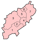
Bis zum 1. April 2021 gliederte sich Northamptonshire in die sieben Districts South Northamptonshire (1), Northampton (2), Daventry (3), Wellingborough (4), Kettering (5), Corby (6) und East Northamptonshire (7). Die ersten drei Distrikte wurden im Wesentlichen zur Unitary Authority of West Northamptonshire und die letzten drei zur Unitary Authority of North Northamptonshire zusammengefasst.
Weblinks
Einzelnachweise
- ↑ Mid 2018 Estimates of the population for the UK, England and Wales, Scotland and Northern Ireland
- ↑ legislation.gov.uk: The Northamptonshire (Structural Changes) Order 2020. Abgerufen am 2. April 2021 (englisch).
- ↑ Official information on visiting and holidaying in Northamptonshire. Archiviert vom am 12. März 2007; abgerufen am 25. Mai 2025 (englisch).
- ↑ UK Genealogy Archives: Transcript from Pigot & Co's Commercial Directory, 1830 ( vom 2. Januar 2016 im Internet Archive) (englisch). Abgerufen am 31. Mai 2025.
- ↑ Bathurst 2012, S. 56–59
- ↑ Northamptonshire Genealogy: Bartholomew's Gazetteer of the British Isles, 1887 ( vom 12. Juni 2009 im Internet Archive). Abgerufen am 25. Mai 2025.
- ↑ Lincolnshire County Council. Thebythams.org.uk, 24. Oktober 2005, archiviert vom am 6. Mai 2009; abgerufen am 25. Mai 2025 (englisch).
Koordinaten: 52° 18′ 0″ N, 0° 51′ 0″ W
Auf dieser Seite verwendete Medien
Contains Ordnance Survey data © Crown copyright and database right, CC BY-SA 3.0
Map of Northamptonshire, UK with districts shown.
Equirectangular map projection on WGS 84 datum, with N/S stretched 160%
Geographic limits:
- West: 1.35W
- East: 0.33W
- North: 52.67N
- South: 51.94N
Shiny orange button/marker widget.
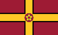
The flag of the historic county of Northamptonshire, registered by the Flag Institute
Autor/Urheber: TUBS
Lage der ländlichen Grafschaft XY (siehe Dateiname) in England.
(c) Nilfanion, CC BY 3.0
Numbered districts of Northamptonshire county, from 2021. Derived from File:Northamptonshire UK district map (blank).svg, by Nilfanion.


