North Yorkshire (Unitary Authority)
| North Yorkshire | |
|---|---|
Contains Ordnance Survey data © Crown copyright and database right, CC BY-SA 3.0 | |
| Status | Unitary Authority |
| Region | Yorkshire and the Humber |
| Zerem. Grafschaft | North Yorkshire |
| Verwaltungssitz | Northallerton |
| Fläche | 8038 km² |
| Einwohner | 614.505 |
| Stand | 30. Juni 2018[1] |
| ISO-3166-2 | GB-NYK |
| ONS-Code | 36 |
| GSS-Code | E10000023 |
| Website | www.northyorks.gov.uk |
| Gründung | 1. April 2023 |
North Yorkshire [] ist eine Unitary Authority in der Region Yorkshire and the Humber in England. Die Unitary Authority grenzt an East Riding of Yorkshire, South Yorkshire, West Yorkshire, Lancashire, Westmorland and Furness, County Durham, Darlington, Stockton-on-Tees, Middlesbrough, Redcar and Cleveland und York.
In North Yorkshire liegen zwei der elf Nationalparks von England und Wales, nämlich der North York Moors National Park und der größte Teil der Yorkshire Dales.
Geschichte
North Yorkshire war bis zum 1. April 2023 ein Non-Metropolitan County, das in die Distrikte Craven, Hambleton, Harrogate, Richmondshire, Ryedale, Scarborough und Selby unterteilt war.
Städte und Orte
- Appletreewick, Arncliffe, Askrigg, Askwith, Austwick, Aysgarth
- Bainbridge, Beadlam, Beal, Bedale, Bentham, Bolton Abbey, Boroughbridge, Borrowby, Braidley, Burnsall, Burton-in-Lonsdale, Buttercrambe
- Caldbergh, Carlton, Castleton, Catterick, Catterick Bridge, Cawood, Chapel-le-Dale, Chop Gate, Church Houses, Clapham, Cloughton, Cockayne, Cold Kirby, Commondale, Conistone, Cotterdale, Coverham, Coxwold, Crayke, Cropton
- Dalton, Dalton-on-Tees, Denton, Downholme
- Easingwold, East Witton, Egton, Egton Bridge, Embsay, Eshton
- Farlington, Fewston, Filey, Flaxton, Fountains
- Gargrave, Gayle, Giggleswick, Gilling, Glaisdale, Goathland, Grassington, Great Adstone, Great Ayton, Grewelthorpe, Grinton, Grosmont, Gunnerside
- Hardraw, Harome, Harrogate, Hawes, Hawkswick, Hawnby, Hebden, Helmsley, Helperby, Helwith, Hempsthwaite, Hillam, Horsehouse, Horton in Ribblesdale, Hovingham, Hubberholme, Hutton-le-Hole
- Ingleby Arncliffe, Ingleton, Ivelet
- Jervaulx
- Keld, Kettlewell, Kildwick, Kilnsey, Kirkby Malham, Kirkby Malzeard, Kirkbymoorside, Kirkham, Kirklington, Knaresborough
- Langthwaite, Lastingham, Laverton, Lealholm, Leavening, Levisham, Leyburn, Linton, Little Stainforth, Litton, Long Marston, Lund
- Malham, Malham Moor, Malton, Markington, Marrick, Masham, Melmerby, Middleham, Middlesmoor, Middleton, Muker
- Newsham, Northallerton, Nunnington
- Osmotherley, Oughtershaw
- Pateley Bridge, Pickering
- Rainton, Ramsgill, Ravenscar, Ravensworth, Redmire, Reeth, Richmond, Rievaulx, Ripley, Ripon, Robin Hood’s Bay, Rosedale Abbey, Runswick Bay
- Salton, Scarborough, Scawton, Scorton, Seave Green, Selby, Settle, Sicklinghall, Skelton, Skipton, Slingsby, South Milford, Sowerby, Stainforth, Staithes, Starbotton, Stokesley, Summerbridge, Swineside
- Tadcaster, Terrington, Thirsk, Thoralby, Thornton Dale, Thwaite, Topcliffe, Tosside
- Warthill, Wass, Wath, Wensley, West Burton, West Scrafton, West Whitton, Westow, Wharram Percy, Whaw, Whitby, Whitwell-on-the-Hill, Wigglesworth, Wistow, Wombleton, Woodale, Woodhall, Wrelton
- Yockenthwaite
Sehenswürdigkeiten

- All Saints, Kirkbymoorside
- Ampleforth College
- Austwick Beck
- Aysgarth-Wasserfälle
- Aysgill Force
- Beck Isle Museum, Pickering
- Bolton Abbey
- Bolton Castle
- Burton-in-Lonsdale Castle
- Buttercrambe Castle
- Byland Abbey
- Castle Howard
- Catrigg Force
- Catterick Camp
- Cauldron Falls
- Cawood Castle
- Coverham Abbey
- Gray Gill
- Crayke Castle
- Currack Force
- Drax
- Duncombe Park
- Fountains Abbey
- Gaping Gill
- Gilling Castle
- Helmsley Castle
- Ingleborough Cave
- Ingleby Manor
- Janet’s Foss
- Jervaulx Abbey
- Kilnsey Crag
- Kiplin Hall
- Kirkham Priory
- Kisdon Force
- Knaresborough Castle
- Malham Cove
- Markenfield Hall
- Malton Castle
- Mount Grace Priory
- Mulgrave Castle
- North Yorkshire Moors Railway
- Pickering Castle
- Ravensworth Castle
- Ribblehead-Viadukt
- Richmond Castle
- Rievaulx Abbey
- River Esk
- Ryedale Folk Museum
- Shandy Hall
- Sheriff Hutton Castle
- Skipton Castle
- St. Gregory’s Minster, Kirkdale
- St. Mary’s Church, Lastingham
- St. Mary’s Church, Whitby
- St. Nicholas Church, Bransdale
- St. Peter and Paul Church in Pickering
- Stainforth Force
- Studley Royal Water Garden
- Swaledale
- The World of James Herriot, Museum in Thirsk über den Tierarzt und Schriftsteller James Herriot
- Topcliffe Castle
- Troller's Gill
- Wain Wath Force
- Wensleydale
- Wensleydale Creamery, Hawes
- Wharram Percy
- Whernside
- Whitby Abbey
- Yorkshire Dales
Kulinarische Spezialitäten
- Ginger Beer
- Parkin
- Sunday roast
- Swaledale
- Wensleydale
- Yorkshire Pudding
Weblinks
Einzelnachweise
Auf dieser Seite verwendete Medien
Contains Ordnance Survey data © Crown copyright and database right, CC BY-SA 3.0
Map of North Yorkshire, UK with the North Yorkshire unitary district highlighted.
Equirectangular map projection on WGS 84 datum, with N/S stretched 170%Autor/Urheber: David Benbennick, Lizenz: CC BY-SA 3.0
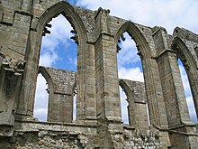
Part of the ruins at Bolton Abbey.


