North Island (Houtman-Abrolhos)
| North Island | ||
|---|---|---|
 | ||
| Gewässer | Indischer Ozean | |
| Inselgruppe | Wallabi-Inseln | |
| Geographische Lage | 28° 18′ 0″ S, 113° 35′ 45″ O | |
| Länge | 2 km | |
| Breite | 1,4 km | |
| Fläche | 1,824 km² | |
| Höchste Erhebung | Record Hill 13 m | |
| Einwohner | unbewohnt | |
 | ||

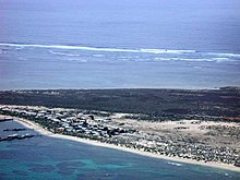
North Island ist eine kleine unbewohnte Insel im Indischen Ozean, gelegen etwa 75 km vor der westaustralischen Küste.
Sie wird überwiegend als die nördlichste Insel der Wallabi-Inseln angesehen, einer Inselgruppe im Norden des Houtman-Abrolhos-Archipels. Sie ist aber von den übrigen Wallabi-Inseln durch die South Passage getrennt, und liegt 18 km nordwestlich von West Wallabi Island und East Wallabi Island, den nächstgelegenen Inseln.
North Island ist die drittgrößte Insel der Wallabi-Inseln und gleichzeitig die drittgrößte im gesamten Houtman-Abrolhos-Archipel.
Siehe auch
- Liste der Inseln im Houtman-Abrolhos-Archipel
Weblinks
- weiteres NASA-Bild (Memento vom 23. Dezember 2010 im Internet Archive)
Auf dieser Seite verwendete Medien
Autor/Urheber: Tentotwo, Lizenz: CC BY-SA 3.0
Relief location map of Western Australia, Australia
Equidistant cylindrical projection, latitude of true scale 24.62° S (equivalent to equirectangular projection with N/S stretching 110 %). Geographic limits of the map:
- N: 13.2° S
- S: 35.5° S
- W: 112.5° E
- E: 129.5° E
This satellite image (Landsat 7) shows North Island in the north of Wallabi Group, Houtman Abrolhos, Western Australia
Autor/Urheber: Hesperian, Lizenz: CC BY-SA 4.0
This is a map of North Island in the Houtman Abrolhos off the coast of Western Australia. A small rock of the west coast of North Island, informally known as "Shag Rock", is also shown.
Areas shown in yellow are sparsely vegetated or unvegetated. Areas in green have reasonably dense vegetation.
Spatial information was traced from 1 metre resolution satellite imagery obtained using Google Earth, and can be assumed to be quite accurate. The huts in the southeast corner were also traced from satellite imagery, but identification of individual huts was problematic, and therefore probably inaccurate; these features should therefore be treated as indicative only of the spread and density of settlement.
Elevation features were not evident in satellite imagery so these have been placed in approximate position according to their position in a variety of sources, including the Gazetteer of Australia, the map Australia 1:100000 Topographic Survey Sheet 1641 (Edition 1): Wallabi, the digital topographic data (Version 2) of the Shuttle Radar Topography Mission (SRTM), and various other published maps, such as that on page 59 of Storr, G. M. (1960) "The physiography, vegetation and vertebrate Fauna of North Island", Journal of the Royal Society of Western Australia 43: 59–62.
Place names include both gazetted names, and informal names as used in publications such as Storr (1960) and Harvey, J. M., Alford, J. J., Longman, V. M. and Keighery, G. J. (2001) "A flora and vegetation survey of the Houtman Abrolhos, Western Australia", CALMScience 3(4):521–623.
Scale is accurate to about a metre per kilometre.Autor/Urheber: Boobook48 of Blogspot, Lizenz: CC BY-SA 3.0
This is an aerial photograph of North Island in the Houtman Abrolhos. The perspective is from the east of the island, looking west across the island's southern half.


