North Downs Way
| North Downs Way | |
|---|---|
Bei Hollingbourne, Maidstone, Kent | |
| Karte | |
 | |
| Daten | |
| Länge | 211 km |
| Lage | südöstliches England |
| Markierungszeichen | stilisierte aufrechte weiße Eichel auf braunem Grund |
| Startpunkt | Farnham 51° 13′ 0″ N, 0° 48′ 0″ W |
| Zielpunkt | Dover 51° 18′ 0″ N, 1° 19′ 0″ O |
| Typ | Fernwanderweg |
| Niedrigster Punkt | Dover, Meereshöhe |
| Schwierigkeitsgrad | leicht |
| Jahreszeit | ganzjährig |
| Besonderheiten | Folgt dem Kamm der Hügelkette der North Downs |
Der North Downs Way ist ein Fernwanderweg in Südengland von Farnham nach Dover, der im Jahr 1978 eröffnet wurde. Er verläuft vorbei an Godalming, Guildford, Dorking, Merstham, Otford und Rochester, entlang der Surrey Hills und Kent Downs, die beide als Area of Outstanding Natural Beauty (AONB) klassifiziert sind.
Östlich von Boughton Lees in der Nähe von Ashford, teilt sich der Weg in zwei Alternativen, der nördliche Weg verläuft über Canterbury und der südliche über Wye:
- Der südliche Abschnitt östlich von Boughton Lees kreuzt den Stour Valley Walk und führt an der Wye Crown vorbei.
- Der nördliche Abschnitt des Weges verläuft immer entlang der Bergrücken der North Downs Hügel auf dem steilen Teil des Stour-Tals im Westen und folgt in etwa dem Pilgrims' Way Path der im Mittelalter von vielen Pilgern genutzt wurde.
Die beiden Wegeabschnitte vereinigen sich dann wieder in Dover. Die nördliche Route ist 211 km lang, und die südliche Route 201 km, die Gesamtlänge der North Downs Way also 246 km.
Die Wegerechte sind gemischt, sie verändern sich im Verlauf vom Status als Fußweg, Reitweg, Nebenweg und Straße. Rund 19 % des Weges folgen Straßen, aber 75 % davon sind sehr kleine Wege.[1]
Der Weg führt durch das Downland, die Wege und die umliegende Landschaft sind durch Kreide-haltige Böden und Kalkmagerwiesen und -weiden sowie landwirtschaftlich genutzten Tonböden geprägt.
Fotografien
- (c) Ian Capper, CC BY-SA 2.0
Box Hill, Dorking mit Gedenkstätte für Leopold Salomon, der den Ort der Öffentlichkeit vermachte.
- (c) Richard Thomas, CC BY-SA 2.0
Newlands Corner, Guildford und der Fernwanderweg.
Einzelnachweise
Weblinks
Auf dieser Seite verwendete Medien
(c) Ian Capper, CC BY-SA 2.0
Salomons Memorial viewpoint at Box Hill, Surrey. Views over Dorking and Leith Hill.
(c) GkgAlf at the English Wikipedia, CC-BY-SA-3.0
Description: The North Downs Way near Hollinbourne
Author: Alfred Gay Source: Self Made
Date: 25th March 2007Autor/Urheber: Clem Rutter, Lizenz: GFDL
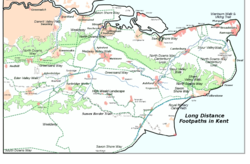
Adapted from User:ClemRutter who in 2007 produced a less detailed map of all the long distance footpaths in Kent in 2007 this 2012 has the Sussex Border Path and omits the London Circular and Vanguard paths for only a tiny % being in the Kent. Inspired by Jessop, Kent History Illustrated, with details from the KCC Public transport Map 2006/2007. There will be inaccuracies where paths join, or run parallel to a feature that was symbolic on the base map. Please inform me of serious errors and omissions via my Talk page. Constructed using Inkscape 0.45.1, so there may be rendering problems. Version 1 chose yellow for the path, it was great on the screen, but bad on the printer. I had used yellow because it follows the Yellow Arrow on the Waymarkers. This version uses dark green and changes the font so it is easier to read when rendered into a png. The Rivers are now blue. The spelling mistake in the name has been corrected.
Eichel-Symbol zur Routenführung der National Trails in Großbritanien
(c) Richard Thomas, CC BY-SA 2.0
North Downs Way at Newlands Corner. The footpath continues down the hill and into the next grid square at this Surrey Hills 'beauty spot.'


