Nikolov Cove
| Nikolov Cove | ||
|---|---|---|
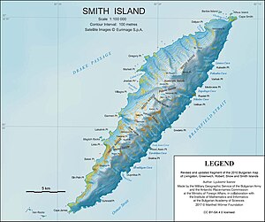
Karte von Smith Island mit der Nikolov Cove (Mitte rechts) | ||
| Gewässer | Bransfieldstraße | |
| Landmasse | Smith Island, Südliche Shetlandinseln | |
| Geographische Lage | 62° 58′ 0″ S, 62° 25′ 10″ W | |
| Breite | 950 m | |
| Tiefe | 500 m | |
| Zuflüsse | Owetsch-Gletscher | |
Die Nikolov Cove (englisch; bulgarisch Николов заливNikolow saliw) ist eine 0,95 km breite und 0,5 km lange Bucht an der Südostküste von Smith Island im Archipel der Südlichen Shetlandinseln. Sie liegt zwischen dem Velikan Point im Südwesten und dem Razdel Point im Nordosten.
Bulgarische Wissenschaftler kartierten sie 2009. Die bulgarische Kommission für Antarktische Geographische Namen benannte sie 2015 nach Todor Nikolow, einem Unterstützer der ersten bulgarischen Antarktisexpedition (1987–1988).
Weblinks
- Nikolov Cove im Composite Gazetteer of Antarctica (englisch)
Auf dieser Seite verwendete Medien
Autor/Urheber: Apcbg, Lizenz: CC BY-SA 4.0
L.L. Ivanov. Antarctica: Smith Island. Scale 1:100000 topographic map. Manfred Wörner Foundation, 2017. Revised and updated version of the first topographic map of Smith Island, fragment of the author’s 2010 map of Livingston Island and Greenwich, Robert, Snow and Smith Islands.
Autor/Urheber: NordNordWest, Lizenz: CC BY-SA 3.0
Positionskarte der Südlichen Shetlandinseln


