Nichtnavigatorischer Ortungsfunkdienst

Der nichtnavigatorische Ortungsfunkdienst (englisch radiolocation service) ist ein Funkdienst zum Zwecke der nichtnavigatorischen Funkortung.[1] Die an diesem Funkdienst beteiligten Funkstellen benutzen den Empfang von Funkwellen zur Bestimmung des Ortes eines Gegenstandes unter der Voraussetzung, dass dieser Funkwellen reflektiert oder aussendet.
Dem nichtnavigatorischen Ortungsfunkdienst dienen u. a. militärisch genutzte Radarsensoren, vorwiegend an Land, aber auch in Satelliten, Schiffen oder Flugkörpern, ebenso Feuerleitradarsensoren, Waffenleitradare, Funkmessvisiere (kurz: FMV) und Radarzielbeleuchter.
Die VO Funk[2] definiert diesen Funkdienst wie folgt:
- Ortungsfunkdienst (Artikel 1.40)
- Nichtnavigatorischer Ortungsfunkdienst (Artikel 1.48)
- Nichtnavigatorischer Ortungsfunkdienst über Satelliten (Artikel 1.49)
Der nichtnavigatorische Ortungsfunkdienst unterscheidet grundsätzlich folgende Funkstellen:
- Mobile nichtnavigatorische Ortungsfunkstelle (MobNNavOFust)
- Ortsfeste nichtnavigatorische Ortungsfunkstelle (OfNNavOFust)
 OfNNavOFuSt (Parabolantenne)
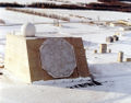 OfNNavOFuSt (Active Phased Array Radar)
 (c) Bundesarchiv, Bild 101I-356-1845-08 / Müller / CC-BY-SA 3.0OfNNavOFuSt (Feuerleitradar FuMG 39 „Würzburg“)
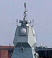 MobNNavOFuSt (Fregatte Hamburg)
 MobNNavOFuSt (Boeing E-3)
 FMV der MiG-23 (Sapfir-23), Rückansicht.

Einzelnachweise
- ↑ World Radiocommunication Conference, 9. Juni – 4. Juli 2003, Genf, Final Acts.
- ↑ Radio Regulations, Edition of 2012
Ortungsfunkdienst … Ortungsfunkdienst über Satelliten
Navigationsfunkdienst … Navigationsfunkdienst über Satelliten | Flugnavigationsfunkdienst | Flugnavigationsfunkdienst über Satelliten | Seenavigationsfunkdienst | Seenavigationsfunkdienst über Satelliten
Nichtnavigatorischer Ortungsfunkdienst … Nichtnavigatorischer Ortungsfunkdienst über Satelliten
Auf dieser Seite verwendete Medien

Autor/Urheber: User:VargaA, Lizenz: CC BY-SA 4.0
Rear view of RP-23 Sapfir-23 radar (used on MiG-23), displayed at the Hungarian Aviation Museum, Szolnok

Autor/Urheber: USN, Lizenz: CC BY-SA 3.0
The Thales Nederland Active Phased Array Radar (APAR), mounted on the German Sachsen class frigate Hamburg (F 220); ITU-classificatio: Radiolocation land station in the radiolocation service.
(c) Averse, CC BY-SA 3.0
Großer Arber mit den beiden Radarkuppeln des Abgesetzten Technischen Zuges 358 (Einsatzführungsdienst der Luftwaffe). Die rechte Kuppel beherbergt einen Sensor vom Typ RRP 117, währen die linke Kuppel außer Dienst gestellt wurde und derzeit leer steht.

The E-3 Sentry is an airborne warning and control system aircraft that provides all-weather surveillance, command, control and communications needed by commanders of U.S. and NATO air defense forces. As proven in Desert Storm, it is the premier air battle command and control aircraft in the world today. The E-3 Sentry is a modified Boeing 707/320 commercial airframe with a rotating radar dome. The dome is 30 feet in diameter, six feet thick, and is held 11 feet above the fuselage by two struts. It contains a radar subsystem that permits surveillance fromthe Earth's surface up into the stratosphere, over land or water. The radar has a range of more than 200 miles for low-flying targets and farther for aerospace vehicles flying at medium to high altitudes. The radar combined with an identification friend or foe subsystem can look down to detect, identify and track enemy and friendly low-flying aircraft by eliminating ground clutter returns that confuse other radar systems.

(c) Bundesarchiv, Bild 101I-356-1845-08 / Müller / CC-BY-SA 3.0

This RADAR is the ARPA Long-Range Tracking And Instrumentation Radar (ALTAIR) located in the Kwajalein atoll on the island of Roi-Namur in the Ronald Reagan Ballistic Missile Defense Test Site. It was initially developed and built between 1968 and 1970.
ITU-classificatio: Radiolocation land station in the radiolocation service. For full specifications see:

Autor/Urheber:
Vector version of Strahlung.png, used on German wikipedia.