Nationalpark Mount Kenya
Nationalpark Mount Kenya | ||
 | ||
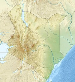
| Lage | Ostafrika | |
| Fläche | 2.023,34 km² | |
| WDPA-ID | 757 | |
| Geographische Lage | 0° 9′ S, 37° 19′ O | |
| Einrichtungsdatum | 1997 | |
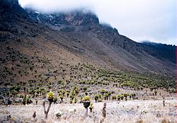
Der Nationalpark Mount Kenya ist ein Schutzgebiet in Kenia. Es wurde 1949 ausgewiesen,[1] um Flora und Fauna rund um das Mount-Kenya-Massiv zu schützen.[2] Die höchsten Gipfel dieser Berge sind über das ganze Jahr mit Schnee bedeckt.[3] Durch die Einrichtung des Parks will die kenianische Regierung die Wasserversorgung in der Region sicherstellen.[4]
Einzelnachweise
- ↑ https://www.worldatlas.com/mountains/mount-kenya.html Mount Kenya
- ↑ Mount Kenya National Park/Natural Forest. UNESCO, abgerufen am 29. September 2016 (englisch).
- ↑ Africa bears the brunt of climate change. In: WWF. 17. März 2008, abgerufen am 29. September 2016 (englisch).
- ↑ Gichuki, Francis Ndegwa: Threats and Opportunities for Mountain Area Development in Kenya. In: Ambio. Vol. 28, Nr. 5. Royal Swedish Academy of Sciences, August 1999, S. 430–435 (englisch).
Auf dieser Seite verwendete Medien
Autor/Urheber: Uwe Dedering, Lizenz: CC BY-SA 3.0
Location map of Kenya
Equirectangular projection. Strechted by 100.0%. Geographic limits of the map:
- N: 6.0° N
- S: -5.0° N
- W: 33.0° E
- E: 43.0° E
Autor/Urheber: User:Doron, Lizenz: CC BY-SA 3.0
Giant groundsel flowers (Senecio keniodendron) in Mackinder Valley, Mount Kenya, Kenya. The flat foreground is due to valley train deposits from sediment rich glacial rivers filling up the valley.


