National Register of Historic Places in South Dakota

Karte der Countys von South Dakota und Verteilung der NRHP-Einträge

Diese Tabelle enthält alle Listen, in denen die Einträge im National Register of Historic Places in den 66 Countys des US-amerikanischen Bundesstaates South Dakota aufgeführt sind[1]:

Anzahl der Objekte und Distrikte nach County

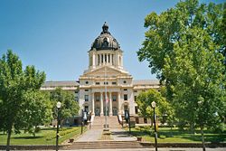
Das South Dakota State Capitol in Pierre, seit 1976 im NRHP gelistet[2]
(c) Thomas Wolf, www.foto-tw.de, CC BY-SA 3.0
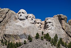
Das Mount Rushmore National Memorial in den Black Hills, seit 1966 im NRHP gelistet[3]
Das Old Minnehaha County Courthouse in Sioux Falls, seit 1973 im NRHP gelistet[4]
CountyListe der Einträge in das NRHP im CountyAnzahl
1AuroraNRHP-Einträge im Aurora County9
2BeadleNRHP-Einträge im Beadle County25
3BennettNRHP-Einträge im Bennett County0
4Bon HommeNRHP-Einträge im Bon Homme County39
5BrookingsNRHP-Einträge im Brookings County38
6BrownNRHP-Einträge im Brown County44
7BruleNRHP-Einträge im Brule County4
8BuffaloNRHP-Einträge im Buffalo County6
9ButteNRHP-Einträge im Butte County35
10CampbellNRHP-Einträge im Campbell County2
11Charles MixNRHP-Einträge im Charles Mix County13
12ClarkNRHP-Einträge im Clark County9
13ClayNRHP-Einträge im Clay County38
14CodingtonNRHP-Einträge im Codington County43
15CorsonNRHP-Einträge im Corson County8
16CusterNRHP-Einträge im Custer County46
17DavisonNRHP-Einträge im Davison County23
18DayNRHP-Einträge im Day County10
19DeuelNRHP-Einträge im Deuel County10
20DeweyNRHP-Einträge im Dewey County5
21DouglasNRHP-Einträge im Douglas County8
22EdmundsNRHP-Einträge im Edmunds County12
23Fall RiverNRHP-Einträge im Fall River County72
24FaulkNRHP-Einträge im Faulk County8
25GrantNRHP-Einträge im Grant County15
26GregoryNRHP-Einträge im Gregory County10
27HaakonNRHP-Einträge im Haakon County2
28HamlinNRHP-Einträge im Hamlin County14
29HandNRHP-Einträge im Hand County6
30HansonNRHP-Einträge im Hanson County6
31HardingNRHP-Einträge im Harding County56
32HughesNRHP-Einträge im Hughes County41
33HutchinsonNRHP-Einträge im Hutchinson County29
34HydeNRHP-Einträge im Hyde County3
35JacksonNRHP-Einträge im Jackson County8
36JerauldNRHP-Einträge im Jerauld County13
37JonesNRHP-Einträge im Jones County4
38KingsburyNRHP-Einträge im Kingsbury County20
39LakeNRHP-Einträge im Lake County15
40LawrenceNRHP-Einträge im Lawrence County51
41LincolnNRHP-Einträge im Lincoln County23
42LymanNRHP-Einträge im Lyman County8
43MarshallNRHP-Einträge im Marshall County6
44McCookNRHP-Einträge im McCook County8
45McPhersonNRHP-Einträge im McPherson County4
46MeadeNRHP-Einträge im Meade County27
47MelletteNRHP-Einträge im Mellette County2
48MinerNRHP-Einträge im Miner County3
49MinnehahaNRHP-Einträge im Minnehaha County98
50MoodyNRHP-Einträge im Moody County14
51Oglala LakotaNRHP-Einträge im Shannon County1
52PenningtonNRHP-Einträge im Pennington County57
53PerkinsNRHP-Einträge im Perkins County18
54PotterNRHP-Einträge im Potter County8
55RobertsNRHP-Einträge im Roberts County10
56SanbornNRHP-Einträge im Sanborn County8
57SpinkNRHP-Einträge im Spink County25
58StanleyNRHP-Einträge im Stanley County12
59SullyNRHP-Einträge im Sully County4
60ToddNRHP-Einträge im Todd County4
61TrippNRHP-Einträge im Tripp County6
62TurnerNRHP-Einträge im Turner County30
63UnionNRHP-Einträge im Union County14
64WalworthNRHP-Einträge im Walworth County13
65YanktonNRHP-Einträge im Yankton County79
66ZiebachNRHP-Einträge im Ziebach County1
Summe...1
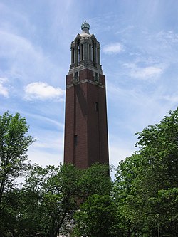
Coughlin Campanile in Brookings, seit 1987 im NRHP gelistet[5]
Das Zentrum von Deadwood, seit 1966 im NRHP gelistet[6]
Historischer Dell Rapids Watertower im Minnehaha County[7]
Wounded Knee im Oglala Lakota County, Eingangstor zum Friedhof; am Platz, wo mit Kanonen das Massker an den Sioux begangen wurde, und später ein Massengrab entstand[8]

Siehe auch

Einzelnachweise

  1. National Register of Historic Places Abgerufen am 8. Juli 2013
  2. Auszug aus dem National Register of Historic Places - Nr. 76001737 Abgerufen am 8. Juli 2013
  3. Auszug aus dem National Register of Historic Places - Nr. 66000718 Abgerufen am 8. Juli 2013
  4. Auszug aus dem National Register of Historic Places - Nr. 73001749 Abgerufen am 8. Juli 2013
  5. Auszug aus dem National Register of Historic Places - Nr. 87000223 Abgerufen am 8. Juli 2013
  6. Auszug aus dem National Register of Historic Places - Nr. 66000716 Abgerufen am 8. Juli 2013
  7. Auszug aus dem National Register of Historic Places - Nr. 84003356 Abgerufen am 8. Dezember 2017
  8. Auszug aus dem National Register of Historic Places - Nr. 66000719 Abgerufen am 8. Dezember 2017

Weblinks

Commons: National Register of Historic Places in South Dakota – Sammlung von Bildern, Videos und Audiodateien

Auf dieser Seite verwendete Medien

Deadwood today.jpg
Autor/Urheber: Der ursprünglich hochladende Benutzer war Gorilla Jones in der Wikipedia auf Englisch, Lizenz: CC BY-SA 3.0
Deadwood today (view from Mount Moriah). (Photo taken and uploaded by the author.) Photo sharpened, cropped, and color, levels, and contrast corrected by Schcambo.
OldMinnehahaCountyCH9.jpg
Autor/Urheber: AlexiusHoratius, Lizenz: CC BY-SA 3.0
Old Minnehaha County Courthouse in Sioux Falls, South Dakota, USA. Currently a museum.
NRHP South Dakota Map.svg
Autor/Urheber: 25or6to4, Lizenz: CC BY-SA 3.0
Map of South Dakota NRHP/100 sq. mi., by county. As of 1/8/10
Wounded Knee 96.jpg
Autor/Urheber: Napa, Lizenz: CC BY 2.5
Wounded Knee, Pine Ridge Reservation, South Dakota, USA. Entrance gate to cemetery, location of Hotchkiss gun used during Wounded Knee Massacre and later mass grave for victims.
Pierre capitol1.jpg
(c) Dk4hb, CC BY-SA 3.0

Das Capitol in Pierre South Dakota, eigenes Foto aufgenommen im Juni 2004

Fotograf R.Blauert
Dell Rapids watertower 1.jpg
Autor/Urheber: AlexiusHoratius, Lizenz: CC BY-SA 3.0
Historic Dell Rapids Watertower in Dell Rapids, South Dakota, USA.
Coughlin Campanile 1.jpg
(c) Shatner aus der englischsprachigen Wikipedia, CC BY-SA 3.0
Image of the Coughlin Campanile taken by Andrew Boerema - 2005