National Register of Historic Places in Illinois
Diese Tabelle enthält alle Listen, in denen die Einträge im National Register of Historic Places in den 102 Countys des US-amerikanischen Bundesstaates Illinois aufgeführt sind.[1]
Anzahl der Objekte und Distrikte nach County
Siehe auch
Einzelnachweise
- ↑ National Register of Historic Places Abgerufen am 4. September 2012
- ↑ Auszug aus dem National Register of Historic Places – Nr. 85003178 Abgerufen am 4. September 2012
- ↑ Auszug aus dem National Register of Historic Places – Nr. 66000330 Abgerufen am 4. September 2012
- ↑ Auszug aus dem National Register of Historic Places – Nr. 75000644 Abgerufen am 4. September 2012
- ↑ Auszug aus dem National Register of Historic Places – Nr. 84000986 Abgerufen am 4. September 2012
- ↑ Auszug aus dem National Register of Historic Places – Nr. 66000946 Abgerufen am 4. September 2012
- ↑ Auszug aus dem National Register of Historic Places – Nr. 73000715 Abgerufen am 4. September 2012
- ↑ Auszug aus dem National Register of Historic Places – Nr. 71000293 Abgerufen am 4. September 2012
- ↑ Auszug aus dem National Register of Historic Places – Nr. 04000175 Abgerufen am 4. September 2012
- ↑ Auszug aus dem National Register of Historic Places – Nr. 66000899 Abgerufen am 4. September 2012
Weblinks
Auf dieser Seite verwendete Medien
Autor/Urheber: Kbh3rd, Lizenz: CC BY-SA 3.0
This is a panoramic image of the Eads Bridge and Martin Luther King Bridge which span the Mississippi River at St. Louis, Missouri. This is a composite of four images taken with a Kodak P850 digital camera that were stitched with the hugin panorama tool.
(c) Afries52 in der Wikipedia auf Englisch, CC BY 3.0
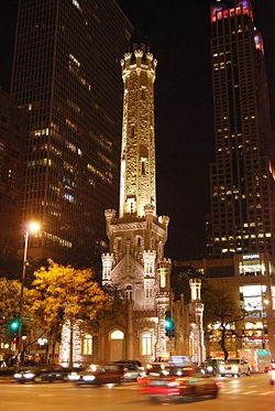
Chicago Water Tower at Night
Autor/Urheber: 25or6to4, Lizenz: CC BY-SA 3.0
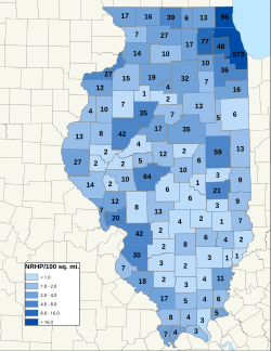
Map of Illinos NRHP/100 sq. mi., by county. As of 12/11/09
(c) Skubasteve834 aus der englischsprachigen Wikipedia, CC-BY-SA-3.0
I took this picture on the very top of en:Monk's Mound, which is 100 ft tall.. [1] You can see other small mounds in the distance.
Fort Massac Site on NRHP since July 14, 1971. Located SE of Metropolis, Illinois on the Ohio River. Photo shows reconstruction of the fort, with the Ohio River and a statue to George Rodgers Clark in the background
Autor/Urheber: Daniel Schwen, Lizenz: CC BY-SA 4.0
Capitol des US Bundesstaats Illinois in Springfield
Aerial view of Lock and Dam No. 15 on the Mississippi River between Rock Island, Illinois and Davenport, Iowa. View is from the Illinois side of the river looking northwest to Iowa. The Government Bridge, a combined auto and railroad bridge, spans the river right over the locks, necessitating a turntable drawbridge to clear the locks. Rock Island District Office is also located here.
Location: Rock Island, Illinois, 41°31′07″N 90°34′08″W / 41.51861°N 90.56889°W


