National City
| National City | |
|---|---|
(c) Roman Eugeniusz, CC BY-SA 3.0 | |
 |  |
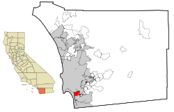
| Lage in Kalifornien und im County | |
| Basisdaten | |
| Gründung: | 7. Juli 1868 |
| Staat: | Vereinigte Staaten |
| Bundesstaat: | Kalifornien |
| County: | San Diego County |
| Koordinaten: | 32° 41′ N, 117° 6′ W |
| Zeitzone: | Pacific (UTC−8/−7) |
| Einwohner: – Metropolregion: | 56.173 (Stand: 2020) 4.922.723 (Stand: 2007) |
| Haushalte: | 17.169 (Stand: 2020) |
| Fläche: | 23,9 km2 (ca. 9 mi²) davon 19,1 km2 (ca. 7 mi²) Land |
| Bevölkerungsdichte: | 2.941 Einwohner je km2 |
| Höhe: | 21 m |
| Postleitzahl: | 91950 |
| Vorwahl: | +1 619 |
| FIPS: | 06-50398 |
| GNIS-ID: | 1661090 |
| Website: | www.nationalcityca.gov |
| Bürgermeister: | Alejandra Sotelo-Solis |
National City ist eine Stadt im San Diego County im US-Bundesstaat Kalifornien der Vereinigten Staaten.
Das U.S. Census Bureau hat bei der Volkszählung 2020 eine Einwohnerzahl von 56.173 ermittelt.[1]
Das Stadtgebiet hat eine Größe von 23,9 km² und befindet sich an den Interstates 5 und 805 sowie der California State Route 54.
Persönlichkeiten
Töchter und Söhne der Stadt:
- Raphael Robinson (1911–1995), mathematischer Logiker und Mathematiker
- John Baldessari (1931–2020), Konzeptkünstler
- Juan C. Vargas (* 1961), Politiker
- Andrew Phillip Cunanan (1969–1997), Mörder von Gianni Versace
Weblinks
Einzelnachweise
- ↑ Explore Census Data National City city, California. Abgerufen am 23. Dezember 2022.
Auf dieser Seite verwendete Medien
This is a locator map showing San Diego County in California. For more information, see Commons:United States county locator maps.
Autor/Urheber: Arkyan, Lizenz: CC BY-SA 3.0
This map shows the incorporated and unincorporated areas in San Diego County, California, highlighting National City in red. It was created with a custom script with US Census Bureau data and modified with Inkscape.
(c) Roman Eugeniusz, CC BY-SA 3.0
National City,California,usa.


