Nagaur
| Nagaur | ||
|---|---|---|
| Staat: | ||
| Bundesstaat: | Rajasthan | |
| Distrikt: | Nagaur | |
| Subdistrikt: | Nagaur | |
| Lage: | 27° 12′ N, 73° 44′ O | |
| Höhe: | 295 m | |
| Einwohner: | 102.872 (2011)[1] | |
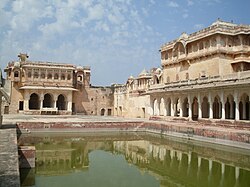
| Festung von Nagaur | ||
Nagaur ist eine Stadt im indischen Bundesstaat Rajasthan.
Nagaur ist Verwaltungszentrum des gleichnamigen Distrikts. Die Stadt liegt 200 km westlich von Jaipur. Die nationalen Fernstraßen NH 65 (Jodhpur–Hisar) und NH 89 (Bikaner–Ajmer) kreuzen sich in Nagaur. Beim Zensus 2011 betrug die Einwohnerzahl 102.872. In Nagaur befindet sich eine alte Festung aus dem frühen 12. Jahrhundert.
Weblinks
Einzelnachweise
Auf dieser Seite verwendete Medien
Autor/Urheber: AshwiniKalantri, Lizenz: CC BY-SA 3.0
Location map of India with Indian claimed territories in grey. Equirectangular projection. Strechted by 106.0%. Geographic limits of the map: * N: 37.5° N * S: 5.0° N * W: 67.0° E * E: 99.0° E Made with Natural Earth. Free vector and raster map data @ naturalearthdata.com.
Autor/Urheber: Rituraj.bharti, Lizenz: CC BY-SA 3.0
Nagaur (Nāgaur) is a city in the state of Rajasthan in India. It is the administrative headquarters of Nagaur District. The Nagaur city lies about midway between Jodhpur and Bikaner. It was founded by the Naga Kshatriyas.


