NUTS:UK
Als NUTS:UK oder NUTS-Regionen in dem Vereinigten Königreich bezeichnet man die territoriale Gliederung des Vereinigten Königreichs gemäß der europäischen „Systematik der Gebietseinheiten für die Statistik“ (NUTS).
Grundlagen
Im Vereinigten Königreich werden die drei NUTS-Ebenen wie folgt belegt:
- NUTS-1: Regionen
- NUTS-2: Grafschaften
- NUTS-3: Districts und Boroughs
NUTS-Codes
| NUTS 1 | Code | NUTS 2 | Code | NUTS 3 | Code |
|---|---|---|---|---|---|
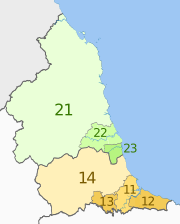
| North East, England | UKC | Tees Valley and Durham | UKC1 | Hartlepool and Stockton-on-Tees | UKC11 |
Dr Greg and Nilfanion. Contains Ordnance Survey data © Crown copyright and database right 2011, CC BY-SA 3.0 | South Teesside (Middlesbrough and Redcar and Cleveland) | UKC12 | |||
| Darlington | UKC13 | ||||
| County Durham | UKC14 | ||||
| Northumberland and Tyne and Wear | UKC2 | Northumberland | UKC21 | ||
| Tyne and Wear (Newcastle upon Tyne, Gateshead, South Tyneside, North Tyneside) | UKC22 | ||||
| Sunderland | UKC23 | ||||
| North West, England | UKD | Cumbria | UKD1 | West Cumbria (Allerdale, Barrow-in-Furness, Copeland) | UKD11 |
Dr Greg and Nilfanion. Contains Ordnance Survey data © Crown copyright and database right 2011, CC BY-SA 3.0 | East Cumbria (Carlisle, Eden, South Lakeland) | UKD12 | |||
| Cheshire | UKD6 | Warrington | UKD61 | ||
| Cheshire East | UKD62 | ||||
| Cheshire West and Chester | UKD63 | ||||
| Greater Manchester | UKD3 | Greater Manchester South (Manchester, Salford, Stockport, Tameside, Trafford) | UKD31 | ||
| Greater Manchester North (Bolton, Bury, Oldham, Rochdale, Wigan) | UKD32 | ||||
| Lancashire | UKD4 | Blackburn with Darwen | UKD41 | ||
| Blackpool | UKD42 | ||||
| Lancashire CC | UKD43 | ||||
| Merseyside | UKD7 | East Merseyside (Knowsley, St Helens and Halton) | UKD71 | ||
| Liverpool | UKD72 | ||||
| Sefton | UKD73 | ||||
| Wirral | UKD74 | ||||
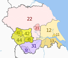
| Yorkshire and the Humber, England | UKE | East Riding and North Lincolnshire | UKE1 | Kingston upon Hull | UKE11 |
Dr Greg and Nilfanion. Contains Ordnance Survey data © Crown copyright and database right 2011, CC BY-SA 3.0 | East Riding of Yorkshire | UKE12 | |||
| North and North East Lincolnshire | UKE13 | ||||
| North Yorkshire | UKE2 | York | UKE21 | ||
| North Yorkshire CC | UKE22 | ||||
| South Yorkshire | UKE3 | Barnsley, Doncaster and Rotherham | UKE31 | ||
| Sheffield | UKE32 | ||||
| West Yorkshire | UKE4 | Bradford | UKE41 | ||
| Leeds | UKE42 | ||||
| Calderdale and Kirklees | UKE44 | ||||
| Wakefield | UKE45 | ||||
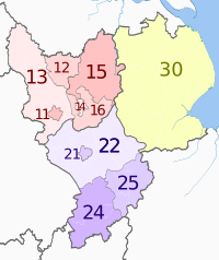
| East Midlands, England | UKF | Derbyshire and Nottinghamshire | UKF1 | Derby | UKF11 |
Dr Greg and Nilfanion. Contains Ordnance Survey data © Crown copyright and database right 2011, CC BY-SA 3.0 | East Derbyshire (Bolsover, Chesterfield, North East Derbyshire) | UKF12 | |||
| South and West Derbyshire (Amber Valley, Derbyshire Dales, Erewash, High Peak, South Derbyshire) | UKF13 | ||||
| Nottingham | UKF14 | ||||
| North Nottinghamshire (Ashfield, Bassetlaw, Mansfield, Newark and Sherwood) | UKF15 | ||||
| South Nottinghamshire (Broxtowe, Gedling, Rushcliffe) | UKF16 | ||||
| Leicestershire, Rutland and Northamptonshire | UKF2 | Leicester | UKF21 | ||
| Leicestershire CC and Rutland | UKF22 | ||||
| West Northamptonshire (Northampton, Daventry and South Northamptonshire) | UKF24 | ||||
| North Northamptonshire (East Northamptonshire, Corby, Wellingborough and Kettering) | UKF25 | ||||
| Lincolnshire | UKF3 | Lincolnshire CC | UKF30 | ||
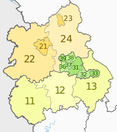
| West Midlands, England | UKG | Herefordshire, Worcestershire and Warwickshire | UKG1 | Herefordshire | UKG11 |
Dr Greg and Nilfanion. Contains Ordnance Survey data © Crown copyright and database right 2011, CC BY-SA 3.0 | Worcestershire CC | UKG12 | |||
| Warwickshire CC | UKG13 | ||||
| Shropshire and Staffordshire | UKG2 | Telford and Wrekin | UKG21 | ||
| Shropshire CC | UKG22 | ||||
| Stoke-on-Trent | UKG23 | ||||
| Staffordshire CC | UKG24 | ||||
| West Midlands | UKG3 | Birmingham | UKG31 | ||
| Solihull | UKG32 | ||||
| Coventry | UKG33 | ||||
| Dudley | UKG36 | ||||
| Sandwell | UKG37 | ||||
| Walsall | UKG38 | ||||
| Wolverhampton | UKG39 | ||||
| East of England | UKH | East Anglia | UKH1 | Peterborough | UKH11 |
Dr Greg and Nilfanion. Contains Ordnance Survey data © Crown copyright and database right 2011, CC BY-SA 3.0 | Cambridgeshire CC | UKH12 | |||
| Norfolk | UKH13 | ||||
| Suffolk | UKH14 | ||||
| Bedfordshire and Hertfordshire | UKH2 | Luton | UKH21 | ||
| Bedford | UKH24 | ||||
| Central Bedfordshire | UKH25 | ||||
| Hertfordshire CC | UKH23 | ||||
| Essex | UKH3 | Southend-on-Sea | UKH31 | ||
| Thurrock | UKH32 | ||||
| Essex CC | UKH33 | ||||
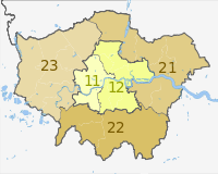
| London, England | UKI | Inner London | UKI1 | West Inner London (City of London, Camden, Hammersmith and Fulham, Kensington and Chelsea, Wandsworth, City of Westminster) | UKI11 |
Dr Greg and Nilfanion. Contains Ordnance Survey data © Crown copyright and database right 2010, CC BY-SA 3.0 | East Inner London (Hackney, Haringey, Islington, Lambeth, Lewisham, Newham, Southwark, Tower Hamlets) | UKI12 | |||
| Outer London | UKI2 | East and North East Outer London (Barking and Dagenham, Bexley, Enfield, Greenwich, Havering, Redbridge, Waltham Forest) | UKI21 | ||
| South Outer London (Bromley, Croydon, Kingston upon Thames, Merton, Sutton) | UKI22 | ||||
| West and North West Outer London (Barnet, Brent, Ealing, Harrow, Hillingdon, Hounslow, Richmond upon Thames) | UKI23 | ||||
| South East, England | UKJ | Berkshire, Buckinghamshire, and Oxfordshire | UKJ1 | Berkshire | UKJ11 |
Dr Greg and Nilfanion. Contains Ordnance Survey data © Crown copyright and database right 2011, CC BY-SA 3.0 | Milton Keynes | UKJ12 | |||
| Buckinghamshire CC | UKJ13 | ||||
| Oxfordshire | UKJ14 | ||||
| Surrey, East and West Sussex | UKJ2 | Brighton and Hove | UKJ21 | ||
| East Sussex CC | UKJ22 | ||||
| Surrey | UKJ23 | ||||
| West Sussex CC | UKJ24 | ||||
| Hampshire and Isle of Wight | UKJ3 | Portsmouth | UKJ31 | ||
| Southampton | UKJ32 | ||||
| Hampshire CC | UKJ33 | ||||
| Isle of Wight | UKJ34 | ||||
| Kent | UKJ4 | Medway | UKJ41 | ||
| Kent CC | UKJ42 | ||||
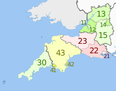
| South West, England | UKK | Gloucestershire, Wiltshire and Bristol/Bath area | UKK1 | Bristol | UKK11 |
Dr Greg and Nilfanion. Contains Ordnance Survey data © Crown copyright and database right 2011, CC BY-SA 3.0 | Bath and North East Somerset, North Somerset and South Gloucestershire | UKK12 | |||
| Gloucestershire CC | UKK13 | ||||
| Swindon | UKK14 | ||||
| Wiltshire | UKK15 | ||||
| Dorset and Somerset | UKK2 | Bournemouth and Poole | UKK21 | ||
| Dorset CC | UKK22 | ||||
| Somerset | UKK23 | ||||
| Cornwall and Isles of Scilly | UKK3 | Cornwall and Isles of Scilly | UKK30 | ||
| Devon | UKK4 | Plymouth | UKK41 | ||
| Torbay | UKK42 | ||||
| Devon CC | UKK43 | ||||
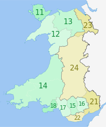
| Wales | UKL | West Wales and The Valleys | UKL1 | Isle of Anglesey | UKL11 |
(c) Dr Greg and NordNordWest, CC BY-SA 3.0 | Gwynedd | UKL12 | |||
| Conwy and Denbighshire | UKL13 | ||||
| South West Wales (Ceredigion, Carmarthenshire, Pembrokeshire) | UKL14 | ||||
| Central Valleys (Merthyr Tydfil, Rhondda Cynon Taf) | UKL15 | ||||
| Gwent Valleys (Blaenau Gwent, Caerphilly, Torfaen) | UKL16 | ||||
| Bridgend and Neath Port Talbot | UKL17 | ||||
| Swansea | UKL18 | ||||
| East Wales | UKL2 | Monmouthshire and Newport | UKL21 | ||
| Cardiff and Vale of Glamorgan | UKL22 | ||||
| Flintshire and Wrexham | UKL23 | ||||
| Powys | UKL24 | ||||
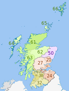
| Scotland | UKM | Eastern Scotland | UKM2 | Angus and Dundee | UKM21 |
Dr Greg, Nilfanion & XrysD. Contains Ordnance Survey data © Crown copyright and database right 2011, CC BY-SA 3.0 Dr Greg, Nilfanion & XrysD. Contains Ordnance Survey data © Crown copyright and database right 2011, CC BY-SA 3.0 | Clackmannanshire and Fife | UKM22 | |||
| East Lothian and Midlothian | UKM23 | ||||
| Scottish Borders | UKM24 | ||||
| Edinburgh | UKM25 | ||||
| Falkirk | UKM26 | ||||
| Perth and Kinross, and Stirling | UKM27 | ||||
| West Lothian | UKM28 | ||||
| South Western Scotland | UKM3 | East Dunbartonshire, West Dunbartonshire, and Helensburgh and Lomond | UKM31 | ||
| Dumfries and Galloway | UKM32 | ||||
| East and North Ayrshire mainland | UKM33 | ||||
| Glasgow | UKM34 | ||||
| Inverclyde, East Renfrewshire, and Renfrewshire | UKM35 | ||||
| North Lanarkshire | UKM36 | ||||
| South Ayrshire | UKM37 | ||||
| South Lanarkshire | UKM38 | ||||
| North Eastern Scotland | UKM5 | Aberdeen and Aberdeenshire | UKM50 | ||
| Highlands and Islands | UKM6 | Caithness and Sutherland, and Ross and Cromarty | UKM61 | ||
| Inverness, Nairn, Moray, and Badenoch and Strathspey | UKM62 | ||||
| Lochaber, Skye and Lochalsh, Arran and Cumbrae, and Argyll and Bute (except Helensburgh and Lomond) | UKM63 | ||||
| Eilean Siar (Western Isles) | UKM64 | ||||
| Orkney Islands | UKM65 | ||||
| Shetland Islands | UKM66 | ||||
| Northern Ireland | UKN | Northern Ireland | UKN0 | Belfast | UKN01 |
(c) Dr Greg and NordNordWest, CC BY-SA 3.0 | Outer Belfast (Carrickfergus, Castlereagh, Lisburn, Newtownabbey, North Down) | UKN02 | |||
| East of Northern Ireland (Antrim, Ards, Ballymena, Banbridge, Craigavon, Down, Larne) | UKN03 | ||||
| North of Northern Ireland (Ballymoney, Coleraine, Derry, Limavady, Moyle, Strabane) | UKN04 | ||||
| West and South of Northern Ireland (Armagh, Cookstown, Dungannon, Fermanagh, Magherafelt, Newry and Mourne, Omagh) | UKN05 | ||||
Weblinks
- Correspondence between the NUTS levels and the national administrative units
- List of current NUTS codes
- Overview map of EU Countries – NUTS level 1
- Eurostat Introduction to NUTS classification
- National Statistics Introduction to NUTS- dead link
- Divisions of the United Kingdom, Statoids.com
- Listings of subdivisions of NUTS / LAU areas, Office for National Statistics, accessed 6 September 2012
- Metadata Download NUTS (Nomenclature of Territorial Units for Statistics), by regional level (NUTS) accessed 11 June 2012
Auf dieser Seite verwendete Medien
Die Europaflagge besteht aus einem Kranz aus zwölf goldenen, fünfzackigen, sich nicht berührenden Sternen auf azurblauem Hintergrund.
Sie wurde 1955 vom Europarat als dessen Flagge eingeführt und erst 1986 von der Europäischen Gemeinschaft übernommen.
Die Zahl der Sterne, zwölf, ist traditionell das Symbol der Vollkommenheit, Vollständigkeit und Einheit. Nur rein zufällig stimmte sie zwischen der Adoption der Flagge durch die EG 1986 bis zur Erweiterung 1995 mit der Zahl der Mitgliedstaaten der EG überein und blieb daher auch danach unverändert.Autor/Urheber: own, Lizenz: CC BY-SA 2.5
Karte der NUTS 1 Regionen der Europäische Union, 2007
Dr Greg and Nilfanion. Contains Ordnance Survey data © Crown copyright and database right 2010, CC BY-SA 3.0
Map of the NUTS 3 regions of London.
Equirectangular map projection on WGS 84 datum, with N/S stretched 160% Geographic limits:
- West: 0.57W
- East: 0.37E
- North: 51.72N
- South: 51.25N
Dr Greg and Nilfanion. Contains Ordnance Survey data © Crown copyright and database right 2011, CC BY-SA 3.0
Map of the NUTS 3 regions of the East of England, from 2010.
Equirectangular map projection on WGS 84 datum, with N/S stretched 160%
Geographic limits:
- West: 0.8W
- East: 1.8E
- North: 53.1N
- South: 51.4N
Dr Greg and Nilfanion. Contains Ordnance Survey data © Crown copyright and database right 2011, CC BY-SA 3.0
Map of the NUTS 3 regions of the East Midlands of England, from 2010.
Equirectangular map projection on WGS 84 datum, with N/S stretched 165%
Geographic limits:
- West: 2.1W
- East: 0.4E
- North: 53.7N
- South: 51.9N
Dr Greg and Nilfanion. Contains Ordnance Survey data © Crown copyright and database right 2011, CC BY-SA 3.0
Map of the NUTS 3 regions of Yorkshire and the Humber in England, from 2010.
Equirectangular map projection on WGS 84 datum, with N/S stretched 170%
Geographic limits:
- West: 2.65W
- East: 0.25E
- North: 54.65N
- South: 53.2N
Dr Greg and Nilfanion. Contains Ordnance Survey data © Crown copyright and database right 2011, CC BY-SA 3.0
Map of the NUTS 3 regions of South West England.
Equirectangular map projection on WGS 84 datum, with N/S stretched 160%
Geographic limits:
- West: 6.5W
- East: 1.4W
- North: 52.2N
- South: 49.7N
Dr Greg and Nilfanion. Contains Ordnance Survey data © Crown copyright and database right 2011, CC BY-SA 3.0
Map showing the NUTS 1 statistical regions of the United Kingdom in 2011.
Equirectangular map projection on WGS 84 datum, with N/S stretched 170% Geographic limits:
- West: 11.0W
- East: 2.2E
- North: 61.0N
- South: 49.0N
The region colours are paler versions of those in en:File:United Kingdom NUTS 1.png.
- UKC. North East England
- UKD. North West England
- UKE. Yorkshire and the Humber
- UKF. East Midlands
- UKG. West Midlands
- UKH. East of England
- UKI. Greater London
- UKJ. South East England
- UKK. South West England
- UKL. Wales
- UKM. Scotland
- UKN. Northern Ireland
(c) Dr Greg and NordNordWest, CC BY-SA 3.0
Karte von Wales, Vereinigtes Königreich: NUTS-Raumeinheiten auf den Ebenen NUTS3.
Quadratische Plattkarte, N-S-Streckung 163 %.
Geographische Begrenzung der Karte:
- N: 53.5° N
- S: 51.3° N
- W: 5.5° W
- O: 2.5° W
Dr Greg and Nilfanion. Contains Ordnance Survey data © Crown copyright and database right 2011, CC BY-SA 3.0
Map of the NUTS 3 regions of North East England.
Equirectangular map projection on WGS 84 datum, with N/S stretched 170%
Geographic limits:
- West: 2.75W
- East: 0.7W
- North: 55.9N
- South: 54.4N
Dr Greg and Nilfanion. Contains Ordnance Survey data © Crown copyright and database right 2011, CC BY-SA 3.0
Map of the NUTS 3 regions of North West England, after 2010.
Equirectangular map projection on WGS 84 datum, with N/S stretched 170%
Geographic limits:
- West: 3.8W
- East: 1.8W
- North: 55.25N
- South: 52.9N
Dr Greg and Nilfanion. Contains Ordnance Survey data © Crown copyright and database right 2011, CC BY-SA 3.0
Map of the NUTS 3 regions of the West Midlands, England, from 2010.
Equirectangular map projection on WGS 84 datum, with N/S stretched 165%
Geographic limits:
- West: 3.3W
- East: 1.1W
- North: 53.25N
- South: 51.75N
Dr Greg, Nilfanion & XrysD. Contains Ordnance Survey data © Crown copyright and database right 2011, CC BY-SA 3.0
Map of the NUTS 3 regions of Scotland in 2011. This is an enlargement from File:NUTS 3 regions of Scotland map.svg showing southern and central Scotland only. See that file for list of region codes.
(c) Dr Greg and NordNordWest, CC BY-SA 3.0
Karte von Nordirland: NUTS-Raumeinheiten auf den Ebenen NUTS3.
Quadratische Plattkarte, N-S-Streckung 170 %.
Geographische Begrenzung der Karte:
- N: 55.4° N
- S: 53.9° N
- W: 8.3° W
- O: 5.3° W
Dr Greg and Nilfanion. Contains Ordnance Survey data © Crown copyright and database right 2011, CC BY-SA 3.0
Map of the NUTS 3 regions of South East England.
Equirectangular map projection on WGS 84 datum, with N/S stretched 160% Geographic limits:
- West: 2.0W
- East: 1.5E
- North: 52.25N
- South: 50.5N
Dr Greg, Nilfanion & XrysD. Contains Ordnance Survey data © Crown copyright and database right 2011, CC BY-SA 3.0
Map of the NUTS 3 regions of Scotland in 2011.
Equirectangular map projection on WGS 84 datum, with N/S stretched 170%
Geographic limits:
- West: 8.8W
- East: 0.4W
- North: 61.0N
- South: 54.5N

