Mysore-Kriege
Die Mysore-Kriege fanden in Indien, zwischen dem Königreich Mysore auf der einen und der Britischen Ostindien-Kompanie, den Marathen und Hyderabad auf der anderen Seite, während der letzten drei Jahrzehnte des 18. Jahrhunderts statt. Sie endeten mit dem Zusammenbruch der Dynastie von Haidar Ali und Tipu Sultan und der Unterwerfung des Königreichs unter die Verwaltung der Briten.[1]

Im Ersten Mysore-Krieg (1766–1769) konnte Haidar Ali gegen die Streitkräfte der Marathen, des Nizam von Hyderabad und der Briten einen faktischen Sieg erringen und dabei Gebiete nördlich von Mysore annektieren.
Während des Zweiten Mysore-Kriegs (1780–1784) stieg Haidar Alis Sohn, Tipu Sultan, zu einem herausragenden Militärführer auf. Im Norden gelang es ihm, eine Invasion von Truppen der Marathenfürsten und Hyderabad zurückzuschlagen und im Osten britische Streitkräfte zu besiegen. Darüber hinaus gelang es Tipu, weitere Gebiete im Süden zu erobern. Der Konflikt endete 1784 mit dem Vertrag von Mangalore, in dem beide Seiten sich verpflichteten, zu der Grenzziehung von vor 1780 zurückzukehren.
Im Dritten Mysore-Krieg (1789–1792) startete Tipu Sultan, nun Herrscher von Mysore und mit Frankreich verbündet, eine Invasion des benachbarten Fürstentums von Travancore, das mit den Briten verbündet war. Das Resultat war ein drei Jahre andauernder Krieg, der mit einer vernichtenden Niederlage für Mysore endete. 1792 wurden Tipus Truppen bei der Ersten Belagerung von Seringapatam geschlagen. Im folgenden Vertrag von Seringapatam, verpflichtete sich Mysore, etwa die Hälfte seines Gebietes an die Ostindien-Kompanie und ihre Alliierten abzugeben.[2]
Im Vierten Mysore-Krieg (1799) wurde Tipu Sultan endgültig geschlagen und Mysore musste weitere Gebietsabtretungen hinnehmen. Das Bündnis zwischen Tipu und Frankreich wurde von der Ostindien-Kompanie als Bedrohung empfunden und Mysore wurde von vier Seiten gleichzeitig angegriffen. Tipu hatte etwa 35.000 Mann unter Waffen, die gegen 60.000 Briten und die Streitkräfte von Hyderabad und den Marathen standen. Der Krieg endete mit der Zweiten Belagerung von Seringapatam. Tipu Sultan kam bei der Verteidigung der Stadt ums Leben. Das Gebiet von Mysore wurde anschließend unter den Siegern aufgeteilt. Lediglich ein kleines Gebiet um die Städte Mysore und Seringapatam blieb erhalten. Die Briten brachten die ehemalige hinduistische Herrscherdynastie der Wodeyar wieder an die Macht. Die Wodeyar-Fürsten herrschten in Mysore, bis sich der Staat 1947 Indien anschloss.[3]
 Erster und Zweiter Mysore-Krieg
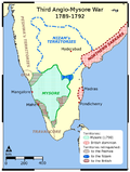 Dritter Mysore-Krieg
 Karte von 1793
 Karte von 1800
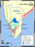 Vierter Mysore-Krieg
Literatur
- Martin Christof-Füchsle: "Quellen zu den Mysore-Kriegen (1766–1799) aus deutschen Archiven." in: MIDA Archival Reflexicon (2018), ISSN 2628-5029, 1–11.
Einzelnachweise
- ↑ Edward Thornton (Hrsg.): The History of the British Empire in India. Adamant Media Corporation, 2001, ISBN 0-543-80329-5 (EA London 1843)
- ↑ George Alfred Henty: The Tiger of Mysore. A Story of the War with Tippoo Saib. BiblioBazaar, 2007, ISBN 978-0-554-15191-5 (Roman, EA London 1896)
- ↑ Richard Holmes: Wellington. The Iron Duke. Taschenbuchausg. HarperCollins, London 2003, ISBN 0-00-713750-8.
Auf dieser Seite verwendete Medien

This map (noted as "Third Edition"), created immediately after the Fourth Anglo-Mysore War (1798–1799), is based on the 1793 Faden map (without any version note), created immediately after the Third Anglo-Mysore War (1789-92) and the subsequent division of and territorial loss by the Kingdom of Mysore through the 1792 Treaty of Seringapatam. The only difference from the older map is in political territory, showing vast expansion of the territory of the British East India Company (over that gained by the 1792 Treaty of Seringapatam), and the now much smaller Princely State of Mysore, after the Kingdom of Mysore having further lost territory to the East India Company's Madras Presidency, and one of the company's allies in the Anglo-Mysore Wars, the Princely state (from 1798) of Hyderabad state (contemporary sources refer to its hereditary ruler, the Nizam (of Hyderabad) in place of his territories).
The original 1773 map, with this map showing only territorial changes, was, according to the notes on the map, "compiled chiefly from papers communicated by the late Sir Archibald Campbell, the surveys of Col. Kelly, Capt. Pringle, Capt. Allan, etc." by Major James Rennell, and not based on his own surveys as Surveyor-General of the British East India Company, which were conducted in the Ganges basin.
Description from Geographicus: This is James Rennell's magnificent mapping of the Indian subcontinent, one of the largest and most impressive maps of India to appear in the 18th century. Highly desirable third edition. Presented in two panels, as issued. This chart depicts the subcontinent from Bombay ( Mumbai ) and Aurangabad, south including the northern half of Sri Lanka (Ceylon). Color coded according to political territory, noting British Possessions (red), the territory claimed by the independent holdout Rajah of Mysore (Purple), the Marhatta Countries (Green), the Nizam Dominions (Orange), the Carnatick (Yellow), and the Travancore (Blue). Includes the routes of various military marches and campaigns relating to the British conquest of India, including the 1784 March of British Prisoners from Condapoor to Madras, the march of the Marquis of Cornwallis, the march of General Medows, and the march of General Abercromby. Also shows the acquisitions of the British through the Partition Treaty of 1792. This map was engraved by R. Baker and printed in by William Faden, “Royal Geographer to the King and to the Prince of Wales”. The whole is masterfully presented in visually stunning almost three dimensional engraving and stunning period color. A must for any serious collection of South Asia maps. Compiled by James Rennell from papers communicated by the late Sir Archibald Campbell, the surveys of Col. Kelly, Capt. Pringle, Capt. Allan, etc.
Autor/Urheber: Die Autorenschaft wurde nicht in einer maschinell lesbaren Form angegeben. Es wird Miljoshi als Autor angenommen (basierend auf den Rechteinhaber-Angaben)., Lizenz: CC BY 2.5
Map illustration showing the territories involved in the Fourth Anglo-Mysore War between the Kingdom of Mysore of southern India and the British East India Company.
Map reference: University of Pennsylvania at [1] (URL accessed: 12-MAR-2006)![[1]](http://web.archive.org/web/20050403010455/www.history.upenn.edu/coursepages/hist086/material/schmidt33a.jpg)

Autor/Urheber: Die Autorenschaft wurde nicht in einer maschinell lesbaren Form angegeben. Es wird Miljoshi als Autor angenommen (basierend auf den Rechteinhaber-Angaben)., Lizenz: CC BY 2.5
Map illustration showing the territories involved in the Third Anglo-Mysore War between the Kingdom of Mysore of southern India and the British East India Company.
Map reference: University of Pennsylvania at [1] (URL accessed: 12-MAR-2006)![[1]](http://www.history.upenn.edu/coursepages/hist086/material/schmidt33a.jpg)

This map, created immediately after the Third Anglo-Mysore War (1789-92), shows the division of and territorial loss by the Kingdom of Mysore through the 1792 Treaty of Seringapatam.
A "third edition" was created in 1800 showing the territorial changes after the Fourth Anglo-Mysore War (1798–1799).
Description from Geographicus:
One of the largest and most impressive maps of India to appear in the 18th century. Depicts the subcontinent from Bombay ( Mumbai ) and Aurungabad, south including the northern half of Sri Lanka ( Ceylon ). Printed in 1793 in London by William Faden, “Royal Geographer to the King and to the Prince of Wales”. Includes the routes of various military marches and campaigns including the 1784 March of British Prisoners from Condapoor to Madras, the march of the Marquis of Cornwallis, the march of General Medows, and the march of General Abercromby. Also shows the acquisitions of the British through the Partition Treaty of 1792. The whole is masterfully presented in visually stunning almost three dimensional detail and stunning period color. A must for any serious collection of south Asia maps. Compiled chiefly from papers communicated by the late Sir Archd. Campbell, the surveys of Col. Kelly, Capt. Pringle, Capt. Allan, etc.
Autor/Urheber: Die Autorenschaft wurde nicht in einer maschinell lesbaren Form angegeben. Es wird Miljoshi als Autor angenommen (basierend auf den Rechteinhaber-Angaben)., Lizenz: CC BY 2.5
Map illustration showing the territories involved in the first and the Second Anglo-Mysore War between the Kingdom of Mysore of southern India and the British East India Company.
Map reference: University of Pennsylvania at [1] (URL accessed: 12-MAR-2006)"Haidar Ali, commander of the Marathas". French painting from 1762, published at the end of the Seven Years War. The Nawab of Mysore fought against the British for many years. In 1782 he received the help of the French squadron of Suffren, but he died before the end of the war