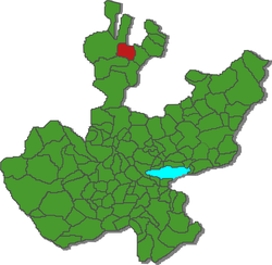
Municipio Villa Guerrero (Jalisco)
| Villa Guerrero | ||
|---|---|---|
 | ||
| Symbole | ||
| ||
| Basisdaten | ||
| Staat | Mexiko | |
| Bundesstaat | Jalisco | |
| Sitz | Villa Guerrero | |
| Fläche | 675 km² | |
| Einwohner | 5638 (2010) | |
| Dichte | 8,35 Einwohner pro km² | |
| Gründung | 1921 | |
| INEGI-Nr. | 14115 | |
| Politik | ||
| Presidente municipal | Rodolfo Rivas Valdés | |
| Villa Guerrero | ||
Koordinaten: 21° 59′ N, 103° 36′ W
Villa Guerrero ist ein Municipio im mexikanischen Bundesstaat Jalisco in der Región Norte. Das Municipio hatte beim Zensus 2010 5.638 Einwohner; die Fläche des Municipios beträgt 675 km².
Einziger Ort im Municipio mit zumindest 500 Einwohnern und Verwaltungssitz ist das gleichnamige Villa Guerrero (bis 1921 El Salitre genannt). Das Municipio umfasst insgesamt 61 Ortschaften.
Das Municipio Villa Guerrero grenzt an die Municipios Totatiche, Mezquitic, Chimaltitán und Bolaños sowie ans Municipio Monte Escobedo im Bundesstaat Zacatecas.
Das Gemeindegebiet liegt auf 900 m bis 2100 m Höhe. Mehr als zwei Drittel der Gemeindefläche sind bewaldet, 14 % sind Weideflächen, weitere 10 % werden landwirtschaftlich genutzt.
Weblinks
- jalisco.gob.mx: Villa Guerrero (spanisch)
- INEGI: Datos Geográficos: Municipio Villa Guerrero (spanisch; PDF)
- Enciclopedia de los Municipios y Delegaciones de México: Municipio Villa Guerrero (spanisch)
Auf dieser Seite verwendete Medien
Autor/Urheber: SEIJAL, Gobierno del Estado de Jalisco, Authorization available at [1], Lizenz: CC-BY-SA-3.0
Coat of Arms of Villa Guerrero, Jalisco
Autor/Urheber: Arturo Ramos, Lizenz: CC BY-SA 2.5
Panoramic view of the center of Villa Guerrero, Jalisco with municipal library in front and steeple of main catholic temple in background.
Vista panoramica del centro de Villa Guerrero, Jalisco con la bibliotecas municipal en frent y la torre del templo catolico principal por detras.Autor/Urheber: Humberto A.S.V. HASV Humberto, Mex, Lizenz: CC BY-SA 2.5
Ubicacion del municipio de Villa Guerrero en Jalisco.
Official coat of arms of the mexican state of Jalisco, in accordance to the Governement.


