Municipio Natívitas
| Natívitas | ||
|---|---|---|
 | ||
| Symbole | ||
| ||
| Basisdaten | ||
| Staat | Mexiko | |
| Bundesstaat | Tlaxcala | |
| Sitz | Natívitas | |
| Fläche | 52,7 km² | |
| Einwohner | 25.053 (2015) | |
| Dichte | 475,8 Einwohner pro km² | |
| Webauftritt | nativitas.gob.mx | |
| INEGI-Nr. | 29023 | |
| Politik | ||
| Presidente municipal | Cuauhtémoc Barranco Palacio | |
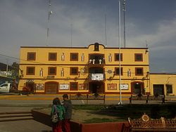
| Palacio municipal von Natívitas | ||
Koordinaten: 19° 14′ 0″ N, 98° 19′ 0″ W
Natívitas ist ein Municipio im mexikanischen Bundesstaat Tlaxcala. Das Gemeindegebiet erstreckt sich über eine Fläche von 52,7 km², beim Zensus 2010 wurden 23.621 Einwohner im Municipio gezählt. Verwaltungssitz ist das gleichnamige Natívitas, einwohnerreichster Ort ist hingegen Santiago Michac.
Geographie
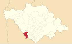
Das Municipio Natívitas liegt im Südwesten des Bundesstaates einer Höhe von 2200 m bis 2300 m. Es zählt zur Gänze zur physiographischen Provinz der Sierra Volcánica Transversal. Das Municipio entwässert zur Gänze über den Río Balsas in den Pazifik. Geologisch setzt sich das Gemeindegebiet aus 63 % Alluvialboden und 23 % Tuffstein zusammen. Bodentyp von 58 % des Municipios ist Phaeozem bei 19 % Cambisol. Etwa 88 % des Municipios werden landwirtschaftlich genutzt.
Das Municipio Natívitas grenzt an die Municipios Tepetitla de Lardizábal, Ixtacuixtla de Mariano Matamoros, Santa Ana Nopalucan, Tepeyanco, Santa Apolonia Teacalco, Tetlatlahuca, Santa Apolonia Teacalco und Zacatelco sowie im Süden und Westen an den mexikanischen Bundesstaat Puebla.
Bevölkerung
Beim Zensus 2010 wurden im Municipio 23.621 Menschen in 5.264 Wohneinheiten gezählt. Weniger als ein Prozent davon sind Sprecher einer indigenen Sprache, darunter 28 Sprecher des Nahuatl und 14 des Mazateco. Etwa 4,6 % der Bevölkerung waren Analphabeten. 8.681 Einwohner Natívitas’ wurden als Erwerbspersonen registriert, wovon etwa 72 % Männer bzw. 2,4 % arbeitslos waren. 13,2 % der Bevölkerung lebten in extremer Armut.
Orte
Das Municipio Natívitas umfasst 34 localidades, von denen neben dem Hauptort Santiago Michac, Santo Tomás la Concordia, San Rafael Tenanyecac und San Vicente Xiloxochitla vom INEGI als urban klassifiziert sind. Zehn Orte wiesen beim Zensus 2010 eine Einwohnerzahl von über 1000 auf:
| Ort | Einwohner |
| Santiago Michac | 3.533 |
| Santo Tomás la Concordia | 2.798 |
| San Rafael Tenanyecac | 2.699 |
| San Vicente Xiloxochitla | 2.418 |
| San Miguel Xochitecatitla | 2.124 |
| San José Atoyatenco | 1.672 |
| San Miguel Analco | 1.482 |
| Natívitas | 1.421 |
| San Miguel del Milagro | 1.117 |
| Jesús Tepactepec | 1.035 |
Weblinks
- Enciclopedia de los Municipios y Delegaciones de México: Municipio Natívitas (spanisch)
- INEGI: Datos Geográficos: Municipio Natívitas (spanisch; PDF)
Auf dieser Seite verwendete Medien
Autor/Urheber: Isaac Vásquez, Lizenz: CC BY-SA 3.0
Presidencia municipal de Natívitas Tlaxcala
Mapa de localización del municipio de Natívitas en Tlaxcala, México
The royal shield that Charles V & his mother, Queen Juana, granted to the city of Tlaxcala, is made on a red background of which stands out a golden castle with blue doors and windows of three towers, highlighting in the middle a pavilion with a rampant eagle that rules over a gold-colored field, & at the side ends a green palm tree protrudes; on the upper edge are the letters "I", & "K", & "F", & the first two correspond to the initials of the royal couple Isabella of Portugal & Charles V, while the third alludes to the Infante Philip, heir to the throne, & among the spaces of the initials are the two royal crowns that correspond to the aforementioned monarchs, & at the bottom edge you can see in the center 2 yellow bones crossed like blades, & at the ends 2 skulls, the green palm branches symbolize the glory & greatness of Spain & Tlaxcala.


