Municipio Los Cabos
| Los Cabos | ||
|---|---|---|
 | ||
| Symbole | ||
| ||
| Basisdaten | ||
| Staat | Mexiko | |
| Bundesstaat | Baja California Sur | |
| Sitz | San José del Cabo | |
| Fläche | 3760 km² | |
| Einwohner | 238.487 (2010) | |
| Dichte | 63,4 Einwohner pro km² | |
| Gründung | 1981 | |
| Webauftritt | www.loscabos.gob.mx | |
| INEGI-Nr. | 03008 | |
| Politik | ||
| Presidente municipal | Jesús Armida Castro Guzmán | |
(c) Stan Shebs, CC BY-SA 3.0 | ||
Koordinaten: 23° 12′ N, 109° 42′ W
| Los Cabos | ||||||||||||||||||||||||||||||||||||||||||||||||
|---|---|---|---|---|---|---|---|---|---|---|---|---|---|---|---|---|---|---|---|---|---|---|---|---|---|---|---|---|---|---|---|---|---|---|---|---|---|---|---|---|---|---|---|---|---|---|---|---|
| Klimadiagramm | ||||||||||||||||||||||||||||||||||||||||||||||||
| ||||||||||||||||||||||||||||||||||||||||||||||||
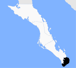
Los Cabos ist der südlichste Bezirk (municipio) des mexikanischen Bundesstaates Baja California Sur. Das Municipio hatte beim Zensus 2010 238.487 Einwohner, die Fläche beläuft sich auf 3760 km². Sitz der Bezirksverwaltung ist San José del Cabo; eine weitere bedeutende Stadt des Bezirks ist Cabo San Lucas.
Geographie

Das Municipio Los Cabos zählt zur Gänze zur physiographischen Provinz der Halbinsel Niederkalifornien, an deren Südspitze, im Süden des Bundesstaates Baja California Sur, es sich befindet. Es liegt auf bis zu 1800 m Höhe. Geologisch setzt sich das Municipio aus gut 50 % Intrusivgestein, etwa 33 % Sedimentgestein, 9 % Alluvionen und 2,5 % Extrusivgestein zusammen, vorherrschende Bodentypen sind der Regosol (51 %) und der Leptosol (36 %). Gut die Hälfte der Bezirksfläche ist bewaldet, gut 40 % sind von Gestrüpplandschaft bedeckt.
Das Municipio grenzt im Norden und Westen an das Municipio La Paz sowie im Süden und Osten an den Pazifik.
Bevölkerung
Das Municipio zählt laut Zensus 2010 238.487 Einwohner in etwa 65.000 Wohneinheiten. Davon wurden 4114 Personen als Sprecher einer indigenen Sprache registriert, darunter 1260 Sprecher des Nahuatl und 603 Sprecher des Popoloca. Etwa 2,9 % der Bevölkerung waren Analphabeten. 110.085 Einwohner wurden als Erwerbspersonen registriert, wovon ca. 66 % Männer bzw. 6,6 % arbeitslos waren. 5,6 % der Bevölkerung lebten in extremer Armut.
Der Bezirk hatte 2017 die weltweit höchste Mordrate pro Einwohner.[1]
Orte und Gliederung
Das Municipio Los Cabos umfasst 549 bewohnte localidades, von denen vom INEGI neben dem Hauptort auch Cabo San Lucas, Colonia del Sol, Las Palmas, Las Veredas und San José Viejo als urban klassifiziert sind. Sechs Orte wiesen beim Zensus 2010 eine Einwohnerzahl von über 5000 auf, weitere 13 Orte hatten zumindest 500 Einwohner, 507 Orte weniger als 100 Einwohner. Die größten Orte des Municipios sind:
| Ort | Bevölkerung |
|---|---|
| San José del Cabo | 69.788 |
| Cabo San Lucas | 68.463 |
| Colonia del Sol | 48.032 |
| Las Palmas | 11.562 |
| Las Veredas | 10.478 |
| San José Viejo | 7.222 |
| La Ribera | 2.050 |
| San Bernabé | 1.794 |
| La Playa | 1.417 |
| Miraflores | 1.384 |
Der Bezirk gliedert sich in vier delegaciones: Cabo San Lucas, La Ribera, Miraflores und Santiago.
Tourismus
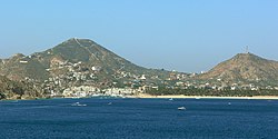
Wichtigster Wirtschaftsfaktor des Municipios ist der Tourismus. Das Ferienzentrum Los Cabos wird gebildet aus Cabo San Lucas und dem 32 km weiter östlich gelegenen Badeort San José del Cabo. Zwischen den beiden Orten befinden sich hauptsächlich elegante Hotelanlagen. In der Region von Los Cabos finden sich hohe Bergketten, karge Sandwüsten, Strände und tiefblauer Ozean. Los Cabos ist bekannt für seine Felsformationen El Arco an denen der Pazifik die warmen Gewässer des Golfs von Kalifornien trifft.
Literatur
- Paul Ganster, Antonina Ivanova, Oscar Arizpe C. (Hrsg.): Los Cabos: Prospective for a Natural and Tourism Paradise. San Diego State University Press and Institute for Regional Studies of the Californias, San Diego 2013, ISBN 978-1-938537-00-4.
Weblinks
- Enciclopedia de los Municipios y Delegaciones de México: Municipio Los Cabos (spanisch)
- INEGI: Datos Geográficos: Municipio Los Cabos (spanisch; PDF)
Einzelnachweise
- ↑ Höchste Mord-Rate weltweit Mexico News Daily, 8. März 2019
Auf dieser Seite verwendete Medien
Escudo del municipio fuentes: https://www.heraldry-wiki.com/heraldrywiki/wiki/Los_Cabos
The Copernicus Sentinel-2 mission takes us over Los Cabos – a municipality on the southern tip of Mexico's Baja California Peninsula.
Zoom in to see this image at its full 10 m resolution or click on the circles to learn more about the features in it.
Meaning ‘the capes’ in Spanish, Los Cabos is a region composed of mountains and coastal plains and is largely dry and rocky with over 320 days of sunshine each year. The area encompasses the two cities of Cabo San Lucas (visible in the bottom-left) and San José del Cabo (visible to the right).
The area along the coast between the two cities, often referred to as the Los Cabos Resort Corridor or simply the Corridor, stretches around 30 km along the highway and features a plethora of beaches dotted primarily with hotels, resorts and golf courses.
The peninsula ends with the Arch of Cabo San Lucas, known locally as ‘El Arco’ or ‘Land’s End.’ This distinctive land formation, carved by winds and waves, is where the Pacific Ocean meets the Gulf of California, also known as the Sea of Cortez.
The Arch of Cabo San Lucas is adjacent to Lovers Beach (Playa del Amor) on the Sea of Cortez side and Divorce Beach (Playa del Divorcio) on the rougher Pacific Ocean side. The arch is a popular gathering area for sea lions and is frequented by tourists.
A region of mountains dominate the landscape including the Sierra de la Laguna Mountain Range and the Sierra de San Lázaro, which are both formed of volcanic rock with peaks between 400 and 1000 m.
The main river in the area is the San José River, visible in the right of the image, and flows north to south primarily during the summer rainy season. The river creates an estuary at its southern end, which is one of the largest in Mexico and is home to both native and migratory birds.
This image, which is also featured on the Earth from Space video programme, has been processed in a way that included the Copernicus Sentinel-2’s near-infrared channel, which makes vegetation appear bright red. As the image was acquired on 20 June 2020, the region is particularly dry with little vegetation visible. A comparison showing the high-density of vegetation in the area during the rainy season is available here.
Mapa del municipio de Los Cabos en el estado de Baja California Sur en México
Coat of arms of Baja California Sur. Shades on the coat of arms are as follows:
- PANTONE 534 C
- PANTONE 485 C
- PANTONE YELLOW C
- PANTONE 429 C


