Mundua-Inseln
| Mundua-Inseln | ||
|---|---|---|
 | ||
| Gewässer | Bismarcksee | |
| Archipel | Vitu-Inseln (Bismarck-Archipel) | |
| Geographische Lage | 4° 38′ S, 149° 21′ O | |
| Anzahl der Inseln | 6 | |
| Hauptinsel | Mundua | |
| Gesamte Landfläche | 8 km² | |
| Einwohner | 1315 (2000) | |
Die Mundua-Inseln, auch Ningau-Inseln genannt, sind eine Inselgruppe aus sechs kleinen Inseln, gelegen 100 km nördlich von Neubritannien im Nordwesten der Vitu-Inseln (Bismarck-Archipel). Die Gruppe gehört zu Papua-Neuguinea, Provinz West New Britain.
Die Inselgruppe erstreckt sich über eine Länge von 10 Kilometer und hat eine Gesamtfläche von 8,0 km². Zur Volkszählung 2000 betrug die Bevölkerung 1315,[1] überwiegend auf der im Osten der Gruppe gelegenen Hauptinsel Mundua (Ningau).[2] Die übrigen Inseln sind wesentlich kleiner und überwiegend unbewohnt.
Liste der Inseln
| Inselname | Aliasname | Koordinaten | Fläche | Einwohner | Anmerkung |
|---|---|---|---|---|---|
| Mundua | Ningau | 04° 37′ S, 149° 21′ O | 5,75 | … | Hauptinsel |
| Wingoru | 04° 37′ S, 149° 19′ O | … | … | ||
| Chilling | 04° 38′ S, 149° 49′ O | … | … | ||
| Wambu | Vambu | 04° 38′ S, 149° 18′ O | … | – | |
| Lumboila | 04° 38′ S, 149° 17′ O | … | – | ||
| Undaka | 04° 37′ S, 149° 17′ O | … | – |
Weblinks
- Mundua. (Memento vom 24. November 2010 im Internet Archive) oceandots.com (englisch, mit SAT-Bild)
- Karte der Vitu-Inseln mit Details auch zu den Mundua-Inseln. nla.gov.au
Einzelnachweise
- ↑ Michael Bourke, Tracy Harwood: Food and Agriculture in Papua New Guinea. 2009, S. 49, books.google.de
- ↑ Sechs der acht auf der Karte verzeichneten Dörfer liegen auf der Hauptinsel, die übrigen auf Chilling und Wingoru.
Auf dieser Seite verwendete Medien
(c) OOjs UI Team and other contributors, MIT
An icon from the OOjs UI MediaWiki lib.
Transparent red circle
Autor/Urheber: Carport, Lizenz: CC BY-SA 3.0
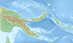
Physische Positionskarte von Papua-Neuguinea
A cluster of basaltic volcanoes forms the Mundua Islands, north of New Britain. The largest volcanic center is formed by the western tip of the 7-km-wide, Mundua Island and the arcuate Wingoru Island immediately to the west (left of the large cloud banks at the SW side of Mundua). The crater of this volcano is flooded by the sea through narrow channels on the northern and southern sides. Small cones can be seen on the eastern side of Mundua. The western tip of Garove Island is visible at the lower right in this NASA Landsat image.


