Mukim (Brunei)
Ein Mukim ist ein Unterdistrikt eines Daerah (Distrikt) in Brunei. Eine direkte Übersetzung ist Bezirk oder Verwaltungsbezirk. Die vier Distrikte Bruneis sind in 39 Mukims unterteilt.
| Nr. | Distrikt | Karte | Mukims | Anzahl |
|---|---|---|---|---|
| 1. |  Brunei-Muara |  (Karte vor der Aufteilung von Gadong in A und B) | Berakas A Berakas B Burong Pingai Ayer Gadong A Gadong B Kianggeh Kilanas Kota Batu Lumapas Mentiri Pengkalan Batu Peramu Saba Sengkurong Serasa Sungai Kebun Sungai Kedayan Tamoi | 18 |
| 2. |  Belait |  | Bukit Sawat Kuala Balai Kuala Belait Labi Labi Melilas Seria Sukang | 8 |
| 3. |  Tutong |  | Keriam Kiudang Lamunin Pekan Tutong Rambai Tanjong Maya Telisai Ukong | 8 |
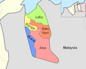
| 4. |  Temburong |  | Amo Bangar Batu Apoi Bokok Labu | 5 |
Auf dieser Seite verwendete Medien
Map of the mukims of Tutong district in Brunei.
Autor/Urheber: User:Golbez, Lizenz: CC BY-SA 3.0
Map of Brunei showing Belait district
Map of the mukims of Brunei and Muara district in Brunei. Created by Rarelibra 21:51, 11 September 2006 (UTC) for public domain use, using MapInfo Professional v8.5 and various mapping resources.
Map of the mukims (subdivisions) of the Temburong District of Brunei, in the northwest of the island of Borneo. Created by Rarelibra 21:37, 11 September 2006 (UTC) for public domain use, using MapInfo Professional v8.5 and various mapping resources.
Map of the mukims of the Belait district of Brunei. Created by Rarelibra 21:31, 11 September 2006 (UTC) for public domain use, using MapInfo Professional v8.5 and various mapping resources.
Autor/Urheber: User:Golbez, Lizenz: CC BY-SA 3.0
Map of Brunei showing Tutong district
Autor/Urheber: User:Golbez, Lizenz: CC BY-SA 3.0
Map of Brunei showing Brunei and Muara district.
Autor/Urheber: User:Golbez, Lizenz: CC BY-SA 3.0
Karte Bruneis mit den Temburong-Distrikt (koloriert)


