Mount Pisgah (Südliche Shetlandinseln)
| Mount Pisgah | ||
|---|---|---|
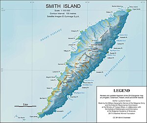
 Karte von Smith Island mit dem Mount Pisgah (Mitte rechts) | ||
| Höhe | 1860 m | |
| Lage | Smith Island, Südliche Shetlandinseln | |
| Gebirge | Imeon Range | |
| Koordinaten | 62° 56′ 53″ S, 62° 29′ 1″ W | |
| Normalweg | Hochtour (vergletschert) | |
Mount Pisgah (in Argentinien Monte Pisco, in Chile Monte Pisgah) ist ein 1860 m hoher Berg auf im Archipel der Südlichen Shetlandinseln. In der Imeon Range ragt er 5 km südwestlich des Mount Christi und 6 km nordöstlich des Mount Foster im nordzentralen Teil der Insel auf.
US-amerikanische Robbenjäger benannten ihn in den 1820er Jahren nach einem gleichnamigen Berg in Durham, Connecticut.
Weblinks
- Mount Pisgah. In: Geographic Names Information System. United States Geological Survey, United States Department of the Interior, archiviert vom (englisch).
- Mount Pisgah auf geographic.org (englisch)
Auf dieser Seite verwendete Medien
Autor/Urheber: Apcbg, Lizenz: CC BY-SA 4.0
L.L. Ivanov. Antarctica: Smith Island. Scale 1:100000 topographic map. Manfred Wörner Foundation, 2017. Revised and updated version of the first topographic map of Smith Island, fragment of the author’s 2010 map of Livingston Island and Greenwich, Robert, Snow and Smith Islands.
Autor/Urheber: NordNordWest, Lizenz: CC BY-SA 3.0
Positionskarte der Südlichen Shetlandinseln


